Deelgebieden van Sao Tomé en Principe
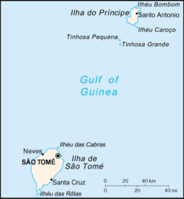

De Afrikaanse eilandstaat Sao Tomé en Principe bestaat uit twee informele provincies en zeven districten. De zeven districten zijn weer verder opgedeeld in achttien subdistricten.[1] In dit artikel worden de gebruikte cijfers overgenomen van het Santomees nationaal statistisch instituut[2] en van de volkstelling uit 2012.[1] Voor 2019 is een schatting gebruikt.
Provincies
| Provincie | Hoofdstad | Opp. (km²)[2] | Inw. (2012)[1] | Inw. (2019)[3] | Bev. dichtheid (/km²) |
|---|---|---|---|---|---|
| Sao Tomé | Sao Tomé | 859,0 | 179.814 | 197.390 | 209 |
| Principe | Santo António | 142,0 | 7.542 | 8.610 | 53 |
Districten
| # | District | Hoofdstad | Opp. (km²)[2] | Inw. (2012)[1] | Inw. (2019)[3] | Bev. dichtheid (/km²) | Kamerzetels |
|---|---|---|---|---|---|---|---|
| Provincie Sao Tomé | |||||||
| 1 | Água Grande | Sao Tomé | 16,5 | 73.091 | 79.200 | 4.430 | 13 |
| 2 | Cantagalo | Santana | 119,0 | 18.194 | 19.800 | 153 | 7 |
| 3 | Caué | São João dos Angolares | 267,0 | 6.887 | 7.390 | 26 | 5 |
| 4 | Lembá | Neves | 229,5 | 15.370 | 16.600 | 67 | 6 |
| 5 | Lobata | Guadalupe | 105,0 | 20.007 | 22.500 | 191 | 6 |
| 6 | Mé-Zóchi | Trindade | 122,0 | 46.265 | 51.900 | 379 | 13 |
| Provincie Príncipe | |||||||
| 7 | Pagué | Santo António | 142,0 | 7.542 | 8.610 | 53 | 5 |
Bevolkingsontwikkeling
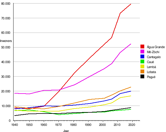 |
 |
Zie ook
- ISO 3166-2:ST
Bronnen, noten en/of referenties
|

Deelgebieden (hoofdsteden) van Sao Tomé en Principe
Provincies: Sao Tomé (Sao Tomé) · Principe (Santo António)
Districten: Água Grande (Sao Tomé) · Cantagalo (Santana) · Caué (São João dos Angolares) · Lembá (Neves) · Lobata (Guadalupe) · Mé-Zóchi (Trindade) · Pagué (Santo António)
Eilanden: Ilhéu Bom Bom · Ilhéu das Cabras · Ilhéu Caroço · Principe · Ilhéu das Rolas · Ilhéu de Santana · Sao Tomé · Tinhosa Grande · Tinhosa Pequena
Primaire deelgebieden van Afrikaanse landen
| Staten: | Nigeria · Soedan · Zuid-Soedan |
| Regio's: | Djibouti · Eritrea · Ethiopië · Ghana · Guinee · Guinee-Bissau · Kameroen · Madagaskar · Mali · Mauritanië · Marokko · Namibië · Niger · Senegal · Somalië · Tanzania · Togo |
| Provincies: | Algerije · Angola · Burkina Faso · Burundi · Congo-Kinshasa · Equatoriaal-Guinea · Gabon · Mozambique · Rwanda · Sao Tomé en Principe · Sierra Leone · Tsjaad · Zambia · Zimbabwe · Zuid-Afrika |
| Districten: | Botswana · Ivoorkust · Kaapverdië · Lesotho · Malawi · Mauritius · Oeganda · Seychellen · Swaziland |
| Diversen: | Autonome eilanden van de Comoren · County's van Kenia, Liberia · Departementen van Benin, Congo-Brazzaville · Divisies van Gambia · Gemeenten van Libië · Gouvernementen van Egypte, Tunesië · Prefecturen van de Centraal-Afrikaanse Republiek |


