Breckland
 Voor het automerk, zie Breckland Technology
 Niet-metropolitaans district in Engeland  | |||
|---|---|---|---|
  | |||
| Situering | |||
| Land | Engeland | ||
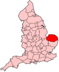
| County | Norfolk | ||
| Regio | East of England | ||
| Coördinaten | 52°38'NB, 0°59'OL | ||
| Algemeen | |||
| Oppervlakte | 1305,1168[1] km² | ||
| Inwoners (2018[2]) | 139.329 (107 inw./km²) | ||
| Hoofdplaats ONS-code | East Dereham E07000143 | ||
| Detailkaart | |||
 | |||
| |||

Breckland is een Engels district in het shire-graafschap (non-metropolitan county OF county) Norfolk en telt 139.000 inwoners. De oppervlakte bedraagt 1305 km². Hoofdplaats is Dereham.
Van de bevolking is 19,2% ouder dan 65 jaar. De werkloosheid bedraagt 2,6% van de beroepsbevolking (cijfers volkstelling 2001).
Plaatsen in district Breckland
- Great Hockham
- Rockland St Peter
- Wilby
Civil parishes in district Breckland
Ashill, Attleborough, Banham, Bawdeswell, Beachamwell, Beeston with Bittering, Beetley, Besthorpe, Billingford, Bintree, Blo' Norton, Bradenham, Brettenham, Bridgham, Brisley, Bylaugh, Carbrooke, Caston, Cockley Cley, Colkirk, Cranwich, Cranworth, Croxton, Dereham, Didlington, East Tuddenham, Elsing, Foulden, Foxley, Fransham, Garboldisham, Garvestone, Gateley, Gooderstone, Great Cressingham, Great Dunham, Great Ellingham, Gressenhall, Griston, Guist, Hardingham, Harling, Hilborough, Hockering, Hockham, Hoe, Holme Hale, Horningtoft, Ickburgh, Kempstone, Kenninghall, Kilverstone, Lexham, Litcham, Little Cressingham, Little Dunham, Little Ellingham, Longham, Lynford, Lyng, Mattishall, Merton, Mileham, Mundford, Narborough, Narford, Necton, New Buckenham, Newton by Castle Acre, North Elmham, North Lopham, North Pickenham, North Tuddenham, Old Buckenham, Ovington, Oxborough, Quidenham, Riddlesworth, Rocklands, Roudham and Larling, Rougham, Saham Toney, Scarning, Scoulton, Shipdham, Shropham, Snetterton, South Acre, South Lopham, South Pickenham, Sparham, Sporle with Palgrave, Stanfield, Stanford, Stow Bedon, Sturston, Swaffham, Swanton Morley, Thetford, Thompson, Tittleshall, Tottington, Twyford, Watton, Weasenham All Saints, Weasenham St. Peter, Weeting-with-Broomhill, Wellingham, Wendling, Whinburgh and Westfield, Whissonsett, Wretham, Yaxham.
Bronnen, noten en/of referenties
|


