Watsonville

Watsonville
Plaats in de Verenigde Staten Vlag van Verenigde Staten
Watsonville (Californië)
Watsonville
Locatie van Watsonville in Californië
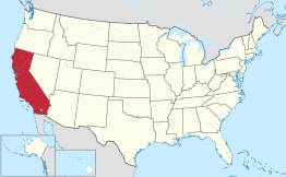
Locatie van Californië in de VS
Situering
County Santa Cruz County
Type plaats City
Staat Californië
Coördinaten 36° 55′ NB, 121° 46′ WL
Algemeen
Oppervlakte 16,4 km²
- land 16,2 km²
- water 0,2 km²
Inwoners
(2006)
48.709
Hoogte 9 m
Overig
ZIP-code(s) 95076, 95077
FIPS-code 83668
Foto's
downtown
downtown
Portaal  Portaalicoon   Verenigde Staten

Watsonville is een plaats (city) in de Amerikaanse staat Californië, en valt bestuurlijk gezien onder Santa Cruz County.

Demografie

Bij de volkstelling in 2000 werd het aantal inwoners vastgesteld op 44.265.[1] In 2006 is het aantal inwoners door het United States Census Bureau geschat op 48.709,[2] een stijging van 4444 (10.0%).

Geografie

Volgens het United States Census Bureau beslaat de plaats een oppervlakte van 16,6 km², waarvan 16,4 km² land en 0,2 km² water.

Plaatsen in de nabije omgeving

De onderstaande figuur toont nabijgelegen plaatsen in een straal van 8 km rond Watsonville.

WatsonvilleWatsonville
Plaats met 2436 inwoners (2000). Amesti (5 km)
Plaats met 2361 inwoners (2000). Aptos Hills-Larkin Valley (8 km)
Plaats met 6000 inwoners (2000). Freedom (3 km)
Plaats met 7328 inwoners (2000). Interlaken (4 km)
Plaats met 3078 inwoners (2000). Las Lomas (7 km)
Plaats met 3384 inwoners (2000). Pajaro (3 km)

Geboren

  • Bob Scott (1928–1954), autocoureur
  • Joel Fabiani (28 september 1936), acteur

Externe link

  • (en) Statistieken, kaarten en andere informatie over Watsonville op city-data.com
Bronnen, noten en/of referenties
  1. (en) U.S. Census Bureau. Census 2000 Summary File 1
  2. (en) U.S. Census Bureau. Population estimates (July 2006)
· · Sjabloon bewerken
Californië

Hoofdstad: Sacramento

Regio's: Antelope Valley · Big Sur · Cascade Range · Central Coast · Central Valley · Channel Islands · Coachella Valley · Conejo Valley · Cucamonga Valley · Death Valley · East Bay · East County · Emerald Triangle · Gold Country · Greater Los Angeles · Grote Bekken · Imperial Valley · Inland Empire · Klamath Basin · Lake Tahoe · Los Angeles Basin · Lost Coast · Mojave · Mountain Empire · Noord-Californië · North Bay · North Coast · North County · Oost-Californië · Owens Valley · Oxnard Plain · San Francisco Peninsula · Pomona Valley · Sacramento Valley · San Bernardino Valley · San Diego–Tijuana · San Fernando Valley · San Francisco Bay Area · San Gabriel Valley · San Joaquin Valley · Santa Clara Valley · Santa Clarita Valley · Shasta Cascade · Sierra Nevada · Silicon Valley · South Bay (LA) · South Bay (SD) · South Bay (SF) · South Coast · Southern Border Region · Upstate California · Wine Country · Yosemite · Zuid-Californië

Metropolitane gebieden: Bakersfield · Chico · Fresno · Los Angeles-Long Beach-Glendale · Modesto · Napa · Oakland-Fremont-Hayward · Oxnard-Thousand Oaks-Ventura · Riverside-San Bernardino-Ontario · Sacramento-Roseville · Salinas · San Diego-Carlsbad-San Marcos · San Francisco-San Mateo-Redwood City · San Jose-Sunnyvale-Santa Clara · San Luis Obispo-Paso Robles · Santa Ana-Anaheim-Irvine · Santa Barbara-Santa Maria · Santa Cruz-Watsonville · Santa Rosa-Petaluma · Stockton · Vallejo-Fairfield · Visalia-Porterville · Yuba City

County's: Alameda · Alpine · Amador · Butte · Calaveras · Colusa · Contra Costa · Del Norte · El Dorado · Fresno · Glenn · Humboldt · Imperial · Inyo · Kern · Kings · Lake · Lassen · Los Angeles · Madera · Marin · Mariposa · Mendocino · Merced · Modoc · Mono · Monterey · Napa · Nevada · Orange · Placer · Plumas · Riverside · Sacramento · San Benito · San Bernardino · San Diego · San Francisco · San Joaquin · San Luis Obispo · San Mateo · Santa Barbara · Santa Clara · Santa Cruz · Shasta · Sierra · Siskiyou · Solano · Sonoma · Stanislaus · Sutter · Tehama · Trinity · Tulare · Tuolumne · Ventura · Yolo · Yuba

Portaal Californië