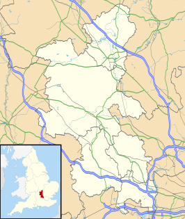
Stantonbury

Stantonbury
Civil parish in Engeland Vlag van Engeland
Stantonbury (Buckinghamshire)
Stantonbury
Situering
Nederzettingen Bancroft, Blue Bridge, Bradville, Linford Wood
Graafschap Buckinghamshire
Regio South East England
District Milton Keynes
Coördinaten 52° 4' NB, 0° 46' WL
Algemeen
Oppervlakte 6,1326 km²
Inwoners
(2011)
10084
(1644 inw./km²)
Grid code SP8453341685
Portaal  Portaalicoon   Verenigd Koninkrijk

Stantonbury (ONS-code E04012191) is een civil parish in het bestuurlijke gebied Milton Keynes, in het Engelse graafschap Buckinghamshire met 10.084 inwoners.

· · Sjabloon bewerken

Addington · Adstock · Akeley · Amersham · Ashendon · Ashley Green · Aston Abbotts · Aston Clinton · Aston Sandford · Astwood · Aylesbury · Barton Hartshorn · Beachampton · Beaconsfield · Biddlesden · Bierton with Broughton · Bledlow-cum-Saunderton · Bletchley and Fenny Stratford · Boarstall · Bow Brickhill · Bradenham · Bradwell · Bradwell Abbey · Brill · Broughton · Buckingham · Buckland · Burnham · Calvert Green · Calverton · Campbell Park · Castlethorpe · Central Milton Keynes · Chalfont St. Giles · Chalfont St. Peter · Charndon · Chartridge · Chearsley · Cheddington · Chenies · Chepping Wycombe · Chesham · Chesham Bois · Chetwode · Chicheley · Chilton · Cholesbury-cum-St. Leonards · Clifton Reynes · Cold Brayfield · Coldharbour · Coleshill · Creslow · Cublington · Cuddington · Denham · Dinton-with-Ford-and-Upton · Dorney · Dorton · Downley · Drayton Beauchamp · Drayton Parslow · Dunton · East Claydon · Edgcott · Edlesborough · Ellesborough · Emberton · Farnham Royal · Fawley · Fleet Marston · Foscott · Fulmer · Gawcott with Lenborough · Gayhurst · Gerrards Cross · Granborough · Great and Little Hampden · Great and Little Kimble · Great Brickhill · Great Horwood · Great Linford · Great Marlow · Great Missenden · Grendon Underwood · Haddenham · Halton · Hambleden · Hanslope · Hardmead · Hardwick · Haversham-cum-Little Linford · Hazlemere · Hedgerley · Hedsor · Hillesden · Hoggston · Hogshaw · Hughenden Valley · Hulcott · Ibstone · Ickford · Iver · Ivinghoe · Kents Hill, Monkston and Brinklow · Kingsey · Kingswood · Lacey Green · Lane End · Lathbury · Latimer · Lavendon · Leckhampstead · Lillingstone Dayrell · Lillingstone Lovell · Little Brickhill · Little Chalfont · Little Horwood · Little Marlow · Little Missenden · Long Crendon · Longwick-cum-Ilmer · Loughton · Ludgershall · Maids Moreton · Marlow · Marlow Bottom · Marsh Gibbon · Marsworth · Medmenham · Mentmore · Middle Claydon · Milton Keynes · Moulsoe · Mursley · Nash · Nether Winchendon · New Bradwell · Newport Pagnell · Newton Blossomville · Newton Longville · North Crawley · North Marston · Oakley · Olney · Oving · Padbury · Penn · Piddington and Wheeler End · Pitchcott · Pitstone · Poundon · Preston Bissett · Princes Risborough · Quainton · Quarrendon · Radclive-cum-Chackmore · Radnage · Ravenstone · Seer Green · Shabbington · Shalstone · Shenley Brook End · Shenley Church End · Sherington · Simpson · Slapton · Soulbury · Stantonbury · Steeple Claydon · Stewkley · Stoke Goldington · Stoke Hammond · Stoke Mandeville · Stoke Poges · Stokenchurch · Stone with Bishopstone and Hartwell · Stony Stratford · Stowe · Swanbourne · Taplow · The Lee · Thornborough · Thornton · Tingewick · Turville · Turweston · Twyford · Tyringham and Filgrave · Upper Winchendon · Waddesdon · Walton · Warrington · Water Stratford · Watermead · Wavendon · Weedon · Wendover · West Bletchley · West Wycombe · Westbury · Westcott · Weston Turville · Weston Underwood · Wexham · Whaddon · Whitchurch · Wing · Wingrave and Rowsham · Winslow · Woburn Sands · Wolverton and Greenleys · Wooburn and Bourne End · Woodham · Worminghall · Wotton Underwood · Woughton

Geplaatst op:
30-8-2010
Dit artikel is een beginnetje over landen & volken. U wordt uitgenodigd om op bewerken te klikken om uw kennis aan dit artikel toe te voegen. Beginnetje