Mole Valley
Niet-metropolitaans district in Engeland  | |||
|---|---|---|---|
 | |||
| Situering | |||
| Land | Engeland | ||
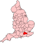
| County | Surrey | ||
| Regio | South East England | ||
| Coördinaten | 51°18'58"NB, 0°29'37"WL | ||
| Algemeen | |||
| Oppervlakte | 258,3211[1] km² | ||
| Inwoners (2018[2]) | 87253 (338 inw./km²) | ||
| ONS-code | E07000210 | ||
| Detailkaart | |||
[[Bestand: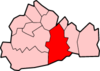 |266px|class=notpageimage|alt=Kaart van Mole Valley]] |266px|class=notpageimage|alt=Kaart van Mole Valley]] | |||
| |||

Mole Valley is een Engels district in het shire-graafschap (non-metropolitan county OF county) Surrey en telt 87.000 inwoners. De oppervlakte bedraagt 258 km².
Van de bevolking is 19,0% ouder dan 65 jaar. De werkloosheid bedraagt 1,6% van de beroepsbevolking (cijfers volkstelling 2001).
Steden
- Dorking
- Leatherhead
Plaatsen in district Mole Valley
- Abinger Common
- Abinger Hammer
- Ashtead
- Beare Green
- Coldharbour
- Fetcham
- Forest Green
- Great Bookham
- Holmbury St Mary
- Little Bookham
- Westcott
- Westhumble
Civil parishes in district Mole Valley
Abinger, Betchworth, Brockham, Buckland, Capel, Charlwood, Headley, Holmwood, Leigh, Mickleham, Newdigate, Ockley, Wotton.
Bronnen, noten en/of referenties
|


