La Tour-d'Aigues
Gemeente in Frankrijk  | |||
|---|---|---|---|
 | |||
  | |||
| Situering | |||
| Regio | Provence-Alpes-Côte d'Azur | ||
| Departement | Vaucluse (84) | ||
| Arrondissement | Apt | ||
| Kanton | Pertuis | ||
| Coördinaten | 43° 44′ NB, 5° 33′ OL | ||
| Algemeen | |||
| Oppervlakte | 41,3 km² | ||
| Inwoners (1 januari 2021) | 4.346[1] (105 inw./km²) | ||
| Hoogte | 220 - 510 m | ||
| Overig | |||
| Postcode | 84240 | ||
| INSEE-code | 84133 | ||
| Foto's | |||
 | |||
| |||

La Tour-d'Aigues is een gemeente in het Franse departement Vaucluse (regio Provence-Alpes-Côte d'Azur) en telt 3860 inwoners (1999). De plaats maakt deel uit van het arrondissement Apt.
Geografie
De oppervlakte van La Tour-d'Aigues bedraagt 41,1 km², de bevolkingsdichtheid is 93,9 inwoners per km².
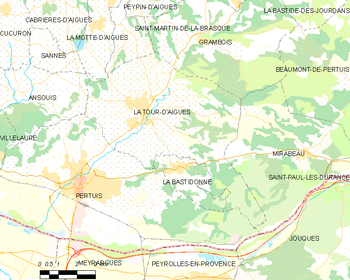
De onderstaande kaart toont de ligging van La Tour-d'Aigues met de belangrijkste infrastructuur en aangrenzende gemeenten.
 |
Demografie
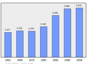
Onderstaande figuur toont het verloop van het inwonertal (bron: INSEE-tellingen).
Externe links
- Informatie over La Tour-d'Aigues
- (fr) Statistische informatie op de website van INSEE
Mediabestanden
Zie de categorie La Tour-d'Aigues van Wikimedia Commons voor mediabestanden over dit onderwerp.
- ↑ Populations légales 2021.


