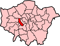
Hammersmith and Fulham
Borough van Londen  | |||
|---|---|---|---|
 | |||
 | |||
| Situering | |||
| Land | Engeland | ||
| County | Inner London | ||
| Regio | London | ||
| Coördinaten | 51°29'33"NB, 0°14'5"WL | ||
| Algemeen | |||
| Oppervlakte | 16,3976[1] km² | ||
| Inwoners (2018[2]) | 185426 (11308 inw./km²) | ||
| ONS-code | E09000013 | ||
| |||

Hammersmith and Fulham (London Borough of Hammersmith and Fulham) is een Engels district of borough in de regio Groot-Londen, gelegen in het centrale deel van de metropool. De borough telt 182.998 inwoners. De oppervlakte bedraagt 16 km².
Van de bevolking is 10,5% ouder dan 65 jaar. De werkloosheid bedraagt 5,0% van de beroepsbevolking (cijfers volkstelling 2001).
Wijken in Hammersmith and Fulham
- Fulham
- Hammersmith
- Sands End
- Shepherd's Bush
- White City
Partnersteden
 Anderlecht
 Boulogne-Billancourt
 Neukölln


Zie ook
- Hammersmith Bridge
Bronnen, noten en/of referenties
|


