Warmenhuizen
Village in North Holland, Netherlands
52°43′21″N 4°44′23″E / 52.72250°N 4.73972°E / 52.72250; 4.73972 (2021)[1]
1749[1]
Warmenhuizen (West Frisian: Wermehúze) is a town in the Dutch province of North Holland. It is a part of the municipality of Schagen, and lies about 8 km northwest of Heerhugowaard. An agricultural community. The area surrounding the town produces mainly dairy products, cabbage/potatoes, and hot house flowers. Mainly a Roman Catholic community featuring two churches, an old Protestant one, fallen into disuse, built in 16th century and a more modern Roman Catholic church constructed in the early 20th century.
Warmenhuizen was a separate municipality until 1990, when it was merged with Harenkarspel.[3] Harenkarspel merged with Schagen in 2013.
Notable people born in Warmenhuizen
- Antje Paarlberg (1808-1885)
- Joop Klant (1915-1994)
- Jos Pronk (1983)
- Steven Rooks, cyclist
Gallery
-
 Windmill Grebmolen
 -
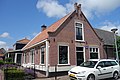 House in Warmenhuizen
 -
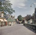 Street view
 -
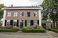 House in Warmenhuizen


References
- ^ a b c "Kerncijfers wijken en buurten 2021". Central Bureau of Statistics. Retrieved 1 May 2022.
three entries
- ^ "Postcodetool for 1749AA". Actueel Hoogtebestand Nederland (in Dutch). Het Waterschapshuis. Retrieved 1 May 2022.
- ^ Ad van der Meer and Onno Boonstra, Repertorium van Nederlandse gemeenten, KNAW, 2011.
- v
- t
- e
Populated places in the municipality of Schagen
- Burgerbrug
- Callantsoog
- Dirkshorn
- Eenigenburg
- Groenveld
- Groote Keeten [nl]
- Krabbendam
- Oudesluis
- Petten
- Schagerbrug
- Sint Maarten
- Sint Maartensbrug
- Sint Maartensvlotbrug
- Stroet
- Tuitjenhorn
- Valkkoog
- Waarland
- Warmenhuizen
- 't Zand
 | This North Holland location article is a stub. You can help Wikipedia by expanding it. |
- v
- t
- e


