Valkkoog
Village in North Holland, Netherlands
52°47′N 4°46′E / 52.783°N 4.767°E / 52.783; 4.767 (2021)[1]
1744[1]
Valkkoog (West Frisian: Falkekoeghe) is a village in the Dutch province of North Holland. It is a part of the municipality of Schagen, and lies about 12 km north of Heerhugowaard.
The village was first mentioned in 1318 as Valkencoech, and means "(settlement on) land near water of the Valke (person)".[3] Valkkoog was constructed on four terps (artificial hills) which date from around 1170. The monks of Egmond Abbey have later built a dike around the village. The church dates from the early 16th century, and is nowadays used for cultural activities. The church was rebuilt in 1839, and the tower was replaced in 1865. During World War II, more than 40 bunkers were built near the village by the Germans of which six still remain.[4]
Gallery
-
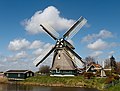 Windmill De Groenvelder
 -
 View on Valkkoog


References
- ^ a b c "Kerncijfers wijken en buurten 2021". Central Bureau of Statistics. Retrieved 1 May 2022.
- ^ "Postcodetool for 1744EG". Actueel Hoogtebestand Nederland (in Dutch). Het Waterschapshuis. Retrieved 1 May 2022.
- ^ "Valkkoog - (geografische naam)". Etymologiebank (in Dutch). Retrieved 1 May 2022.
- ^ "Valkkoog". Plaatsengids (in Dutch). Retrieved 1 May 2022.
Wikimedia Commons has media related to Valkkoog.
| Authority control databases: Geographic |
|
|---|
 | This North Holland location article is a stub. You can help Wikipedia by expanding it. |
- v
- t
- e


