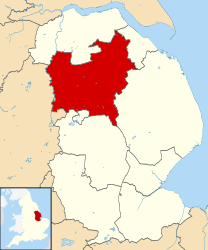
West Lindsey

Questa voce o sezione sull'argomento autorità unitarie dell'Inghilterra non cita le fonti necessarie o quelle presenti sono insufficienti.
| Distretto di West Lindsey Distretto | |
|---|---|
| West Lindsey District | |
| Localizzazione | |
| Stato |  Regno Unito Regno Unito Inghilterra Inghilterra |
| Regione | Midlands Orientali |
| Contea |  Lincolnshire Lincolnshire |
| Amministrazione | |
| Capoluogo | Gainsborough |
| Esecutivo | Liberal Democratico |
| Territorio | |
| Coordinate del capoluogo | 53°24′N 0°46′W53°24′N, 0°46′W (Distretto di West Lindsey) |
| Superficie | 1 155,71 km² |
| Abitanti | 89 400 (2011) |
| Densità | 77,36 ab./km² |
| Altre informazioni | |
| Fuso orario | UTC+0 |
| Codice ONS | 32UH |
| Rappresentanza parlamentare | Collegio di Gainsborough |
| Cartografia | |
  Gainsborough | |
 | |
| Sito istituzionale | |
| Modifica dati su Wikidata · Manuale | |
West Lindsey è un distretto del Lincolnshire, Inghilterra, Regno Unito, con sede a Gainsborough.
Il distretto fu creato con il Local Government Act 1972, il 1º aprile 1974 da parte della precedente contea di Lindsey, dalla fusione dei distretti urbani di Gainsborough e Market Rasen con il distretto rurale di Caistor, il distretto rurale di Gainsborough e il distretto rurale di Welton.
Parrocchie civili
- Aisthorpe
- Apley
- Bardney
- Barlings
- Bigby
- Bishop Norton
- Blyborough
- Blyton
- Brampton
- Brattleby
- Broadholme
- Brocklesby
- Brookenby
- Broxholme
- Bullington
- Burton
- Buslingthorpe
- Cabourne
- Caenby
- Caistor
- Cammeringham
- Cherry Willingham
- Claxby
- Corringham
- Dunholme
- East Ferry
- East Stockwith
- Faldingworth
- Fenton (West Lindsey)
- Fillingham
- Fiskerton
- Friesthorpe
- Fulnetby
- Gainsborough
- Gate Burton
- Glentham
- Glentworth
- Goltho
- Grange de Lings
- Grasby
- Grayingham
- Great Limber
- Greetwell
- Hackthorn & Cold Hanworth
- Hardwick
- Harpswell
- Heapham
- Hemswell
- Hemswell Cliff
- Holton cum Beckering
- Holton le Moor
- Ingham
- Keelby
- Kettlethorpe
- Kexby
- Kirmond le Mire
- Knaith
- Laughton
- Lea
- Legsby
- Linwood
- Lissington
- Market Rasen
- Marton
- Middle Rasen
- Morton
- Nettleham
- Nettleton
- Newball
- Newton on Trent
- Normanby by Spital
- Normanby le Wold
- North Carlton
- North Kelsey
- North Willingham
- Northorpe
- Osgodby
- Owersby
- Owmby
- Pilham
- Rand
- Reepham
- Riby
- Riseholme
- Rothwell
- Saxby
- Saxilby with Ingleby
- Scampton
- Scothern
- Scotter
- Scotton
- Searby cum Owmby
- Sixhills
- Snarford
- Snelland
- Snitterby
- Somerby
- South Carlton
- South Kelsey
- Spridlington
- Springthorpe
- Stainfield
- Stainton by Langworth
- Stainton le Vale
- Stow
- Sturton by Stow
- Sudbrooke
- Swallow
- Swinhope
- Tealby
- Thonock
- Thoresway
- Thorganby
- Thorpe in the Fallows
- Toft Newton
- Torksey
- Upton
- Waddingham
- Walesby
- Walkerith
- Welton
- West Firsby
- West Rasen
- Wickenby
- Wildsworth
- Willingham
- Willoughton
Altri progetti
Altri progetti
- Wikimedia Commons
 Wikimedia Commons contiene immagini o altri file su West Lindsey
Collegamenti esterni
- Sito ufficiale, su west-lindsey.gov.uk.

- (EN) West Lindsey, su Enciclopedia Britannica, Encyclopædia Britannica, Inc.

V · D · M | ||
|---|---|---|
| Autorità unitarie | North East Lincolnshire · North Lincolnshire |  |
| Distretti o Borough | Boston · East Lindsey · Lincoln · North Kesteven · South Holland · South Kesteven · West Lindsey | |
| Città e paesi | Alford · Barton-upon-Humber · Boston · Bourne · Brigg · Broughton · Burgh le Marsh · Caistor · Cleethorpes · Crowland · Crowle · The Deepings · Epworth · Gainsborough · Grantham · Grimsby · Holbeach · Horncastle · Immingham · Kirton-in-Lindsey · Lincoln · Long Sutton · Louth · Mablethorpe · Market Deeping · North Hykeham · Scunthorpe · Skegness · Sleaford · Spalding · Spilsby · Stamford · Wainfleet All Saints · Wragby | |
| Parrocchie civili del Lincolnshire | ||
 Portale Regno Unito: accedi alle voci di Wikipedia che parlano del Regno Unito


