Yquebeuf
You can help expand this article with text translated from the corresponding article in French. (May 2020) Click [show] for important translation instructions.
- Machine translation, like DeepL or Google Translate, is a useful starting point for translations, but translators must revise errors as necessary and confirm that the translation is accurate, rather than simply copy-pasting machine-translated text into the English Wikipedia.
- Do not translate text that appears unreliable or low-quality. If possible, verify the text with references provided in the foreign-language article.
- You must provide copyright attribution in the edit summary accompanying your translation by providing an interlanguage link to the source of your translation. A model attribution edit summary is
Content in this edit is translated from the existing French Wikipedia article at [[:fr:Yquebeuf]]; see its history for attribution. - You may also add the template
{{Translated|fr|Yquebeuf}}to the talk page. - For more guidance, see Wikipedia:Translation.
Commune in Normandy, France

Coat of arms
Location of Yquebeuf

(2020–2026) Georges Molmy[1]
1
(2021)[2]
76756 /76690
(avg. 160 m or 520 ft)
Yquebeuf (French pronunciation: [ikbœf]) is a commune in the Seine-Maritime department in the Normandy region in northern France.
Geography
A small farming village situated in the Pays de Bray, some 15 miles (24 km) northeast of Rouen on the D24. The A28 autoroute passes through the territory of the commune.
Heraldry
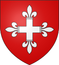 | The arms of Yquebeuf are blazoned : Gules, a cross fleury argent.
|
Population
| Year | Pop. | ±% p.a. |
|---|---|---|
| 1968 | 119 | — |
| 1975 | 123 | +0.47% |
| 1982 | 180 | +5.59% |
| 1990 | 224 | +2.77% |
| 1999 | 218 | −0.30% |
| 2007 | 242 | +1.31% |
| 2012 | 255 | +1.05% |
| 2017 | 238 | −1.37% |
| 2020 | 240 | +0.28% |
| Source: INSEE[3] | ||
Places of interest
- The church of St. Etienne, dating from the eighteenth century.
- The church of St. Laurent, dating from the seventeenth century.
See also
References
- ^ "Répertoire national des élus: les maires". data.gouv.fr, Plateforme ouverte des données publiques françaises (in French). 2 December 2020.
- ^ "Populations légales 2021". The National Institute of Statistics and Economic Studies. 28 December 2023.
- ^ Population en historique depuis 1968, INSEE
External links
Wikimedia Commons has media related to Yquebeuf.
- Official commune website (in French)
- v
- t
- e
Communes of the Seine-Maritime department 

- Allouville-Bellefosse
- Alvimare
- Ambrumesnil
- Amfreville-la-Mi-Voie
- Amfreville-les-Champs
- Anceaumeville
- Ancourt
- Ancourteville-sur-Héricourt
- Ancretiéville-Saint-Victor
- Ancretteville-sur-Mer
- Angerville-Bailleul
- Angerville-la-Martel
- Angerville-l'Orcher
- Angiens
- Anglesqueville-l'Esneval
- Anglesqueville-la-Bras-Long
- Anneville-Ambourville
- Anneville-sur-Scie
- Annouville-Vilmesnil
- Anquetierville
- Anvéville
- Ardouval
- Arelaune-en-Seine
- Argueil
- Arques-la-Bataille
- Aubéguimont
- Aubermesnil-aux-Érables
- Aubermesnil-Beaumais
- Auberville-la-Manuel
- Auberville-la-Renault
- Aumale
- Auppegard
- Authieux-Ratiéville
- Les Authieux-sur-le-Port-Saint-Ouen
- Autigny
- Auvilliers
- Auzebosc
- Auzouville-l'Esneval
- Auzouville-sur-Ry
- Auzouville-sur-Saâne
- Avesnes-en-Bray
- Avesnes-en-Val
- Avremesnil
- Bacqueville-en-Caux
- Bailleul-Neuville
- Baillolet
- Bailly-en-Rivière
- Baons-le-Comte
- Bardouville
- Barentin
- Baromesnil
- Bazinval
- Beaubec-la-Rosière
- Beaumont-le-Hareng
- Beaurepaire
- Beaussault
- Beautot
- Beauval-en-Caux
- Beauvoir-en-Lyons
- Bec-de-Mortagne
- Belbeuf
- Bellencombre
- Bellengreville
- Belleville-en-Caux
- La Bellière
- Belmesnil
- Bénarville
- Bénesville
- Bénouville
- Bernières
- Bertheauville
- Bertreville
- Bertreville-Saint-Ouen
- Bertrimont
- Berville-en-Caux
- Berville-sur-Seine
- Beuzeville-la-Grenier
- Beuzeville-la-Guérard
- Beuzevillette
- Bézancourt
- Bierville
- Bihorel
- Biville-la-Baignarde
- Biville-la-Rivière
- Blacqueville
- Blainville-Crevon
- Blangy-sur-Bresle
- Blosseville
- Le Bocasse
- Bois-d'Ennebourg
- Bois-Guilbert
- Bois-Guillaume
- Bois-Héroult
- Bois-Himont
- Bois-l'Évêque
- Le Bois-Robert
- Boissay
- Bolbec
- Bolleville
- Bonsecours
- Boos
- Bordeaux-Saint-Clair
- Bornambusc
- Bosc-Bérenger
- Bosc-Bordel
- Bosc-Édeline
- Bosc-Guérard-Saint-Adrien
- Bosc-Hyons
- Bosc-le-Hard
- Bosc-Mesnil
- Bosville
- Boudeville
- Bouelles
- La Bouille
- Bourdainville
- Le Bourg-Dun
- Bourville
- Bouville
- Brachy
- Bracquetuit
- Bradiancourt
- Brametot
- Bréauté
- Brémontier-Merval
- Bretteville-du-Grand-Caux
- Bretteville-Saint-Laurent
- Buchy
- Bully
- Bures-en-Bray
- Butot
- Butot-Vénesville
- Cailleville
- Cailly
- Callengeville
- Calleville-les-Deux-Églises
- Campneuseville
- Canehan
- Canouville
- Canteleu
- Canville-les-Deux-Églises
- Cany-Barville
- Carville-la-Folletière
- Carville-Pot-de-Fer
- Le Catelier
- Catenay
- Caudebec-lès-Elbeuf
- Le Caule-Sainte-Beuve
- Cauville-sur-Mer
- Les Cent-Acres
- La Cerlangue
- La Chapelle-du-Bourgay
- La Chapelle-Saint-Ouen
- La Chapelle-sur-Dun
- La Chaussée
- Cideville
- Clais
- Clasville
- Claville-Motteville
- Cléon
- Clères
- Cleuville
- Cléville
- Cliponville
- Colleville
- Colmesnil-Manneville
- Compainville
- Conteville
- Contremoulins
- Cottévrard
- Crasville-la-Mallet
- Crasville-la-Rocquefort
- Criel-sur-Mer
- La Crique
- Criquebeuf-en-Caux
- Criquetot-l'Esneval
- Criquetot-le-Mauconduit
- Criquetot-sur-Longueville
- Criquetot-sur-Ouville
- Criquiers
- Critot
- Croisy-sur-Andelle
- Croixdalle
- Croix-Mare
- Cropus
- Crosville-sur-Scie
- Cuverville
- Cuverville-sur-Yères
- Cuy-Saint-Fiacre
- Dampierre-en-Bray
- Dampierre-Saint-Nicolas
- Dancourt
- Darnétal
- Daubeuf-Serville
- Dénestanville
- Déville-lès-Rouen
- Dieppesubpr
- Doudeauville
- Doudeville
- Douvrend
- Drosay
- Duclair
- Écalles-Alix
- Écrainville
- Écretteville-lès-Baons
- Écretteville-sur-Mer
- Ectot-l'Auber
- Ectot-lès-Baons
- Elbeuf
- Elbeuf-en-Bray
- Elbeuf-sur-Andelle
- Életot
- Ellecourt
- Émanville
- Envermeu
- Envronville
- Épinay-sur-Duclair
- Épouville
- Épretot
- Épreville
- Ermenouville
- Ernemont-la-Villette
- Ernemont-sur-Buchy
- Esclavelles
- Eslettes
- Esteville
- Étaimpuis
- Étainhus
- Étalleville
- Étalondes
- Étoutteville
- Étretat
- Eu
- Fallencourt
- Fécamp
- Ferrières-en-Bray
- La Ferté-Saint-Samson
- Fesques
- La Feuillie
- Flamanville
- Flamets-Frétils
- Flocques
- Fongueusemare
- Fontaine-en-Bray
- Fontaine-la-Mallet
- Fontaine-le-Bourg
- Fontaine-le-Dun
- Fontaine-sous-Préaux
- La Fontelaye
- Fontenay
- Forges-les-Eaux
- Foucarmont
- Foucart
- Franqueville-Saint-Pierre
- Fréauville
- La Frénaye
- Freneuse
- Fresles
- Fresnay-le-Long
- Fresne-le-Plan
- Fresnoy-Folny
- Fresquiennes
- Freulleville
- Frichemesnil
- Froberville
- Fry
- Fultot
- La Gaillarde
- Gaillefontaine
- Gainneville
- Gancourt-Saint-Étienne
- Ganzeville
- Gerponville
- Gerville
- Goderville
- Gommerville
- Gonfreville-Caillot
- Gonfreville-l'Orcher
- Gonnetot
- Gonneville-la-Mallet
- Gonneville-sur-Scie
- Gonzeville
- Goupillières
- Gournay-en-Bray
- Gouy
- Graimbouville
- Grainville-la-Teinturière
- Grainville-sur-Ry
- Grainville-Ymauville
- Grand-Camp
- Grand-Couronne
- Grandcourt
- Les Grandes-Ventes
- Le Grand-Quevilly
- Graval
- Grèges
- Grémonville
- Greuville
- Grigneuseville
- Gruchet-le-Valasse
- Gruchet-Saint-Siméon
- Grugny
- Grumesnil
- Guerville
- Gueures
- Gueutteville
- Gueutteville-les-Grès
- La Hallotière
- Le Hanouard
- Harcanville
- Harfleur
- Hattenville
- Haucourt
- Haudricourt
- Haussez
- Hautot-l'Auvray
- Hautot-le-Vatois
- Hautot-Saint-Sulpice
- Hautot-sur-Mer
- Hautot-sur-Seine
- Les Hauts-de-Caux
- Le Havresubpr
- La Haye
- Héberville
- Hénouville
- Héricourt-en-Caux
- Hermanville
- Hermeville
- Le Héron
- Héronchelles
- Heugleville-sur-Scie
- Heuqueville
- Heurteauville
- Hodeng-au-Bosc
- Hodeng-Hodenger
- Houdetot
- Le Houlme
- Houppeville
- Houquetot
- La Houssaye-Béranger
- Hugleville-en-Caux
- Les Ifs
- Illois
- Imbleville
- Incheville
- Ingouville
- Isneauville
- Jumièges
- Lamberville
- Lammerville
- Landes-Vieilles-et-Neuves
- Lanquetot
- Lestanville
- Lillebonne
- Limésy
- Limpiville
- Lindebeuf
- Lintot
- Lintot-les-Bois
- Les Loges
- La Londe
- Londinières
- Longmesnil
- Longroy
- Longueil
- Longuerue
- Longueville-sur-Scie
- Louvetot
- Lucy
- Luneray
- Malaunay
- Malleville-les-Grès
- Manéglise
- Manéhouville
- Maniquerville
- Manneville-ès-Plains
- Manneville-la-Goupil
- Mannevillette
- Maromme
- Marques
- Martainville-Épreville
- Martigny
- Martin-Église
- Massy
- Mathonville
- Maucomble
- Maulévrier-Sainte-Gertrude
- Mauny
- Mauquenchy
- Mélamare
- Melleville
- Ménerval
- Ménonval
- Mentheville
- Mésangueville
- Mesnières-en-Bray
- Le Mesnil-Durdent
- Le Mesnil-Esnard
- Mesnil-Follemprise
- Le Mesnil-Lieubray
- Mesnil-Mauger
- Mesnil-Panneville
- Mesnil-Raoul
- Le Mesnil-Réaume
- Le Mesnil-sous-Jumièges
- Meulers
- Millebosc
- Mirville
- Molagnies
- Monchaux-Soreng
- Monchy-sur-Eu
- Mont-Cauvaire
- Mont-Saint-Aignan
- Montérolier
- Montigny
- Montivilliers
- Montmain
- Montreuil-en-Caux
- Montroty
- Montville
- Morgny-la-Pommeraye
- Morienne
- Mortemer
- Morville-sur-Andelle
- Motteville
- Moulineaux
- Muchedent
- Nesle-Hodeng
- Nesle-Normandeuse
- Neufbosc
- Neufchâtel-en-Bray
- Neuf-Marché
- La Neuville-Chant-d'Oisel
- Neuville-Ferrières
- Néville
- Nointot
- Nolléval
- Normanville
- Norville
- Notre-Dame-d'Aliermont
- Notre-Dame-de-Bliquetuit
- Notre-Dame-de-Bondeville
- Notre-Dame-du-Bec
- Notre-Dame-du-Parc
- Nullemont
- Ocqueville
- Octeville-sur-Mer
- Offranville
- Oherville
- Oissel
- Omonville
- Orival
- Osmoy-Saint-Valery
- Ouainville
- Oudalle
- Ourville-en-Caux
- Ouville-l'Abbaye
- Ouville-la-Rivière
- Paluel
- Parc-d'Anxtot
- Pavilly
- Petit-Caux
- Petit-Couronne
- Le Petit-Quevilly
- Petiville
- Pierrecourt
- Pierrefiques
- Pierreval
- Pissy-Pôville
- Pleine-Sève
- Pommereux
- Pommeréval
- Ponts-et-Marais
- Port-Jérôme-sur-Seine
- La Poterie-Cap-d'Antifer
- Préaux
- Prétot-Vicquemare
- Preuseville
- Puisenval
- Quevillon
- Quévreville-la-Poterie
- Quiberville
- Quièvrecourt
- Quincampoix
- Raffetot
- Rainfreville
- Réalcamp
- Rebets
- La Remuée
- Rétonval
- Reuville
- Ricarville-du-Val
- Richemont
- Rieux
- Rives-en-Seine
- Riville
- Robertot
- Rocquefort
- Rocquemont
- Rogerville
- Rolleville
- Roncherolles-en-Bray
- Roncherolles-sur-le-Vivier
- Ronchois
- Rosay
- Rouenpref
- Roumare
- Routes
- Rouville
- Rouvray-Catillon
- Rouxmesnil-Bouteilles
- Royville
- La Rue-Saint-Pierre
- Ry
- Saâne-Saint-Just
- Sahurs
- Sainneville
- Saint-Aignan-sur-Ry
- Saint-André-sur-Cailly
- Saint-Antoine-la-Forêt
- Saint-Arnoult
- Saint-Aubin-Celloville
- Saint-Aubin-de-Crétot
- Saint-Aubin-Épinay
- Saint-Aubin-le-Cauf
- Saint-Aubin-lès-Elbeuf
- Saint-Aubin-Routot
- Saint-Aubin-sur-Mer
- Saint-Aubin-sur-Scie
- Saint-Clair-sur-les-Monts
- Saint-Crespin
- Saint-Denis-d'Aclon
- Saint-Denis-le-Thiboult
- Saint-Denis-sur-Scie
- Sainte-Adresse
- Sainte-Agathe-d'Aliermont
- Sainte-Austreberthe
- Sainte-Beuve-en-Rivière
- Sainte-Colombe
- Sainte-Croix-sur-Buchy
- Sainte-Foy
- Sainte-Geneviève
- Sainte-Hélène-Bondeville
- Sainte-Marguerite-sur-Duclair
- Sainte-Marguerite-sur-Mer
- Sainte-Marie-au-Bosc
- Sainte-Marie-des-Champs
- Saint-Étienne-du-Rouvray
- Saint-Eustache-la-Forêt
- Saint-Georges-sur-Fontaine
- Saint-Germain-des-Essourts
- Saint-Germain-d'Étables
- Saint-Germain-sous-Cailly
- Saint-Germain-sur-Eaulne
- Saint-Gilles-de-Crétot
- Saint-Gilles-de-la-Neuville
- Saint-Hellier
- Saint-Honoré
- Saint-Jacques-d'Aliermont
- Saint-Jacques-sur-Darnétal
- Saint-Jean-de-Folleville
- Saint-Jean-de-la-Neuville
- Saint-Jean-du-Cardonnay
- Saint-Jouin-Bruneval
- Saint-Laurent-de-Brèvedent
- Saint-Laurent-en-Caux
- Saint-Léger-aux-Bois
- Saint-Léger-du-Bourg-Denis
- Saint-Léonard
- Saint-Lucien
- Saint-Maclou-de-Folleville
- Saint-Maclou-la-Brière
- Saint-Mards
- Saint-Martin-au-Bosc
- Saint-Martin-aux-Arbres
- Saint-Martin-aux-Buneaux
- Saint-Martin-de-Boscherville
- Saint-Martin-de-l'If
- Saint-Martin-du-Bec
- Saint-Martin-du-Manoir
- Saint-Martin-du-Vivier
- Saint-Martin-le-Gaillard
- Saint-Martin-l'Hortier
- Saint-Martin-Osmonville
- Saint-Maurice-d'Ételan
- Saint-Michel-d'Halescourt
- Saint-Nicolas-d'Aliermont
- Saint-Nicolas-de-la-Haie
- Saint-Nicolas-de-la-Taille
- Saint-Ouen-du-Breuil
- Saint-Ouen-le-Mauger
- Saint-Ouen-sous-Bailly
- Saint-Paër
- Saint-Pierre-Bénouville
- Saint-Pierre-de-Manneville
- Saint-Pierre-des-Jonquières
- Saint-Pierre-de-Varengeville
- Saint-Pierre-en-Port
- Saint-Pierre-en-Val
- Saint-Pierre-lès-Elbeuf
- Saint-Pierre-le-Vieux
- Saint-Pierre-le-Viger
- Saint-Rémy-Boscrocourt
- Saint-Riquier-en-Rivière
- Saint-Riquier-ès-Plains
- Saint-Romain-de-Colbosc
- Saint-Saëns
- Saint-Saire
- Saint-Sauveur-d'Émalleville
- Saint-Sylvain
- Saint-Vaast-d'Équiqueville
- Saint-Vaast-Dieppedalle
- Saint-Vaast-du-Val
- Saint-Valery-en-Caux
- Saint-Victor-l'Abbaye
- Saint-Vigor-d'Ymonville
- Saint-Vincent-Cramesnil
- Sandouville
- Sassetot-le-Malgardé
- Sassetot-le-Mauconduit
- Sasseville
- Sauchay
- Saumont-la-Poterie
- Sauqueville
- Saussay
- Sausseuzemare-en-Caux
- Senneville-sur-Fécamp
- Sept-Meules
- Serqueux
- Servaville-Salmonville
- Sierville
- Sigy-en-Bray
- Smermesnil
- Sommery
- Sommesnil
- Sorquainville
- Sotteville-lès-Rouen
- Sotteville-sous-le-Val
- Sotteville-sur-Mer
- Tancarville
- Terres-de-Caux
- Thérouldeville
- Theuville-aux-Maillots
- Thiergeville
- Thiétreville
- Thil-Manneville
- Le Thil-Riberpré
- Thiouville
- Le Tilleul
- Tocqueville-en-Caux
- Tocqueville-les-Murs
- Torcy-le-Grand
- Torcy-le-Petit
- Le Torp-Mesnil
- Tôtes
- Touffreville-la-Corbeline
- Touffreville-sur-Eu
- Tourville-la-Rivière
- Tourville-les-Ifs
- Tourville-sur-Arques
- Toussaint
- Le Trait
- Trémauville
- Le Tréport
- La Trinité-du-Mont
- Les Trois-Pierres
- Trouville
- Turretot
- Val-de-la-Haye
- Val-de-Saâne
- Val-de-Scie
- Valliquerville
- Valmont
- Varengeville-sur-Mer
- Varneville-Bretteville
- Vassonville
- Vatierville
- Vattetot-sous-Beaumont
- Vattetot-sur-Mer
- Vatteville-la-Rue
- La Vaupalière
- Veauville-lès-Quelles
- Vénestanville
- Ventes-Saint-Rémy
- Vergetot
- Veules-les-Roses
- Veulettes-sur-Mer
- Vibeuf
- Vieux-Manoir
- Vieux-Rouen-sur-Bresle
- La Vieux-Rue
- Villainville
- Villers-Écalles
- Villers-sous-Foucarmont
- Villy-sur-Yères
- Vinnemerville
- Virville
- Vittefleur
- Wanchy-Capval
- Yainville
- Yébleron
- Yerville
- Ymare
- Yport
- Ypreville-Biville
- Yquebeuf
- Yvecrique
- Yvetot
- Yville-sur-Seine
- pref: prefecture
- subpr: subprefecture
| Authority control databases: National |
|
|---|
This Rouen geographical article is a stub. You can help Wikipedia by expanding it. |
- v
- t
- e


