Yangbajain
Place in Tibet Autonomous Region, China
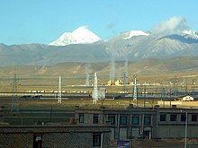
30°5′N 90°33′E / 30.083°N 90.550°E / 30.083; 90.550Yangbajain (also spelled Yangbajing; Chinese: 羊八井; pinyin: Yángbājǐng) is a town approximately 87 kilometers (54 mi) north-west of Lhasa, halfway to Damxung in the Tibet Autonomous Region of China. The town lies just south of the Nyainqêntanglha Mountains, in an upland lush green valley surrounded by the tents of nomads with grazing yak and sheep populating the hillside. It is the site Yangpachen Monastery, which was historically the seat of the Shamarpas of Karma Kagyü and the Yangbajing International Cosmic Ray Observatory.
Geothermal field
The area is famous for the Yangbajain Geothermal Field, which has been harnessed to produce electricity for the capital Lhasa. There is a thermoelectric power plant on the edge of the Yangbajain field covering 20–30 square kilometers.[1] The power plant was established in 1977, and was the first development of geothermal power not only in Tibet but in the whole of China.
The Yangbajain hot springs field is at an elevation of 4,290 to 4,500 metres (14,070 to 14,760 ft)[2] which makes it the highest elevation set of hot springs in China, and possibly the world.[3] The highest temperature inside the drilling hole is 125.5°C.[4]
Holy Medical Spring Resort
The Holy Medical Spring Resort has both two indoor swimming pools and one outdoor swimming pool, all filled with hot springs water.[4] Bathing is allowed at an elevation of 4200m AMSL, likely making it the highest swimming pool in the world.
Yangbajing International Cosmic Ray Observatory
The YBJ International Cosmic Ray Observatory (羊八井国际宇宙线观测站) is located in the Yangbajing valley of the Tibetan highland, a site chosen for its high elevation at 4300 meters above sea level.[5] Collaborating institutes includes the INFN (Istituto Nazionale di Fisica Nucleare) and various Chinese and Japanese universities.[6] [7] The KOSMA 3-m submillimeter telescope has been relocated to a nearby site and renamed CCOSMA.
See also
References
- ^ Geography
- ^ Forecast and evaluation of hot dry rock geothermal resource in China, Zhijun Wan, Yangsheng Zhao and Jianrong Kang, Renewable Energy, Volume 30, Issue 12 , October 2005, Pages 1831-1846.
- ^ Chinese cultural organization site making claim that these are the highest altitude hot springs in the world Archived 2016-01-10 at the Wayback Machine
- ^ a b 安才旦 (2003). Travel guide to Tibet of China. China Intercontinental Press. p. 28. ISBN 9787508503745. Retrieved 2010-11-30.
- ^ "羊八井国际宇宙线观测站主页". 高能所网. 2005-09-26. Retrieved July 29, 2008.
- ^ "The ARGO-YBJ Experiment". INFN. 2008-12-03. Retrieved January 29, 2009.
- ^ "The Tibet ASgamma Collaboration". ICRR. 2008-02-02. Retrieved January 29, 2009.
- v
- t
- e
Township-level divisions of Lhasa
- Caigungtang Subdistrict
- Chabxi Subdistrict
- Garmagoinsar Subdistrict
- Gündêling Subdistrict
- Gyirai Subdistrict
- Jêbumgang Subdistrict
- Jinzhu West Road Subdistrict
- Liangdao Subdistrict
- Ngaqên Subdistrict
- Nyangrain Subdistrict
- Pargor Subdistrict
- Togdê Subdistrict
- Donggar Subdistrict
- Liuwu (Niu) Subdistrict
- Naiqung Subdistrict
- Yamda Subdistrict
- Dêqên Township
- Gurum Township
- Mar Township
- Dêqên town
- Bomtoi Township
- Targyai Township
- Tanggar Township
- Xog Township
- Zangdog Township
- Gandainqoikor town
- Banjorling Township
- Codoi Township
- Jangraxar Township
- Karzê Township
- Ngarnang Township
- Pondo Township
- Qangka Township
- Songpan Township
- Tanggo Township
- Damquka town
- Yangbajain town
- Gongtang Township
- Gyaidar Township
- Lungring Township
- Namco Township
- Nyingzhong Township
- Wumatang Township
- Tarchong town
- Karru Township
- Margyang Township
- Nyêmo Township
- Paggor Township
- Pusum Township
- Toinba Township
- Xumai Township
- Qüxü town
- Caina Township
- Carbanang Township
- Dagar Township
- Nam Township
- Nyêtang Township
- Kunggar town
- Gyama Township
- Mamba Township
- Nyimajangra Township
- Rutog Township
- Tanggya Township
- Zaxoi Township
- Zhaxigang Township


Portals:
 China
China Astronomy
 Stars
Stars Geography
 Education
 Science


30°5′N 90°33′E / 30.083°N 90.550°E / 30.083; 90.550


