White Rock Forge Covered Bridge
Bridge in Pennsylvania, United States
39°49′29″N 76°05′24″W / 39.8247°N 76.0900°W / 39.8247; -76.0900
The White Rock Forge Covered Bridge or White Rock Covered Bridge is a covered bridge that spans the West Branch of the Octoraro Creek in southeast Lancaster County, Pennsylvania. A county-owned and maintained bridge, its official designation is the West Octoraro #2 Bridge.[1] It was first built in 1847 by John Russell and Elias McMellen, but the original was destroyed and last rebuilt in 1884. The wooden burr bridge crosses the West Branch of the Octoraro Creek. It is 103 feet long and 13 feet wide.
The bridge has a single span, wooden, double Burr arch trusses design with the addition of steel hanger rods. The deck is made from oak planks.[1] It is painted red, the traditional color of Lancaster County covered bridges, on both the inside and outside. Both approaches to the bridge are painted in the traditional white color.
The bridge's WGCB Number is 38-36-18. Added in 1980, it is listed on the National Register of Historic Places as structure number 80003522.[2] It is located at 39°49′28.8″N 76°5′24″W / 39.824667°N 76.09000°W / 39.824667; -76.09000 (39.82467, -76.09000).[3]
Dimensions
- Length: 103 feet (31.4 m) span and 110 feet (33.5 m) total length
- Width: 13 feet (4.0 m) clear deck and 15 feet (4.6 m) total width
- Overhead clearance: 12 feet (3.7 m)
- Underclearance: 13 feet (4.0 m)
Gallery
-
 White Rock Forge covered bridge
 -
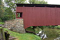
 Side view of the bridge
 -
 Window in the side of the bridge
 -
 Side view of the bridge showing its underside
 -
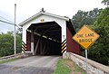 One of the approaches to the bridge
 -
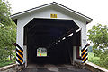 The other approach
 -
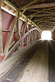
 The inside of the bridge showing the Burr arch truss design
 -
 Closeup of the Burr arch truss


See also
- Burr arch truss
- List of Lancaster County covered bridges
References
- McCain, Dr. Roger A. "White Rock Bridge". A Guide to Old Covered Bridges of Southeastern Pennsylvania and nearby areas. Retrieved 2006-08-04.
- "White Rock Forge Covered Bridge". Lancaster County Pennsylvania Dutch Country Official Visitors Center. Pennsylvania Dutch Convention & Visitors Bureau. 2006. Retrieved 2006-07-07.
- ^ a b "White Rock Forge Covered Bridge". Lancaster County, PA Government Portal. County of Lancaster, Pennsylvania. 2001-10-20. Retrieved 2006-07-07.
- ^ "PENNSYLVANIA - Lancaster County". National Register of Historic Places. Retrieved 2007-03-20.
- ^ Travis, Dale. "38-36-18". Round Barns & Covered Bridges. Retrieved 2006-08-08.
External links
Wikimedia Commons has media related to White Rock Forge Covered Bridge.
- v
- t
- e
- Contributing property
- Keeper of the Register
- Historic district
- History of the National Register of Historic Places
- National Park Service
- Property types

- Adams
- Allegheny
- Armstrong
- Beaver
- Bedford
- Berks
- Blair
- Bradford
- Bucks
- Butler
- Cambria
- Cameron
- Carbon
- Centre
- Chester
- Clarion
- Clearfield
- Clinton
- Columbia
- Crawford
- Cumberland
- Dauphin
- Delaware
- Elk
- Erie
- Fayette
- Forest
- Franklin
- Fulton
- Greene
- Huntingdon
- Indiana
- Jefferson
- Juniata
- Lackawanna
- Lancaster
- Lawrence
- Lebanon
- Lehigh
- Luzerne
- Lycoming
- McKean
- Mercer
- Mifflin
- Monroe
- Montgomery
- Montour
- Northampton
- Northumberland
- Perry
- Philadelphia
- Pike
- Potter
- Schuylkill
- Snyder
- Somerset
- Sullivan
- Susquehanna
- Tioga
- Union
- Venango
- Warren
- Washington
- Wayne
- Westmoreland
- Wyoming
- York
 Category
 NRHP portal


