Westvoorne
Island municipality in South Holland province, Netherlands
Former municipality in South Holland, Netherlands
Flag

Coat of arms

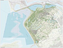
Location in South Holland
(January 2021)[3]
3233–3235
Westvoorne is a former municipality on the island of Voorne-Putten in the western Netherlands, in the province of South Holland. The former municipality covered an area of 97.48 km2 (37.64 sq mi) of which 44.30 km2 (17.10 sq mi) was water. It had a population of 14,900 in 2021.
The municipality of Westvoorne was formed on 1 January 1980, through the merger of the former municipalities of Oostvoorne and Rockanje.[4] It consisted of the population centres of Oostvoorne, Rockanje, Tinte and Helhoek.
On 1 January 2023, the municipality of Westvoorne merged with Brielle and Hellevoetsluis into the new municipality of Voorne aan Zee.
Trivia
In 2011, Westvoorne received the QualityCoast Gold Award for its efforts to become a sustainable tourism destination. Because of this award Westvoorne had been selected for inclusion in the global atlas for sustainable tourism DestiNet.[5]
Notable people
- Jacob van Maerlant (ca.1230–40 – ca.1288–1300) Flemish poet of the 13th century, an important Middle Dutch author of the Middle Ages
- Volkert Simon Maarten van der Willigen (1822–1878) Dutch mathematician, physicist and professor
- Belinda Meuldijk (born 1955) Dutch actress, writer, and activist [6]
- Meindert van Buuren (born 1995) Dutch racing driver
Gallery
-
 Tinte, chapel
 -
 Rockanje, windmill
 -
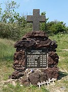 Tweede Slag, Rockanje. Oorlogsmonument in de duinen


References
- ^ "Kerncijfers wijken en buurten 2020" [Key figures for neighbourhoods 2020]. StatLine (in Dutch). CBS. 24 July 2020. Retrieved 19 September 2020.
- ^ "Postcodetool for 3235AP". Actueel Hoogtebestand Nederland (in Dutch). Het Waterschapshuis. Retrieved 29 August 2013.
- ^ "Bevolkingsontwikkeling; regio per maand" [Population growth; regions per month]. CBS Statline (in Dutch). CBS. 1 January 2021. Retrieved 2 January 2022.
- ^ Ad van der Meer and Onno Boonstra, Repertorium van Nederlandse gemeenten, KNAW, 2011.
- ^ Sustainable Tourism Destination EUCC
- ^ IMDb Database retrieved 31 May 2019
External links
- Official website
Places adjacent to Westvoorne | ||||||||||||||||
|---|---|---|---|---|---|---|---|---|---|---|---|---|---|---|---|---|
| ||||||||||||||||


Authority control databases | |
|---|---|
| International |
|
| National |
|
- v
- t
- e


