Traill Island
72°32′N 23°10′W / 72.533°N 23.167°W / 72.533; -23.167Area 3,452 km2 (1,333 sq mi) Area rank 4th largest in Greenland
153rd largest in world Highest elevation 1,884 m (6181 ft)[1] Highest point Unnamed Administration Unincorporated area NE Greenland National Park Demographics Population 0 (2021) Pop. density 0/km2 (0/sq mi) Ethnic groups none
153rd largest in world
Greenland
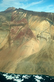
Traill Island (Danish: Traill Ø) is a large island in eastern Greenland. It is named after zoologist Thomas Stewart Traill. The island is a part of the Northeast Greenland National Park.
Geography
Traill Island is a coastal island located in the desolate region of Eastern Greenland on the eastern side of King Oscar Fjord, northeast of Davy Sound. Geographical Society Island lies to the north, separated by a narrow channel, the Vega Sound.
The southernmost point of the island is Cape Simpson. Dream Bay (Drømmebugten) is located 14 km (8.7 mi) WNW of the headland and larger Mountnorris Fjord to the northeast.[2]
The highest summit of the island, a 1,884 metres (6,181 feet) high unnamed peak of the Svinhufvud Range is one of the ultra-prominent summits of Greenland.
 |
See also
References
External links
 Media related to Traill Island at Wikimedia Commons


