Staufenberg, Lower Saxony
Municipality in Lower Saxony, Germany

Coat of arms
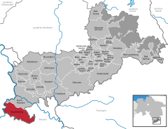
Location of Staufenberg within Göttingen district
(2021–26) Bernd Grebenstein[1]
(2022-12-31)[2]
34355
Staufenberg is the southernmost municipality of the district of Göttingen, and of Lower Saxony, Germany. It is situated east of the river Fulda, approx. 6 km south of Hannoversch Münden, and 12 km northeast of Kassel. Its seat is in the village Landwehrhagen.
Points of interest
- Arboretum Habichtsborn
References
- ^ "Direktwahlen in Niedersachsen vom 12. September 2021" (PDF). Landesamt für Statistik Niedersachsen. 13 October 2021.
- ^ "LSN-Online Regionaldatenbank, Tabelle A100001G: Fortschreibung des Bevölkerungsstandes, Stand 31. Dezember 2022" (in German). Landesamt für Statistik Niedersachsen.
- v
- t
- e
Towns and municipalities in Göttingen (district)
- Adelebsen
- Bad Grund
- Bad Lauterberg
- Bad Sachsa
- Bilshausen
- Bodensee
- Bovenden
- Bühren
- Dransfeld
- Duderstadt
- Ebergötzen
- Elbingerode
- Friedland
- Gieboldehausen
- Gleichen
- Göttingen
- Hann. Münden
- Hattorf am Harz
- Herzberg am Harz
- Hörden am Harz
- Jühnde
- Krebeck
- Landolfshausen
- Niemetal
- Obernfeld
- Osterode am Harz
- Rhumspringe
- Rollshausen
- Rosdorf
- Rüdershausen
- Scheden
- Seeburg
- Seulingen
- Staufenberg
- Waake
- Walkenried
- Wollbrandshausen
- Wollershausen
- Wulften am Harz

Authority control databases | |
|---|---|
| International |
|
| National |
|
 | This Göttingen district location article is a stub. You can help Wikipedia by expanding it. |
- v
- t
- e


