Southeast Metro Manila Expressway
Highway under construction in the Philippines
 | |
|---|---|
| Skyway Stage 4 C6 Expressway | |
 | |
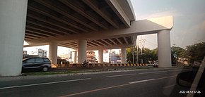 Construction along Carlos P. Garcia Avenue (C-5) in Taguig as of August 2022 | |
| Route information | |
| Maintained by SMC Skyway Stage 4 Corporation[1] | |
| Length | 32.664 km[2] (20.296 mi) |
| Component highways | |
| Major junctions | |
| South end |  AH 26 (E2) (Skyway) at Taguig–Parañaque boundary AH 26 (E2) (Skyway) at Taguig–Parañaque boundary |
| North end | Batasan Road in Quezon City |
| Location | |
| Country | Philippines |
| Major cities |
|
| Towns |
|
| Highway system | |
| |
The Southeast Metro Manila Expressway (SEMME), also known as Skyway Stage 4, C-6 Expressway and formerly as Metro Manila Expressway, is an on-hold[5][6] 32.664-kilometer (20.296 mi)[2] tolled expressway running across eastern Metro Manila and western Rizal. The expressway will help decongest the existing roadways across Metro Manila, such as EDSA and Circumferential Road 5. The expressway is part of the larger Circumferential Road 6 project. Which it's expansion from original C-6 length currently passing from General Santos Avenue in Taguig up to Highway 2000 (Phase 1) in Taytay, will expand to Cainta, Marikina, San Mateo, and in Quezon City.
The expressway will begin at the Skyway near FTI (now Arca South), Taguig, and will end at the Batasang Pambansa Complex in Quezon City. It will also connect to the North Luzon Expressway (NLEx) in Balagtas, Bulacan.[7]

The entire expressway will be a spur component of Expressway 2 (E2) of the Philippine expressway network.
History
In 1945, the Metropolitan Thoroughfare Plan was submitted by Quezon City planners Louis Croft and Antonio Kayanan, which proposed the laying of 10 radial roads to convey traffic in and out of the city of Manila to the surrounding cities and provinces and the completion of six circumferential roads that will act as beltways of the city, forming altogether a web-like arterial road system, including the sixth circumferential road, which runs from Meycauayan to Las Pinas. 28 years later, in the Urban Transportation Study in Manila Metropolitan Area (UTSMMA), it was proposed that the construction of the highway between Navotas and Las Pinas.[8]
In 1983, under the administration of President Ferdinand Marcos, it was proposed that the highway would be a tolled expressway known as the Metro Manila Expressway (MME), and the route would begin at the North Luzon Expressway in Meycauayan and end at the South Luzon Expressway in Bicutan, Paranaque. The total length is approximately 44.570 km. The plan was undertaken by the Philippine National Construction Corporation (PNCC).[9] The proposal was revived again in 1993, when PNCC signed an agreement to build the expressway with PT Citra Lamtoro Gung Persada (CITRA) of Indonesia.[10]
The agreement was supplemented on February 14, 1994, with a related undertaking on the part of CITRA. CITRA was to provide a preliminary feasibility study on the Metro Manila Skyways (MMS) project, a system of elevated roadway networks passing through the heart of the Metropolitan Manila area. In order to accelerate the actual implementation of both the MME and the MMS projects, PNCC and CITRA entered into a second agreement. Through that agreement, CITRA committed to finance and undertake the preparation, updating, and revalidation of previous studies on the construction, operation, and maintenance of the projects.[11] According to the CITRA proposal, the planned alignment was to have 38.4 kilometers from Meycauayan to Bicutan, also the same route as the 1983 plan, while the remaining segments leading to San Pedro were 18 kilometers and 19 kilometers to Cavite.[12]
In the late 2000s proposal, the Circumferential Road involves a 59.5-kilometer tollway that links the North and South Luzon Expressways via the towns of Rizal and the eastern parts of Metro Manila. This tollway will traverse the cities of San Jose Del Monte City in Bulacan and Antipolo City in Rizal; Marikina City; Taguig City; and Muntinlupa City. It shall also pass through the towns of Rodriguez/Montalban, San Mateo, Taytay, and Angono in Rizal; Bacoor, Imus, Kawit, and Noveleta in Cavite.[13] The C-6 project was also included in the 2010 Japan International Cooperation Agency (JICA) study on the High Standard Highway master plan, the feasibility study undertaken by the Ministry of Economy, Trade, and Industry and the Japan External Trade Organization in 2008, and another study by the Korean International Cooperation Agency with a full-scale FS.
The plan was launched again in 2014 by Citra and PNCC, as well as San Miguel Corporation. The Metro Manila Expressway, or C-6 Project, is actually Stage 4 of the South Metro Manila Skyway (SMMS). This toll road will stretch from Bicutan to San Jose Del Monte and will then connect to the proposed MRT-7 Project, which will extend to the NLEX. The toll road will have a length of 34.33 km, 7.62 km of which is the elevated portion, six (6) lanes with six (6) interchanges and 20 ramps, and a close toll collection system. The construction cost is estimated at P19.76 billion out of the total P29.84 billion project cost. The Restated Supplement to the Business and Joint Venture Agreement (Restated Supplement to BJVA) for the MME Project, executed in January 2014, contains the agreement of the parties and embodies the terms and conditions for MME.[14]
Groundbreaking ceremony of the project was held on January 8, 2018.[7] The project was scheduled to be completed in 2022, but construction was delayed due to right-of-way issues at the affected properties in Taguig and Rizal. Since then, no progress has been made as of 2024, with an elevated portion erected above the C-5/Bayani Road interchange.
Future exits
Exits will be numbered by kilometer posts, with Rizal Park in Manila designated as kilometer zero.
| Region | Province | City/Municipality | km | mi | Exit | Name | Destinations | Notes |
|---|---|---|---|---|---|---|---|---|
| Metro Manila | Taguig | Skyway - FTI |  AH 26 (E2) (Skyway) – TITX, Makati, Alabang AH 26 (E2) (Skyway) – TITX, Makati, Alabang | Southern terminus | ||||
| C5/Diego Silang | ||||||||
| C6-Taguig | C-6 | |||||||
| Calabarzon | Rizal | Taytay | Ortigas Avenue Extension | |||||
| Cainta | Ortigas - Junction interchange (from above MRT-4 elevated railway going down to Felix Avenue) | |||||||
| Antipolo | Marcos Highway | Marcos Highway | Folded diamond interchange. Access to | |||||
| San Mateo | San Mateo Toll Plaza | |||||||
| Tumana Bridge | J.P. Rizal Street | Northbound exit and southbound entrance | ||||||
| Metro Manila | Quezon City | Batasan Complex | Batasan Road | Northern terminus | ||||
1.000 mi = 1.609 km; 1.000 km = 0.621 mi
| ||||||||
References
- ^ "PART I – BUSINESS AND GENERAL INFORMATION" (PDF). San Miguel Corporation. Archived from the original (PDF) on April 30, 2021. Retrieved April 30, 2021.
- ^ a b "SOUTHEAST METRO MANILA EXPRESSWAY (C6) PROJECT". Department of Public Works and Highways. Retrieved February 24, 2021.
- ^ "Road and Bridge Inventory". Department of Public Works and Highways. Retrieved January 31, 2021.
- ^ "NCR". Department of Public Works and Highways. Retrieved January 31, 2021.
- ^ Camus, Miguel R. (January 8, 2018). "SMC's South East Metro Manila Expressway project begins". Inquirer.net. Retrieved May 5, 2018.
- ^ Dela Paz, Chrisee (January 8, 2018). "San Miguel to start building Southeast Metro Manila Expressway in April". Rappler. Retrieved May 5, 2018.
- ^ a b "DOTr break ground on South East Metro Manila Expressway project". CNN Philippines. January 8, 2018. Archived from the original on February 14, 2019. Retrieved January 18, 2018.
- ^ "URBAN TRANSPORT STUDY IN MANILA METROPOLITAN AREA" (PDF). www.jica.go.jp. September 1973.
- ^ "PRESIDENTIAL DECREE NO. 1894" (PDF). PNCC. Retrieved June 13, 2024.
- ^ "Manila Standard - Google News Archive Search". news.google.com. Retrieved June 13, 2024.
- ^ "G.R. No. 181293".
- ^ "METRO MANILA URBAN TRANSPORTATION INTEGRATION STUDY TECHNICAL REPORT NO. 7: TRANSPORTATION PROJECT REVIEW" (PDF). www.jica.go.jp. March 1999.
- ^ "Senate Bill No. 3548" (PDF).
- ^ "OUR BUSINESS". PNCC. Retrieved June 13, 2024.
- v
- t
- e
 Philippine expressway network
| E1 | |
|---|---|
| E2 | |
| E3 | |
| E4 | |
| E5 | |
| E6 | |
| Unnumbered |

- Calamba–Los Baños Expressway
- Cebu Trans-Axial Expressway
- Davao City Expressway
- Pangasinan Link Expressway
- North Luzon East Expressway
|
See also: Philippine highway network
 Major roads in Rizal Major roads in Rizal | |||||||
|---|---|---|---|---|---|---|---|
| Expressways |
| | |||||
| National Roads |
| ||||||


