Salair Ridge
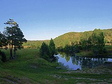

Salair Ridge (pronounced sah-lah-EER; Russian: Салаирский кряж. Salairsky Kryazh ) is an eroded plateau-type highland of low elevation in the Southwestern Siberia, Russia, particularly in Altai Krai, Kemerovo and Novosibirsk Oblast. It is a natural continuation of Altai Mountains and separates the Kuznetsk Depression from the Ob River Plain to the southwest. Its main ridge is nearly parallel to that of Kuznetsk Alatau. The ridge is some 300 kilometres in length and 15-40 kilometres wide.
The mountains are rich in complex ores. The highest peak is Kivda (Russian: Кивда), at 621 meters.[1]
Major rivers include the Berd', Suenga River, and Chumysh River.
See also
- Geography of South-Central Siberia
- South Siberian Mountains
References
- ^ САЛАИ́РСКИЙ КРЯЖ, Great Russian Encyclopedia
External links
- (in Russian)Salair Ridge
- (in Russian)A map of paleolithic settlements at Salair Ridge
54°05′23″N 85°49′40″E / 54.0897°N 85.8278°E / 54.0897; 85.8278
- v
- t
- e
 | This Novosibirsk Oblast location article is a stub. You can help Wikipedia by expanding it. |
- v
- t
- e
 | This Altai Krai location article is a stub. You can help Wikipedia by expanding it. |
- v
- t
- e
Authority control databases | |
|---|---|
| International |
|
| National |
|


