Prague 20
Place in Czech Republic
Prague 20 Praha 20 | |
|---|---|
Municipal District of Prague Administrative District of Prague | |
 Prague 20 town hall | |
 Flag  Coat of arms | |
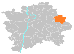 Location of Prague 20 in Prague | |
| Coordinates: 50°6′53″N 14°36′45″E / 50.11472°N 14.61250°E / 50.11472; 14.61250 | |
| Country | Czech Republic |
| Region | Prague |
| Government | |
| • Mayor | Petr Měšťan |
| Area | |
| • Total | 16.95 km2 (6.54 sq mi) |
| Population (2021) | |
| • Total | 15,303 |
| • Density | 900/km2 (2,300/sq mi) |
| Time zone | UTC+1 (CET) |
| • Summer (DST) | UTC+2 (CEST) |
| Postal code | 193 00 |
| Website | http://www.pocernice.cz/ |
Prague 20, also known as Horní Počernice (German Ober Potschernitz), is a municipal district (městská část) in Prague. It is located in the eastern part of the city. It is formed by one cadastre Horní Počernice. As of 2021, there were 15,303 inhabitants living in Prague 20.
The administrative district (správní obvod) of the same name is identical with the municipal district Prague 20.
Demographics
| Year | Pop. | ±% |
|---|---|---|
| 1869 | 1,710 | — |
| 1880 | 1,868 | +9.2% |
| 1890 | 1,938 | +3.7% |
| 1900 | 2,064 | +6.5% |
| 1910 | 2,178 | +5.5% |
| 1921 | 2,748 | +26.2% |
| 1930 | 6,324 | +130.1% |
| 1950 | 7,698 | +21.7% |
| 1961 | 8,358 | +8.6% |
| 1970 | 9,043 | +8.2% |
| 1980 | 10,836 | +19.8% |
| 1991 | 12,162 | +12.2% |
| 2001 | 13,036 | +7.2% |
| 2011 | 15,262 | +17.1% |
| 2021 | 15,303 | +0.3% |
| Source: Censuses[1][2] | ||
Twin towns
 Brunsbüttel, Germany (2004)

References
External links
- Prague 20 - Horní Počernice - Official homepage
- v
- t
- e
Districts and cadastral areas of Prague 

Former names shown in italics
districts
districts
- Běchovice
- Benice
- Březiněves
- Čakovice
- Ďáblice
- Dolní Chabry
- Dolní Měcholupy
- Dolní Počernice
- Dubeč
- Klánovice
- Koloděje
- Kolovraty
- Královice
- Křeslice
- Kunratice
- Libuš
- Lipence
- Lochkov
- Lysolaje
- Nebušice
- Nedvězí
- Petrovice
- Přední Kopanina
- Řeporyje
- Satalice
- Slivenec
- Suchdol
- Šeberov
- Štěrboholy
- Troja
- Újezd u Průhonic
- Velká Chuchle
- Vinoř
- Zbraslav
- Zličín
- Běchovice
- Benice
- Bohnice
- Braník
- Břevnov
- Březiněves
- Bubeneč
- Čakovice
- Černý Most
- Chodov
- Cholupice
- Čimice
- Ďáblice
- Dejvice
- Dolní Chabry
- Dolní Měcholupy
- Dolní Počernice
- Dubeč
- Háje
- Hájek
- Hloubětín
- Hlubočepy
- Hodkovičky
- Holešovice
- Holyně
- Horní Měcholupy
- Horní Počernice
- Hostavice
- Hostivař
- Hradčany
- Hrdlořezy
- Jinonice
- Josefov (Jewish Quarter)
- Kamýk
- Karlín
- Klánovice
- Kobylisy
- Koloděje
- Kolovraty
- Komořany
- Košíře
- Královice
- Krč
- Křeslice
- Kunratice
- Kyje
- Lahovice
- Letňany
- Lhotka
- Libeň
- Liboc
- Libuš
- Lipany
- Lipence
- Lochkov
- Lysolaje
- Malá Chuchle
- Malá Strana ("Lesser Town")
- Malešice
- Michle
- Miškovice
- Modřany
- Motol
- Nebušice
- Nedvězí u Říčan
- Nové Město ("New Town")
- Nusle
- Petrovice
- Písnice
- Pitkovice
- Podolí
- Přední Kopanina
- Prosek
- Radlice
- Radotín
- Řeporyje
- Řepy
- Ruzyně
- Satalice
- Sedlec
- Slivenec
- Smíchov
- Sobín
- Staré Město ("Old Town")
- Štěrboholy
- Stodůlky
- Strašnice
- Střešovice
- Střížkov
- Suchdol
- Točná
- Třebonice
- Třeboradice
- Troja
- Uhříněves
- Újezd nad Lesy
- Újezd (u Průhonic)
- Veleslavín
- Velká Chuchle
- Vinohrady
- Vinoř
- Vokovice
- Vršovice
- Vyšehrad
- Vysočany
- Záběhlice
- Zadní Kopanina
- Zbraslav
- Žižkov
- Zličín
| Authority control databases: National |
|
|---|
 | This Prague location article is a stub. You can help Wikipedia by expanding it. |
- v
- t
- e


