Oliver Johnson's Woods Historic District
Historic district in Indiana, United States
United States historic place
Oliver Johnson's Woods Historic District | |
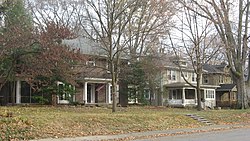 Park Avenue in the neighborhood | |
39°50′23″N 86°8′51″W / 39.83972°N 86.14750°W / 39.83972; -86.14750 | |
| Area | 40 acres (16 ha) |
|---|---|
| Architect | William F. Nelson, Fermor Spencer Cannon, et al. |
| Architectural style | Colonial Revival, Renaissance, et al. |
| NRHP reference No. | 04000632[1] |
| Added to NRHP | June 22, 2004 |
Oliver Johnson's Woods is a historic district and neighborhood on the northern side of Indianapolis, Indiana, United States. Located in southern Washington Township, the district occupies the site of what was once the family farm of Oliver Johnson. Born on the present site of the Indiana State Fairgrounds,[2] Johnson grew up in a pioneer family that lived on the edge of the state capital city.[3] Upon attaining adulthood, he bought property a short distance to the west,[2] to which he moved in 1846. Here, he built a larger farmhouse in 1862,[4] and he tilled the soil for most of the rest of his life. As Indianapolis grew northward, it reached the Johnson farm in the early twentieth century; the aged farmer and his sons saw the city's growth as an opportunity for financial gain, and in 1905 they announced the platting of 0.25 square miles (0.65 km2) of their property into individual lots.[2] They chose an advantageous time to sell their property; as the new residents began to build their homes, an interurban railway was built along College Avenue on the district's western side that connected downtown with Broad Ripple.[4] Many prosperous businessmen were attracted by the development's large lots and wooded streets; the city annexed Oliver Johnson's Woods in 1912, and by the outbreak of World War II, the streets were filled with large houses built in a wide variety of architectural styles.[2] These early residents came from many different ethnicities: European immigrants were becoming more prosperous and leaving their ethnic enclaves, and new neighborhoods such as Oliver Johnson's Woods appealed to them. Among the neighborhood's leading residents was a colony of Jews of German descent.[5]
Houses in the district generally feature architectural styles that were popular in the early twentieth century, such as the Colonial Revival, the Tudor Revival, the Arts and Crafts, the American Foursquare, and the Prairie School. Many of the district's Colonial Revival houses were constructed by William F. Nelson, who acted both as architect and as general contractor for these projects. Standing out from all other houses in the district is the original Johnson farmhouse;[5] now known as the Johnson-Denny House,[1] it originally faced Central Avenue, but its new owner relocated it to face Park Avenue while the surrounding land was being developed in 1919.[5] Other buildings were once located around the house, but they have not survived.[4]
Today, Oliver Johnson's Woods is surrounded by the Meridian-Kessler neighborhood, and it remains the wooded middle-class neighborhood that it was originally planned to be.[2] In 1979, the Johnson-Denny House was listed on the National Register of Historic Places; it was seen as eligible because of its place in local history and because of its well-preserved historic architecture. Twenty-five years later, all of Oliver Johnson's Woods was designated a historic district and added to the Register because of its architecture and local historical importance. The area designated as historic encompasses approximately 40 acres (16 ha); ninety-two different buildings within this zone qualified as contributing properties.[1] Ninety of these buildings are houses; a 1999 historic preservation survey conducted by Indiana Landmarks ranked four of them as "outstanding," seventeen as "notable," and the other sixty-nine simply as "contributing."[4]
References
- ^ a b c "National Register Information System". National Register of Historic Places. National Park Service. March 13, 2009.
- ^ a b c d e Vanderstel, Sheryl D. "Johnson Woods". The Encyclopedia of Indianapolis. Bloomington: Indiana UP, 1994.
- ^ Barrows, Robert G. "Histories of Indianapolis". The Encyclopedia of Indianapolis. Bloomington: Indiana UP, 1994.
- ^ a b c d Indiana Historic Sites and Structures Inventory. Washington Township, Marion County Interim Report. Indianapolis: Indiana Landmarks, 1991, 132-135.
- ^ a b c "Indiana State Historic Architectural and Archaeological Research Database (SHAARD)" (Searchable database). Department of Natural Resources, Division of Historic Preservation and Archaeology. Retrieved August 1, 2016. Note: This includes Sheryl Vanderstel (February 2001). "National Register of Historic Places Inventory Nomination Form: Oliver Johnson's Woods Historic District" (PDF). Retrieved August 1, 2016. and Accompanying photographs
External links
 Media related to Oliver Johnson's Woods Historic District at Wikimedia Commons
- v
- t
- e
- Brendonwood
- Camp Edwin F. Glenn
- Central Court
- Chatham–Arch
- Cottage Home
- Cumberland
- Emerson Avenue Addition
- Fletcher Place
- Forest Hills
- Fort Benjamin Harrison (Boundary Increase)
- Garfield Drive
- Golden Hill
- Haughville
- Herron–Morton Place
- Holy Rosary–Danish Church
- Homecroft
- Indiana Avenue
- Indianapolis Union Station Wholesale District
- Irvington
- Irvington Terrace
- Laurel and Prospect
- Lockerbie Square (Boundary Increase)
- Massachusetts Avenue
- Meridian Park
- New Augusta
- North Meridian Street
- North Pennsylvania Street
- Northside
- North Irvington Gardens
- Old Northside
- Oliver Johnson's Woods
- P.R. Mallory Company Factory
- Ransom Place
- Riverside Drive
- St. Joseph Neighborhood
- St.Philip Neri Parish
- Shortridge–Meridian Street Apartments
- State and Prospect
- Town of Crows Nest
- Virginia Avenue
- Washington Park
- Washington Street–Monument Circle
- Watson Park
- Woodruff Place
- Allison Mansion
- Anderson–Thompson House
- Askren House
- Apple House
- Bals–Wocher House
- Bates–Hendricks House
- Benjamin Harrison Presidential Site
- Benton House
- Byram–Middleton House
- Campbell Mansion
- Cole House & 1925 Cole Brouette No. 70611
- Cotton–Ropkey House
- Flanner House Homes
- Fletcher House
- Glossbrenner Mansion
- Graham House
- Hanna–Ochler–Elder House
- Haverstick Farmstead
- Hill House
- Hollingsworth House
- Horner–Terrill House
- Hubbard House
- Jamieson–Bennett House
- Johnson–Denny House
- Julian–Clark House
- Kuhn House
- Levey Mansion
- Lustron House
- Mattison House
- Meier House
- Millikan House
- Moore House
- Morris–Butler House
- Nicholson–Rand House
- Oldfields
- Pierson–Griffiths House
- The Propylaeum (Schmidt House)
- Prosser House
- Recker House
- Riley House
- Schnull–Rauch House
- Sommer House
- Stewart Mansion
- Stumpf House
- Thompson House
- Tobey-Normington House
- Tomlinson House
- Wheeler–Stokely Mansion
Apartments
and Flats
- Alameda
- Alexandra
- Ambassador
- Baker
- Blacherne
- Burton
- Cathcart
- Chadwick
- Colonial
- Dartmouth
- Delaware Court
- Delaware Flats
- Devonshire
- Emelie
- Glencoe
- Grover
- Harriett
- Lodge
- Martens
- Massachusetts
- Mayleeno
- McKay
- Myrtle Fern
- Oxford
- Pennsylvania
- Plaza
- Rink
- Savoy
- Shelton
- Sid-Mar
- Spink
- Sylvania
- St. Clair
- Vienna
- Wil-Fra-Mar
- Wilson
- Wyndham
Apartments
Libraries
- Administration Building, Indiana Central University
- Arthur Jordan Memorial Hall
- Central Library
- Crispus Attucks High School
- East Washington Library
- Hawthorne Branch Library
- IPS 13
- IPS 33
- IPS 36
- IPS 58
- IPS 66
- IPS 82
- IPS 84
- IPS 97
- Indiana School for the Deaf
- Indiana State Library
- Riverside Branch Library
- Old Southport High School
- Spades Park Library
- Shortridge High School
- Architects and Builders Building
- L.S. Ayres Annex Warehouse
- City Market
- Fame Laundry
- Fidelity Trust Building
- Hammond Block
- Indianapolis News Building
- Jackson Buildings
- Kahn Tailoring Company Building
- Lombard Building
- Majestic Building
- Marott's Shoes Building
- Merchants National Bank and Annex
- Morrison Block
- Reserve Loan Life Insurance Company
- Rink's Womens Apparel Store
- Selig's Dry Goods Company Building
- Taylor Carpet Company Building
- Tee Pee Restaurant
- Test Building
- H. P. Wasson and Company Building
- William Buschmann Block
- Fort Harrison Terminal Station
- Indianapolis Union Station
- Marion County Bridge 0501F
- Michigan Road Toll House
- P.C.C. & St. L. Railroad Freight Depot
- Stout Field Administration Building and Hangar
Theater
- Circle Theater
- Foster Hall
- Indiana Theatre
- Madam C. J. Walker Building
- Rivoli Theater
Recreation
- Broad Ripple Park Carousel
- Bush Stadium
- Highland Golf and Country Club
- Butler Fieldhouse
- Hillcrest Country club
- Indianapolis Motor Speedway
- Woodstock Country Club
- Bethel A.M.E. Church
- Beth-El Zedeck Temple
- Big Run Baptist Church and Cemetery
- Christ Church Cathedral
- Mt. Pisgah Lutheran Church
- Our Savior Lutheran Church
- Roberts Park Methodist Episcopal Church
- St. John's Church and Rectory
- St. Mary's Catholic Church
- St. Timothy’s Episcopal Church
Civic Groups
- Athenaeum
- Christamore House
- Colored Knights of Pythias Castle Hall
- Columbia Club
- General German Protestant Orphans Home
- Independent Turnverein
- Indiana State Federation of Colored Women's Clubs
- Indianapolis Athletic Club
- Indianapolis Masonic Temple
- Maennerchor Building
- Oriental Lodge No. 500
- Scottish Rite Cathedral
- South Side Turnverein Hall
- University Club
Spaces
- Archeological Sites 12Ma648 and 12Ma649
- Caleb Blood Smith Historic Site
- Crown Hill Cemetery
- Crown Hill National Cemetery
- Indiana World War Memorial Plaza
- Indianapolis Park and Boulevard System
- McCormick Cabin Site
- Military Park
- Nurses' Sunken Garden and Convalescent Park
- State Soldiers and Sailors Monument
- University Park
National Register of Historic Places in Indianapolis
Entries in italics have been removed from the registry
Entries in italics have been removed from the registry


