National Register of Historic Places listings in Island County, Washington

This list presents the full set of buildings, structures, objects, sites, or districts designated on the National Register of Historic Places in Island County, Washington, and offers brief descriptive information about each of them. The National Register recognizes places of national, state, or local historic significance across the United States.[1] Out of over 90,000 National Register sites nationwide,[2] Washington is home to approximately 1,500,[3] and 16 of those are found partially or wholly in Island County.
This National Park Service list is complete through NPS recent listings posted June 14, 2024.[4]
Current listings
| [5] | Name on the Register | Image | Date listed[6] | Location | City or town | Description |
|---|---|---|---|---|---|---|
| 1 | Cama Beach Resort | 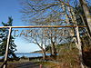 | May 15, 2001 (#01000505) | 1880 SW Camano Dr. 48°08′36″N 122°30′37″W / 48.143333°N 122.510278°W / 48.143333; -122.510278 (Cama Beach Resort) | Camano Island | |
| 2 | Central Whidbey Island Historic District |  | December 12, 1973 (#73001869) | South of Oak Harbor, roughly 6 mi (9.7 km) either side of Coupeville 48°12′43″N 122°41′12″W / 48.211944°N 122.686667°W / 48.211944; -122.686667 (Central Whidbey Island Historic District) | Oak Harbor vicinity | |
| 3 | Deception Pass |  | July 16, 1982 (#82004285) | Rte. 20 48°24′31″N 122°38′37″W / 48.408611°N 122.643611°W / 48.408611; -122.643611 (Deception Pass) | Anacortes | Historic Bridges and Tunnels in Washington TR, also extends into Skagit County |
| 4 | Deception Pass State Park-Cornet Bay Fire Circle | 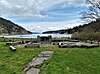 | December 6, 2019 (#100004769) | 41020 WA 20 Coordinates missing | Oak Harbor | |
| 5 | Deception Pass State Park-Cornet Bay Incinerator | Upload image | December 6, 2019 (#100004771) | 41020 WA 20 Coordinates missing | Oak Harbor | |
| 6 | Deception Pass State Park-Cranberry Lake Bathing and Picnic Area Historic District |  | December 4, 2019 (#100004770) | 41020 WA 20 Coordinates missing | Oak Harbor | |
| 7 | Deception Pass State Park-Cranberry Lake Caretaker's Area Historic District | November 22, 2019 (#100004647) | 41020 WA 20 Coordinates missing | Oak Harbor | ||
| 8 | Deception Pass State Park-North Beach Picnic Area Historic District |  | November 22, 2019 (#100004645) | 41020 WA 20 Coordinates missing | Oak Harbor | |
| 9 | Deception Pass State Park-Rosario and Bowman Bathing, Picnic, and Caretaker's Areas Historic District |  | December 4, 2019 (#100004772) | 41020 WA 20 Coordinates missing | Oak Harbor | |
| 10 | Colonel Granville & Henrietta Haller House |  | December 2, 2022 (#100008426) | 1 NE Front St. 48°13′15″N 122°41′09″W / 48.2209°N 122.6859°W / 48.2209; -122.6859 (Colonel Granville & Henrietta Haller House) | Coupeville | |
| 11 | Kristoferson Dairy |  | January 3, 2012 (#11000986) | 393 N. East Camano Dr. 48°13′28″N 122°28′51″W / 48.224417°N 122.480864°W / 48.224417; -122.480864 (Kristoferson Dairy) | Stanwood vicinity | part of the Barns of Washington State MPS |
| 12 | Benjamin Loers House |  | August 29, 1977 (#77001334) | 2046 Swantown Rd. 48°17′03″N 122°40′01″W / 48.284167°N 122.666944°W / 48.284167; -122.666944 (Benjamin Loers House) | Oak Harbor | |
| 13 | Olympic Club |  | May 28, 1991 (#91000630) | 230 1st St. 48°02′28″N 122°24′29″W / 48.041111°N 122.408056°W / 48.041111; -122.408056 (Olympic Club) | Langley | |
| 14 | Site 45-IS-2 | 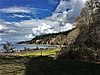 | December 11, 2008 (#08001185) | Address Restricted | Camano Island | Also known as the Cama Beach Archaeological Site. |
| 15 | Smith Island Light Station | 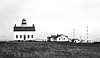 | April 6, 1978 (#78002746) | Northwest of Oak Harbor 48°19′07″N 122°50′37″W / 48.318611°N 122.843611°W / 48.318611; -122.843611 (Smith Island Light Station) | Oak Harbor | Lost due to erosion |
| 16 | Utsalady Ladies Aid Building |  | September 25, 1998 (#98001186) | 79 Utsalady Rd. 48°15′08″N 122°28′37″W / 48.252222°N 122.476944°W / 48.252222; -122.476944 (Utsalady Ladies Aid Building) | Camano Island |
See also
- National Register of Historic Places listings in Washington state
- Listings in neighboring counties: Jefferson, Kitsap, San Juan, Skagit, Snohomish
- Historic preservation
- History of Washington (state)
- Index of Washington (state)-related articles
References
- ^ Andrus, Patrick W.; Shrimpton, Rebecca H.; et al. (2002). "How to Apply the National Register Criteria for Evaluation". National Register Bulletin. National Park Service, U.S. Department of the Interior. Retrieved June 20, 2014.
- ^ National Park Service. "National Register of Historic Places Program: Research". Retrieved January 28, 2015.
- ^ Department of Archaeology and Historic Preservation. "Washington Information System for Architectural and Archaeological Records Data (WISAARD)". Retrieved February 14, 2015.
- ^ National Park Service, United States Department of the Interior, "National Register of Historic Places: Weekly List Actions", retrieved June 14, 2024.
- ^ Numbers represent an alphabetical ordering by significant words. Various colorings, defined here, differentiate National Historic Landmarks and historic districts from other NRHP buildings, structures, sites or objects.
- ^ The eight-digit number below each date is the number assigned to each location in the National Register Information System database, which can be viewed by clicking the number.
External links
Map all coordinates using OpenStreetMap
Download coordinates as:
- KML
- GPX (all coordinates)
- GPX (primary coordinates)
- GPX (secondary coordinates)
- Washington Department of Archaeology and Historic Preservation, Historic Register program
- National Park Service, National Register of Historic Places site
 Media related to National Register of Historic Places in Island County, Washington at Wikimedia Commons
- v
- t
- e
National Register of Historic Places listings in Washington (state)
by county
- Adams
- Asotin
- Benton
- Chelan
- Clallam
- Clark
- Columbia
- Cowlitz
- Douglas
- Ferry
- Franklin
- Garfield
- Grant
- Grays Harbor
- Island
- Jefferson
- King
- Kitsap
- Kittitas
- Lewis
- Lincoln
- Mason
- Okanogan
- Pacific
- Pend Oreille
- Pierce
- San Juan
- Skagit
- Skamania
- Snohomish
- Spokane
- Stevens
- Thurston
- Wahkiakum
- Walla Walla
- Whatcom
- Whitman
- Yakima

- National Historic Landmarks
- Bridges and Tunnels
| |
|---|---|
| Topics | |
| Lists by state |
|
| Lists by insular areas | |
| Lists by associated state | |
| Other areas | |
| Related | |
| |


