National Register of Historic Places listings in Corson County, South Dakota

This is a list of the National Register of Historic Places listings in Corson County, South Dakota.
This is intended to be a complete list of the properties on the National Register of Historic Places in Corson County, South Dakota, United States. The locations of National Register properties for which the latitude and longitude coordinates are included below, may be seen in a map.[1]
There are 8 properties listed on the National Register in the county.
This National Park Service list is complete through NPS recent listings posted June 7, 2024.[2]
Map all coordinates using OpenStreetMap
Download coordinates as:
- KML
- GPX (all coordinates)
- GPX (primary coordinates)
- GPX (secondary coordinates)
Current listings
| [3] | Name on the Register[4] | Image | Date listed[5] | Location | City or town | Description |
|---|---|---|---|---|---|---|
| 1 | Antelope Creek Stage Station |  | June 18, 1992 (#92000692) | Address restricted[6] | Morristown | |
| 2 | Archeological Site No. 39CO39 | | August 6, 1993 (#93000765) | Address restricted[6] | Mahto | |
| 3 | Fort Manuel | Upload image | December 2, 1977 (#77001240) | North of Kenel on the shores of Lake Oahe[7] 45°53′40″N 100°27′32″W / 45.894444°N 100.458889°W / 45.894444; -100.458889 (Fort Manuel) | Kenel | |
| 4 | Grand River Stage Station | | June 18, 1992 (#92000693) | Address restricted[6] | Morristown | |
| 5 | Harding Schoolhouse | Upload image | July 13, 1989 (#89000832) | 5 miles west and 5.5 miles north of Trail City 45°33′10″N 100°50′00″W / 45.552687°N 100.833251°W / 45.552687; -100.833251 (Harding Schoolhouse) | Trail City | Wood frame rural schoolhouse |
| 6 | Holy Spirit Chapel |  | July 7, 1995 (#95000817) | Southeast of the Highway 65 crossing of the Grand River, north of Firesteel 45°37′37″N 101°17′32″W / 45.626944°N 101.292222°W / 45.626944; -101.292222 (Holy Spirit Chapel) | Firesteel | |
| 7 | Sitting Bull Monument | 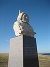 | November 8, 2006 (#06001008) | SE 1/4 of SE 1/4 of Sec 13 T18 R29 45°31′08″N 100°29′07″W / 45.518889°N 100.485278°W / 45.518889; -100.485278 (Sitting Bull Monument) | Mobridge | |
| 8 | South Dakota Dept. of Transportation Bridge No. 16-570-054 | Upload image | December 9, 1993 (#93001279) | Local road over Oak Creek 45°52′13″N 100°49′52″W / 45.870278°N 100.831111°W / 45.870278; -100.831111 (South Dakota Dept. of Transportation Bridge No. 16-570-054) | McLaughlin |
See also
- List of National Historic Landmarks in South Dakota
- National Register of Historic Places listings in South Dakota
References
- ^ The latitude and longitude information provided in this table was derived originally from the National Register Information System, which has been found to be fairly accurate for about 99% of listings. Some locations in this table may have been corrected to current GPS standards.
- ^ National Park Service, United States Department of the Interior, "National Register of Historic Places: Weekly List Actions", retrieved June 7, 2024.
- ^ Numbers represent an alphabetical ordering by significant words. Various colorings, defined here, differentiate National Historic Landmarks and historic districts from other NRHP buildings, structures, sites or objects.
- ^ "National Register Information System". National Register of Historic Places. National Park Service. April 24, 2008.
- ^ The eight-digit number below each date is the number assigned to each location in the National Register Information System database, which can be viewed by clicking the number.
- ^ a b c Federal and state laws and practices restrict general public access to information regarding the specific location of this resource. In some cases, this is to protect archeological sites from vandalism, while in other cases it is restricted at the request of the owner. See: Knoerl, John; Miller, Diane; Shrimpton, Rebecca H. (1990), Guidelines for Restricting Information about Historic and Prehistoric Resources, National Register Bulletin, National Park Service, U.S. Department of the Interior, OCLC 20706997.
- ^ Location derived from its GNIS feature record; the NRIS lists it as "Address Restricted"
- v
- t
- e

county
- Aurora
- Beadle
- Bennett
- Bon Homme
- Brookings
- Brown
- Brule
- Buffalo
- Butte
- Campbell
- Charles Mix
- Clark
- Clay
- Codington
- Corson
- Custer
- Davison
- Day
- Deuel
- Dewey
- Douglas
- Edmunds
- Fall River
- Faulk
- Grant
- Gregory
- Haakon
- Hamlin
- Hand
- Hanson
- Harding
- Hughes
- Hutchinson
- Hyde
- Jackson
- Jerauld
- Jones
- Kingsbury
- Lake
- Lawrence
- Lincoln
- Lyman
- Marshall
- McCook
- McPherson
- Meade
- Mellette
- Miner
- Minnehaha
- Moody
- Oglala Lakota
- Pennington
- Perkins
- Potter
- Roberts
- Sanborn
- Spink
- Stanley
- Sully
- Todd
- Tripp
- Turner
- Union
- Walworth
- Yankton
- Ziebach
 Category
 List
List National Register of Historic Places Portal


Municipalities and communities of Corson County, South Dakota, United States | ||
|---|---|---|
County seat: McIntosh | ||
| Cities |  | |
| Town | ||
| CDPs | ||
| Other communities | ||
| Indian reservation | ||
| Ghost town | ||
| Footnotes | ‡This populated place also has portions in an adjacent county or counties | |
| ||


