Mocanaqua, Pennsylvania
Census-designated place in Pennsylvania, United States
41°8′28″N 76°8′20″W / 41.14111°N 76.13889°W / 41.14111; -76.13889 (2020)[2]
18655[3]
Mocanaqua is an unincorporated community and census-designated place (CDP) in Conyngham Township, Luzerne County, Pennsylvania, United States. The population was 646 at the 2010 census.[6]
Geography
According to the United States Census Bureau, the CDP has a total area of 0.54 square miles (1.4 km2), of which 0.50 square miles (1.3 km2) is land and 0.04 square miles (0.1 km2), or 9.55%, is water.[7] It is located on the east bank of the Susquehanna River along PA 239, which crosses the river and links Mocanaqua to the borough of Shickshinny.
Demographics
| Census | Pop. | Note | %± |
|---|---|---|---|
| 2020 | 515 | — | |
| U.S. Decennial Census[8] | |||
School District
Students attend the Greater Nanticoke Area School District.
Gallery
-
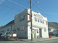 Polish Falcons Hall in Mocanaqua
 -
 Main Street
 -
 Houses in Mocanaqua
 -
 Church in Mocanaqua


References
Wikimedia Commons has media related to Mocanaqua, Pennsylvania.
- ^ "ArcGIS REST Services Directory". United States Census Bureau. Retrieved October 12, 2022.
- ^ "Census Population API". United States Census Bureau. Retrieved October 12, 2022.
- ^ "Mocanaqua PA ZIP Code". zipdatamaps.com. 2023. Retrieved October 31, 2023.
- ^ U.S. Geological Survey Geographic Names Information System: Mocanaqua
- ^ U.S. Geological Survey Geographic Names Information System: Mocanaqua Census Designated Place
- ^ "Profile of General Population and Housing Characteristics: 2010 Demographic Profile Data (DP-1): Mocanaqua CDP, Pennsylvania". United States Census Bureau. Retrieved April 27, 2012.
- ^ "Geographic Identifiers: 2010 Demographic Profile Data (G001): Mocanaqua CDP, Pennsylvania". United States Census Bureau. Retrieved April 27, 2012.
- ^ "Census of Population and Housing". Census.gov. Retrieved June 4, 2016.
- v
- t
- e
Municipalities and communities of Luzerne County, Pennsylvania, United States
County seat: Wilkes-Barre

- Ashley
- Avoca
- Bear Creek Village
- Conyngham
- Courtdale
- Dallas
- Dupont
- Duryea
- Edwardsville
- Exeter
- Forty Fort
- Freeland
- Harveys Lake
- Hughestown
- Jeddo
- Kingston
- Laflin
- Larksville
- Laurel Run
- Luzerne
- Nescopeck
- New Columbus
- Nuangola
- Penn Lake Park
- Plymouth
- Pringle
- Shickshinny
- Sugar Notch
- Swoyersville
- Warrior Run
- West Hazleton
- West Pittston
- West Wyoming
- White Haven
- Wyoming
- Yatesville
- Beech Mountain Lakes
- Browntown
- Chase
- East Berwick
- Georgetown
- Glen Lyon
- Harleigh
- Hickory Hills
- Hilldale
- Hudson
- Inkerman
- Lattimer
- Misericordia University
- Mocanaqua
- Mountain Top
- Nuremberg‡
- Pardeesville
- Pikes Creek
- Plains
- Shavertown
- Sheatown
- Silkworth
- Trucksville
- Upper Exeter
- Wanamie
- West Nanticoke
- Weston
communities
- Alden
- Back Mountain
- Beach Haven
- Breslau
- Cambra
- Cranberry
- Drifton
- Drums
- Ebervale
- Glen Summit Springs
- Harveyville
- Humboldt
- Hunlock Creek
- Huntington Mills
- Japan
- Koonsville
- Korn Krest
- Kunkle
- Lehman
- Milnesville
- Moosehead
- Mossville
- Mountain Grove
- Old Boston
- Port Griffith
- Rock Glen
- Saint Johns
- Sandy Run
- Suscon
- Sweet Valley
- Sybertsville
- Tomhicken
- Wapwallopen
- Waterton
- Zenith
‡This populated place also has portions in an adjacent county or counties
- Pennsylvania portal
- United States portal
Authority control databases | |
|---|---|
| International |
|
| National |
|


