Mónosbél
Municipality in Northern Hungary, Hungary

Coat of arms
(2015)[1]
3345
Mónosbél is a village and municipality (Hungarian: község) in Heves County, Hungary.
References
- ^ http://portal.ksh.hu/pls/portal/cp.hnt_telep?NN=31565 [dead link]
External links
- (in Hungarian) Mónosbél webpage
- v
- t
- e
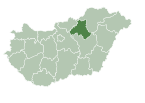
- Bélapátfalva (district seat)

- Balaton
- Bekölce
- Bükkszentmárton
- Mikófalva
- Mónosbél
- Nagyvisnyó
- Szilvásvárad
 | This Heves county location article is a stub. You can help Wikipedia by expanding it. |
- v
- t
- e


