Loring Park, Minneapolis
Neighborhood in Minneapolis, Minnesota, United States
Neighborhood in Hennepin, Minnesota, United States
44°58′12″N 93°17′02″W / 44.97000°N 93.28389°W / 44.97000; -93.28389 (2020)[2]
55403, 55404
| Census | Pop. | Note | %± |
|---|---|---|---|
| 1980 | 5,908 | — | |
| 1990 | 6,586 | 11.5% | |
| 2000 | 7,501 | 13.9% | |
| 2010 | 7,873 | 5.0% | |
| 2020 | 9,718 | 23.4% |
Loring Park is a neighborhood in the Central Community of Minneapolis, Minnesota. Located on the southwest corner of downtown Minneapolis, it also lends its name to Loring Park, the largest park in the neighborhood. The official boundaries of the neighborhood are Lyndale Avenue to the west, Interstate 394 to the north, 12th Street to the northeast, Highway 65 to the east, and Interstate 94 to the south. It is located in Minneapolis City Council Ward 7,[3] represented by Katie Cashman.
Neighborhood characteristics
Loring Park is locally known for its diverse social environment and as a nexus for many arts and cultural events, boasting over 300 businesses and institutions. Loring Park hosts the annual Twin Cities Pride Festival and is the end location of the pride parade. The Loring Park District, according to its official site, offers the "quintessential urban lifestyle," a blend of "condominium and apartment living." The philosophy of the district is one of coalescence: it seeks to mix the old with the new, desiring to become quaint and charming through its combining of the modern with the "historic brownstone."[4]
The Loring Greenway connects Nicollet Mall with Loring Park. The park is surrounded by apartment buildings, many dating from the early 1900s, although recent construction in the area has brought many new town homes and condominiums to the area. In 1972, the Loring Park Development District was created to use tax increment financing to demolish older apartment buildings in an approximately 10-block area and build new higher density buildings and commercial development, such as the Hyatt hotel on Nicollet. The Loring Greenway was created as part of this district.[5] The neighborhood includes part of the Harmon Place Historic District.[6]
Notable buildings
- 430 Oak Grove
- Basilica of St. Mary
- St. Mark's Episcopal Cathedral
- Minneapolis Community and Technical College
- Minneapolis Convention Center
Demographics
In the 2020 Census, 9,718 people lived in the Loring Park neighborhood.[7] According to the 5-year American Community Survey (ACS) data for 2017-2021, 72% of residents were white, 10.9% were Black, 4.7% Asian, 4.6% two or more races, and 5.3% Hispanic or Latino.[8] The neighborhood is majority renters. In the 2017-2021 ACS data, 68.6% of housing units were occupied by renters and 19.6% by owners. The average household size was 1.3 for both owners and renters.[9]
Gallery
-
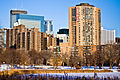 Downtown Minneapolis from Loring Park
 -
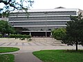 MCTC Technical Building
 -
 Loring Greenway - panoramio
 -
 Loring Park (25650475142)
 -
 Loring Alley, Loring Park, Minneapolis, MN
 -
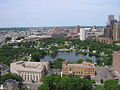 Loring Park Aerial


| Racial composition | 2020[10] |
|---|---|
| White (non-Hispanic) | 72.6% |
| Black or African American (non-Hispanic) | 9.9% |
| Hispanic or Latino | 5.0% |
| Asian (non-Hispanic) | 5.3% |
| Other race (non-Hispanic) | n/a |
| Two or more races (non-Hispanic) | 3.7% |
References
- ^ "Loring Park neighborhood in Minneapolis, Minnesota (MN), 55403, 55404 detailed profile". City-Data. 2011. Retrieved 2013-11-12.
- ^ "Loring Park neighborhood data". Minnesota Compass. Retrieved 2023-02-19.
- ^ "Find My Ward". City of Minneapolis. Retrieved 22 April 2024.
- ^ "Home | Loring Park District - Downtown Minneapolis". Loring Park District. Retrieved 2016-03-08.
- ^ "Loring Park: Loring Greenway and Housing Historical Marker". www.hmdb.org. Retrieved 2023-11-20.
- ^ Minneapolis, City of. "Harmon Place Historic District". www2.minneapolismn.gov. Retrieved 2023-11-20.
- ^ "Loring Park | MN Compass". Minnesota Compass. Retrieved 2023-11-20.
- ^ "Loring Park | MN Compass". Minnesota Compass. Retrieved 2023-11-20.
- ^ "Loring Park | MN Compass". Minnesota Compass. Retrieved 2023-11-20.
- ^ "Loring Park | MN Compass".
External links
Wikimedia Commons has media related to Loring Park, Minneapolis.
- Minneapolis Neighborhood Profile - Loring Park
- Loring Park Neighborhood Plan, 2013
- Citizens for a Loring Park Community
- Loring Business Association
- All of Minneapolis, Loring Park Day 1
- All of Minneapolis, Loring Park Day 2
- v
- t
- e
- Downtown East
- Downtown West
- Elliot Park
- Loring Park
- North Loop
- Stevens Square
- Harrison
- Hawthorne
- Jordan
- Near North
- Sumner-Glenwood
- Willard-Hay
- 38th Street
- Cedar Avenue
- Central Avenue
- Franklin Avenue East
- East Lake Street
- Lowry Avenue North
- West Broadway
For a more comprehensive list, List of neighborhoods in Minneapolis.
Places adjacent to Loring Park, Minneapolis | |
|---|---|


Authority control databases | |
|---|---|
| International |
|
| National |
|


