This is a list of some long-distance footpaths used for walking and hiking.
Africa
Lesotho
3 Ranges Trail: 288.3 km (179.1 mi) a hiking trail that passes three mountain ranges, namely Thaba Putsoa Range, Central Range and ends at Drakensburg Range. It starts at Lesotho lowest point, at the confluence of Makhaleng and Senqu and ends at the country's highest point, Thabana Ntlenyane (3482m).
The Dang: 90 km (56 mi), The route follows the path of the King of the Dangs, from his residence to the Mount Mary Steps via his favourite den at the foot of his Sea Breeze residence.
Valley of the springs Trail (Emek HaMaayanot): 140 km (87 mi) around the Valley of springs near the Sea of Galilee
Haifa Wadis Trail: 50 km (31 mi) trail connecting the Israel National Trail with Haifa and its surroundings
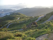
Japan
An aruki-henro or walking pilgrim, marked out by his distinctive sedge hat, white shirt, and kongō-zue
Hokkaidō Nature Trail: 4,585 km (2,849 mi) all over the island of Hokkaidō (in planning)
Tōhoku Nature Trail: 4,374 km (2,718 mi) within Aomori, Iwate, Miyagi, Akita, Yamagata and Fukushima prefectures
Chubu Hokuriku Nature Trail: 4,029 km (2,504 mi) within Gunma, Niigata, Toyama, Ishikawa, Fukui, Nagano, Gifu and Shiga prefectures
Kantō Fureai Trail: 1,665 km (1,035 mi) within Ibaraki, Tochigi, Gunma, Saitama, Chiba, Tōkyō and Kanagawa prefectures. Also known as the Capital Region Nature Trail.[3]
Tōkaidō Nature Trail: 1,697 km (1,054 mi) from Tokyo to Osaka via Kanagawa, Yamanashi, Shizuoka, Aichi, Shiga, Gifu, Mie, Kyōto and Nara prefectures
Kinki Nature Trail: 3,291 km (2,045 mi) within Fukui, Mie, Shiga, Kyōto, Osaka, Hyōgo, Nara, Wakayama and Tottori prefectures
Chugoku Nature Trail: 2,211 km (1,374 mi) within Tottori, Shimane, Okayama, Hiroshima and Yamaguchi prefectures
Shikoku Nature Trail: 1,637 km (1,017 mi) within Ehime, Tokushima, Kagawa and Kōchi prefectures
Kyushu Nature Trail: 2,587 km (1,607 mi) within Fukuoka, Saga, Nagasaki, Kumamoto, Oita, Miyazaki and Kagoshima prefectures
Michinoku Coastal Trail: 1,025 km (637 mi) within Aomori, Iwate, Miyagi and Fukushima prefectures
Japan is also home to several lengthy pilgrimage routes, such as the 1,200 km (750 mi) Shikoku Pilgrimage that visits 88 temples and Mount Kōya. Today these temples and shrines are easily accessible by car and mass transit, but many visitors choose to walk the traditional routes.
Jordan
Jordan Trail: 600 km (370 mi) north-south, cross country from Um Qais to Aqaba[4]
277 km (172 mi) Manaslu Circuit Trek, a 3-week loop trek through the adjacent range to the Annapurna region—the Manaslu region. (see Manaslu Circuit at WikiVoyage)
The Great Himalaya Trail is a proposed 4,500 km (2,800 mi) trail from Namche Barwa, Tibet to Nanga Parbat, Pakistan, with sections in Bhutan, China, and India. It uses existing trails, many of which are trekking, trade, or pilgrimage routes, but no new trails have been built. Starting near Kanchenjunga in the east and ending in Humla in the west, the Nepal section has been walked and documented and is about 1,600 km (990 mi).
Phrygian Way – three separate trekking and cycling trails of total 506 km (314 mi) in the Phrygian Valleys, western Turkey,[2]
Carian Trail – 800 km (500 mi) hugging the south-west coast of Turkey
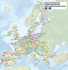
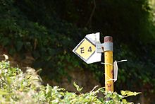
Europe
Some of the best known footpaths in Europe are joined by 12 designated European long-distance paths over some 70,000 km (43,000 mi). Some other popular international routes include:
Tour du Mont Blanc, circling the Mont Blanc massif in Italy, Switzerland, and France. It covers a distance of roughly 170 km (110 mi) with 10 km (6.2 mi) of elevation change.
St James's Way (Camino de Santiago de Compostela),with 2,530 km (1,570 mi) commonly walked through France and Spain, but also including old pilgrimage routes from as far afield as Poland and Portugal
it:Tratturo L'Aquila-Foggia from L'Aquila (Abruzzo region, Italy) to Foggia (Puglia region, Italy). At 244 km (152 mi), Tratturo Magno is the longest and the most important ancient route, traversed by shepherds in Transhumance
The Via Dinarica from Slovenia to Montenegro via the Dinaric Alps connects Croatia, Bosnia and Herzegovina and Montenegro. The trail connects with Kosovo and Albania via the High Scardus Trail.[7]
Sentiero Azzurro is a trail along a rugged portion of coast on the Italian Riviera that connects the five towns known as the Cinque Terre in Liguria, Italy
Primorska planinarska transverzala (Coastal Mountain Transversal), from Herceg Novi to Bar, 180 km (110 mi)
Crnogorska Transverzala (Montenegrin Transversal), from Durmitor to Kučka Krajina, 140 km (87 mi)
Netherlands
Pieterpad trail near Hellendoorn and Laren, Netherlands
Zevenwoudenpad from Lauwersoog to Steenwijk (200 km (120 mi))
Pionierspad from Steenwijk to Muiden (200 km (120 mi))
Floris V-pad from Amsterdam to Bergen op Zoom (245 km (152 mi))
Trekvogelpad from Bergen aan Zee to Enschede (380 km (240 mi))
Marskramerpad from Bad Bentheim to Den Haag (360 km (220 mi))
Maarten van Rossumpad from 's-Hertogenbosch to Ommen (308 km (191 mi))
Deltapad from Sluis to Hook of Holland (237 km (147 mi))
Hollands Kustpad from Hook of Holland to Den Helder (213 km (132 mi))
Friese Kustpad from Stavoren to Lauwersoog (131 km (81 mi))
Wad- en Wierdenpad from Lauwersoog to Nieuweschans (123 km (76 mi))
Oeverloperpad from Rotterdam Europoort to Leerdam (232 km (144 mi))
Lingepad from Leerdam to Nijmegen (German border) (98 km (61 mi))
Pelgrimspad from Amsterdam to Maastricht (453 km (281 mi))
Zuiderzeepad from Enkhuizen to Stavoren (400 km (250 mi))
Pieterpad from Pieterburen to the Sint Pietersberg (492 km (306 mi))
Noaberpad from Nieuweschans to Emmerich (363 km (226 mi))
Grenslandpad from Sluis to Thorn (363 km (226 mi))
Overijssels Havezatenpad from Oldenzaal to Steenwijk (272 km (169 mi))
Peellandpad from 's-Hertogenbosch to Roermond (160 km (99 mi))
Airbornepad from the Belgian border to Arnhem
Norway
Jotunheimen Trail (Norwegian: "Jotunheimstien"): 320 km (200 mi) from downtown Oslo to Lake Gjende in Jotunheimen
Nordkalottruta (Finnish: Kalottireitti, Swedish: Nordkalottleden): 800 km (500 mi) from Kautokeino (located in Finnmark, Northern Norway) to Sulitjelma (Norway) or alternately Kvikkjokk (Sweden)
Atlantic Forest Trail 4,270 km (2,400 mi) follows the Serra do Mar mountain range, crossing five Brazilian States and connecting 10 national parks, and many historical trails and traditional communities. (very hard trail) [17]
Transmantiqueira Trail
1,200 km (750 mi) crosses the Mantiqueira range in a west–east direction (very hard trail)[18]
280 km from Atlantic to Pacific coasts of Costa Rica
• El Camino de Costa Rica [4]
Chile
Central Chile and Patagonia
3,000 km (1,900 mi) Greater Patagonian Trail[20] from the capital Santiago de Chile to the Southern Patagonian Ice Field.
Magallanes
118 km (73 mi). Full circuit of Torres del Paine, including Valle del Francés and access to the base of Torres del Paine.[21]
Dientes de Navarino Circuit ≈53 km (33 mi). 3‑7 days. Starts out of Puerto Williams. Access from mainland Chile by ferry from Punta Areas, plane or from Ushuaia. [22]