List of National Historic Landmarks in Arizona
This is a List of National Historic Landmarks in Arizona. There are 47 National Historic Landmarks (NHLs) in Arizona, counting Hoover Dam that spans from Nevada and is listed in Nevada by the National Park Service (NPS), and Yuma Crossing and Associated Sites, which is listed by the NPS in Arizona, and overlaps into California. The first designated was San Xavier del Bac Mission, in October, 1960. The most recently designated is the Klagetoh (Leegito) Chapter House in January 2021.
Map all coordinates using OpenStreetMap
Download coordinates as:
- KML
- GPX (all coordinates)
- GPX (primary coordinates)
- GPX (secondary coordinates)
Current NHLs
| [1] | Landmark name | Image | Date designated[2] | Location | County | Description |
|---|---|---|---|---|---|---|
| 1 | 1956 Grand Canyon TWA – United Airlines Aviation Accident Site |  | April 23, 2014 (#14000280) | Grand Canyon National Park 36°10′30″N 111°49′59″W / 36.1750°N 111.833°W / 36.1750; -111.833 (1956 Grand Canyon TWA – United Airlines Aviation Accident Site) | Coconino | Crash area of first major (100+ deaths) commercial air disaster in the United States; led to creation of Federal Aviation Administration |
| 2 | Air Force Facility Missile Site 8 (Titan II ICBM Site 571-7) |  | April 19, 1994 (#92001234) | Green Valley 31°54′05″N 110°59′54″W / 31.901339°N 110.998414°W / 31.901339; -110.998414 (Air Force Facility Missile Site 8 ) | Pima | Last surviving Titan II missile launch facility; inactive |
| 3 | Apache Pass and Fort Bowie |  | December 19, 1960 (#72000194) | Bowie 32°08′46″N 109°26′08″W / 32.146111°N 109.435556°W / 32.146111; -109.435556 (Apache Pass and Fort Bowie) | Cochise | Commemorates the conflict between the Chiricahua Apaches and the United States military; preserves the ruins of Fort Bowie |
| 4 | Awatovi Ruins |  | July 19, 1964 (#66000187) | Keams Canyon 35°43′07″N 110°16′37″W / 35.718611°N 110.276944°W / 35.718611; -110.276944 (Awatovi Ruins) | Navajo | Ruins of a 500-year-old pueblo visited by Coronado's men in 1540 |
| 5 | Casa Malpais Site |  | July 19, 1964 (#66000936) | Springerville 34°09′N 109°18′W / 34.15°N 109.3°W / 34.15; -109.3 (Casa Malpais Site) | Apache | Ruin built around 1250; inhabited until about 1400 by Mogollon culture. Tours and museum |
| 6 | Mary Jane Colter buildings |  | May 28, 1987 (#87001436) | South Rim locations in Grand Canyon National Park 36°03′29″N 112°08′13″W / 36.058056°N 112.136944°W / 36.058056; -112.136944 (Mary Jane Colter buildings) | Coconino | Includes Desert View Watchtower, Hermits Rest, Hopi House, and The Lookout. |
| 7 | Desert Laboratory |  | December 21, 1965 (#66000190) | Tucson 32°13′31″N 111°00′09″W / 32.225278°N 111.0025°W / 32.225278; -111.0025 (Desert Laboratory) | Pima | Founded in 1903 to study plant adaptation to an arid desert environment with long term experiments, this laboratory contributed significantly to the formation of Ecology as a science. Part of the University of Arizona |
| 8 | Double Adobe site |  | January 20, 1961 (#66000169) | Douglas 31°21′00″N 109°32′00″W / 31.35°N 109.53333°W / 31.35; -109.53333 (Double Adobe site) | Cochise | Archaeological site where development of the Cochise Culture occurred |
| 9 | El Tovar |  | May 28, 1987 (#74000334) | Grand Canyon Village 36°03′21″N 112°08′13″W / 36.055704°N 112.136999°W / 36.055704; -112.136999 (El Tovar) | Coconino | Classic lodge at South Rim of Grand Canyon |
| 10 | Fort Apache and Theodore Roosevelt School |  | March 2, 2012 (#76000377) | Fort Apache 33°47′23″N 109°59′21″W / 33.789812°N 109.98903°W / 33.789812; -109.98903 (Fort Apache and Theodore Roosevelt School) | Navajo | Site of historic Fort Apache; later converted to a school for the purpose of assimilating the native population. It is now a tribal museum. |
| 11 | Fort Huachuca | 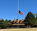 | May 11, 1976 (#74000443) | Sierra Vista 31°33′19″N 110°20′59″W / 31.555278°N 110.349722°W / 31.555278; -110.349722 (Fort Huachuca) | Cochise | Commemorates "Buffalo Soldiers" |
| 12 | Gatlin Site | 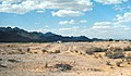 | July 19, 1964 (#66000183) | Gila Bend 32°58′51″N 112°42′06″W / 32.980935°N 112.701612°W / 32.980935; -112.701612 (Gatlin Site) | Maricopa | Preserves a Hohokam platform mound, pit houses, ball courts, middens, and prehistoric canals |
| 13 | Grand Canyon Depot |  | May 28, 1987 (#74000337) | Grand Canyon Village 36°03′15″N 112°08′11″W / 36.054295°N 112.136346°W / 36.054295; -112.136346 (Grand Canyon Depot) | Coconino | Railway station constructed in 1909–10 for the Atchison, Topeka and Santa Fe Railroad |
| 14 | Grand Canyon Lodge |  | May 28, 1987 (#82001721) | North Rim, Grand Canyon National Park 36°11′57″N 112°03′07″W / 36.199167°N 112.051944°W / 36.199167; -112.051944 (Grand Canyon Lodge) | Coconino | Lodge at Bright Angel Point, on North Rim of Grand Canyon |
| 15 | Grand Canyon Park Operations Building | 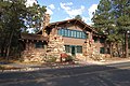 | May 28, 1987 (#87001412) | Grand Canyon Village 36°03′12″N 112°08′13″W / 36.053226°N 112.136908°W / 36.053226; -112.136908 (Grand Canyon Park Operations Building) | Coconino | National Park Service building; built in 1929; designed to blend with the natural surroundings |
| 16 | Grand Canyon Power House | 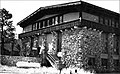 | May 28, 1987 (#87001411) | Grand Canyon Village 36°03′14″N 112°08′24″W / 36.053873°N 112.139970°W / 36.053873; -112.139970 (Grand Canyon Power House) | Coconino | Rustic building designed to conceal the purpose of the building, which was to provide power to the railroad. |
| 17 | Grand Canyon Village |  | February 18, 1987 (#75000343) | Grand Canyon Village 36°03′20″N 112°08′18″W / 36.055556°N 112.138333°W / 36.055556; -112.138333 (Grand Canyon Village) | Coconino | Planned town significant for its urban planning and ecological sensitivity |
| 18 | Hoover Dam |  | August 20, 1985 (#81000382) | Lake Mead National Recreation Area 36°00′56″N 114°44′16″W / 36.015556°N 114.737778°W / 36.015556; -114.737778 (Hoover Dam) | Mohave, AZ and Clark, NV | Historic dam, power plant and water-storage facility |
| 19 | Hubbell Trading Post |  | December 12, 1960 (#66000167) | Ganado 35°43′32″N 109°35′36″W / 35.725556°N 109.59333°W / 35.725556; -109.59333 (Hubbell Trading Post) | Apache | Meeting ground of two cultures, the Navajo and the settlers |
| 20 | Jerome Historic District |  | November 13, 1966 (#66000196) | Jerome 34°45′13″N 112°06′41″W / 34.753611°N 112.111389°W / 34.753611; -112.111389 (Jerome Historic District) | Yavapai | Copper mining town |
| 21 | Kinishba Ruins |  | July 19, 1964 (#66000180) | Whiteriver 33°48′53″N 110°03′16″W / 33.814722°N 110.054444°W / 33.814722; -110.054444 (Kinishba Ruins) | Gila | Large pueblo ruin; accessible via Fort Apache Historical Park. |
| 22 | Klagetoh (Leegito) Chapter House | Upload image | January 13, 2021 (#100006279) | Klagetoh 35°29′58″N 109°31′48″W / 35.4994°N 109.5299°W / 35.4994; -109.5299 (Klagetoh (Leegito) Chapter House) | Apache | |
| 23 | Lehner Mammoth-Kill Site |  | May 28, 1967 (#67000002) | Hereford 31°26′00″N 110°06′00″W / 31.433333°N 110.1°W / 31.433333; -110.1 (Lehner Mammoth-Kill Site) | Cochise | Clovis culture mammoth butchering site |
| 24 | Los Santos Ángeles de Guevavi |  | June 21, 1990 (#71000119) | Nogales 31°24′36″N 110°54′10″W / 31.409908°N 110.902689°W / 31.409908; -110.902689 (Los Santos Ángeles de Guevavi) | Santa Cruz | Ruins of Spanish mission church; founded 1691 |
| 25 | Lowell Observatory |  | December 21, 1965 (#66000172) | Flagstaff 35°12′10″N 111°39′52″W / 35.202778°N 111.664444°W / 35.202778; -111.664444 (Lowell Observatory) | Coconino | Observatory where Pluto was discovered |
| 26 | C. Hart Merriam Base Camp Site |  | December 21, 1965 (#66000173) | Flagstaff 35°22′29″N 111°43′34″W / 35.374824°N 111.725990°W / 35.374824; -111.725990 (C. Hart Merriam Base Camp Site) | Coconino | Work site of C. Hart Merriam, path-breaking eco-biologist |
| 27 | Murray Springs Clovis Site | 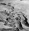 | October 16, 2012 (#12001019) | Sierra Vista 31°34′14″N 110°08′27″W / 31.570638°N 110.140872°W / 31.570638; -110.140872 (Murray Springs Clovis Site) | Cochise | Clovis culture site associated with bison and mammoth kills; site open to public. |
| 28 | Navajo Nation Council Chamber |  | August 18, 2004 (#04001155) | Window Rock 35°40′58″N 109°02′54″W / 35.682778°N 109.048333°W / 35.682778; -109.048333 (Navajo Nation Council Chamber) | Apache | Center of government for Navajo Nation. |
| 29 | Old Oraibi |  | July 19, 1964 (#66000188) | Oraibi 35°52′35″N 110°38′25″W / 35.876389°N 110.640278°W / 35.876389; -110.640278 (Old Oraibi) | Navajo | Historic Hopi village |
| 30 | Painted Desert Community Complex Historic District |  | December 23, 2016 (#100000838) | One Park Rd. 35°04′06″N 109°46′50″W / 35.068333°N 109.780556°W / 35.068333; -109.780556 (Painted Desert Community Complex Historic District) | Apache | |
| 31 | Painted Desert Inn | 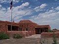 | May 28, 1987 (#87001421) | Petrified Forest National Park 35°05′01″N 109°47′20″W / 35.083737°N 109.788845°W / 35.083737; -109.788845 (Painted Desert Inn) | Apache | Lodge in the Petrified Forest National Park |
| 32 | Phelps Dodge General Office Building |  | May 4, 1983 (#71000109) | Bisbee 31°26′25″N 109°54′41″W / 31.440186°N 109.911261°W / 31.440186; -109.911261 (Phelps Dodge General Office Building) | Cochise | Phelps Dodge mining company headquarters from 1896 to 1961 |
| 33 | Point of Pines Sites |  | July 19, 1964 (#66000182) | San Carlos Apache Indian Reservation 33°21′13″N 109°44′40″W / 33.3535°N 109.7445°W / 33.3535; -109.7445 (Point of Pines Sites) | Graham | Set of archaeological sites associated with Anasazi, Mogollon and Hohokam cultures; location is site of archaeological field camp |
| 34 | Poston Elementary School, Unit 1, Colorado River Relocation Center |  | October 16, 2012 (#12001010) | Parker 33°59′31″N 114°24′24″W / 33.991943°N 114.406625°W / 33.991943; -114.406625 (Poston Elementary School, Unit 1, Colorado River Relocation Center) | La Paz | Located at the former Poston War Relocation Center, this is the only surviving elementary school building from any World War II-era Japanese internment camp. |
| 35 | Pueblo Grande Ruin and Irrigation Sites |  | July 19, 1964 (#66000185) | Phoenix 33°26′47″N 111°59′03″W / 33.446389°N 111.984167°W / 33.446389; -111.984167 (Pueblo Grande Ruin and Irrigation Sites) | Maricopa | Pueblo Grande Ruin and adjacent Hohokam-Pima Irrigation Sites |
| 36 | Sage Memorial Hospital School of Nursing | Upload image | January 16, 2009 (#09000082) | Ganado 35°42′40″N 109°32′36″W / 35.711073°N 109.543446°W / 35.711073; -109.543446 (Sage Memorial Hospital School of Nursing) | Apache | |
| 37 | San Bernardino Ranch |  | July 19, 1964 (#66000170) | Douglas 31°20′11″N 109°16′47″W / 31.336389°N 109.279722°W / 31.336389; -109.279722 (San Bernardino Ranch) | Cochise | Historic cattle ranch |
| 38 | San Cayetano de Calabazas |  | December 14, 1990 (#71000118) | Nogales 31°27′09″N 110°57′34″W / 31.4525°N 110.959444°W / 31.4525; -110.959444 (San Cayetano de Calabazas) | Santa Cruz | Spanish mission, also known as Calabasas; part of Tumacácori National Historic Park. |
| 39 | San Xavier del Bac Mission |  | October 9, 1960 (#66000191) | Tucson 32°06′25″N 111°00′29″W / 32.107°N 111.008°W / 32.107; -111.008 (San Xavier del Bac Mission) | Pima | Spanish mission founded in 1699 |
| 40 | Sierra Bonita Ranch |  | July 19, 1964 (#66000181) | Bonita 32°35′00″N 109°58′00″W / 32.583333°N 109.966667°W / 32.583333; -109.966667 (Sierra Bonita Ranch) | Cochise and Graham | First permanent American cattle ranch in Arizona |
| 41 | Snaketown |  | April 29, 1964 (#07001462) | Hohokam Pima National Monument 33°10′59″N 111°55′12″W / 33.183056°N 111.92°W / 33.183056; -111.92 (Snaketown) | Pinal | Archaeological remains of the Hohokam culture |
| 42 | Taliesin West | 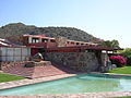 | May 20, 1982 (#74000457) | Scottsdale 33°36′11″N 111°50′38″W / 33.603111°N 111.843781°W / 33.603111; -111.843781 (Taliesin West) | Maricopa | Winter home of architect Frank Lloyd Wright |
| 43 | Tombstone Historic District |  | July 4, 1961 (#66000171) | Tombstone 31°42′45″N 110°03′59″W / 31.7125°N 110.066389°W / 31.7125; -110.066389 (Tombstone Historic District) | Cochise | Classic Western mining boomtown; location of the OK Corral |
| 44 | Tumacacori Museum |  | May 28, 1987 (#87001437) | Tumacacori 31°33′58″N 111°03′01″W / 31.566065°N 111.050402°W / 31.566065; -111.050402 (Tumacacori Museum) | Santa Cruz | Museum to Spanish missions that itself is an architectural landmark |
| 45 | Ventana Cave |  | January 20, 1964 (#66000189) | Santa Rosa 32°21′00″N 112°14′00″W / 32.35°N 112.233333°W / 32.35; -112.233333 (Ventana Cave) | Pima | Archaeological site; has evidence of Native American occupation of the area for the last 4,000 years |
| 46 | Winona Site | Upload image | July 19, 1964 (#66000177) | Winona 35°12′00″N 111°24′00″W / 35.200°N 111.400°W / 35.200; -111.400 (Winona Site) | Coconino | Archaeological site; evidence of cultural change following eruption of Sunset Crater |
| 47 | Yuma Crossing and Associated Sites |  | November 13, 1966 (#66000197) | Yuma, AZ and Winterhaven, CA 32°43′43″N 114°36′52″W / 32.728611°N 114.614444°W / 32.728611; -114.614444 (Yuma Crossing and Associated Sites) | Yuma County, AZ and Imperial County, CA | Archaeological and historical sites including Yuma Quartermaster Depot and Arizona Territorial Prison |
Former listing
| Landmark name | Image | Date of designation[3] | Date of move or dedesignation | Location | County | Description | |
|---|---|---|---|---|---|---|---|
| 1 | Roosevelt Dam | 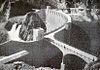 | May 23, 1963[4] | March 10, 1999[4] | Roosevelt | Gila and Maricopa | When built in 1906–11, this was the highest masonry dam in the world, and the first major reclamation project dam in the western United States. It was substantially altered in 1989–96, enlarging the structure and encasing the original in concrete.[4] |
See also
Map all coordinates using OpenStreetMap
Download coordinates as:
- KML
- GPX (all coordinates)
- GPX (primary coordinates)
- GPX (secondary coordinates)
 Arizona portal

- National Register of Historic Places listings in Arizona
- List of National Historic Landmarks by state
- List of historic properties in Phoenix, Arizona
- List of historic properties in Glendale, Arizona
Notes
- ^ Numbers represent an alphabetical ordering by significant words. Various colorings, defined here, differentiate National Historic Landmarks and historic districts from other NRHP buildings, structures, sites or objects.
- ^ The eight-digit number below each date is the number assigned to each location in the National Register Information System database, which can be viewed by clicking the number.
- ^ National Park Service (June 2010). "National Historic Landmarks Survey: List of National Historic Landmarks by State" (PDF). U.S. Department of the Interior. Retrieved October 4, 2010.
{{cite journal}}: Cite journal requires|journal=(help) - ^ a b c "Withdrawal of Designation: Roosevelt Dam". National Park Service. Retrieved April 13, 2015.
External links
- "National Historic Landmarks Survey: List of National Historic Landmarks by State – Arizona (40)" (PDF). National Park Service. Retrieved November 7, 2007.
- National Historic Landmarks Program, at National Park Service
- v
- t
- e

| National Parks | |
|---|---|
| National Historical Parks, Historic Sites and Memorials | |
| National Monuments | |
| National Conservation Areas | |
| National Recreation Areas | |
| National Trails |
|
| National Forests | |
| National Wildlife Refuges | |
| Wilderness Areas | |
| Wild and Scenic Rivers |
| Nature parks |
|---|
| National Natural Landmarks | |
|---|---|
| National Historic Landmarks | See List of National Historic Landmarks in Arizona |
| Historic Places |
- Arizona State Parks
| |
|---|---|
| Topics | |
| Lists by state |
|
| Lists by insular areas | |
| Lists by associated state | |
| Other areas | |
| Related | |
| |


