Lewiston–Clarkston metropolitan area
Metropolitan Statistical Area in the United States
Lewiston–Clarkston metropolitan area | ||
|---|---|---|
Metropolitan Statistical Area | ||
| Lewiston, ID–WA Metropolitan Statistical Area | ||
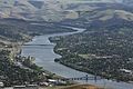
 Lewiston from the north (2006) | ||
 Map of Lewiston, ID–WA MSA
| ||
| Coordinates: 46°N 117°W / 46°N 117°W / 46; -117 | ||
| Country |  United States United States | |
| State |  Idaho Idaho Washington Washington | |
| Largest city | Lewiston, ID (32,873) | |
| Other cities | Clarkston, WA (7,341) | |
| Area | ||
| • Total | 1,497 sq mi (3,880 km2) | |
| Population | ||
| • Total | 62,675 | |
| • Rank | 380th in the U.S. | |
| • Density | 41.9/sq mi (16.6/km2) | |
| Time zone | UTC-8 (PST) | |
| • Summer (DST) | UTC-7 (PDT) | |
The Lewiston–Clarkston metropolitan area—colloquially referred to as the Lewiston–Clarkston Valley or Lewis–Clark Valley (often abbreviated as LC Valley), and officially known as the Lewiston, ID–WA Metropolitan Statistical Area—is a metropolitan area comprising Nez Perce County, Idaho, and Asotin County, Washington. The metro is anchored by the cities of Lewiston, Idaho, and Clarkston, Washington—named after Meriwether Lewis and William Clark,[A] respectively. As of the 2010 census, the MSA had a population of 60,888 (though a July 1, 2011 estimate placed the population at 61,476),[1] making it the 4th smallest metropolitan area in the United States.
Geography
Counties
Communities
- Anatone, Washington (unincorporated)
- Asotin, Washington
- Clarkston Heights-Vineland, Washington (unincorporated)
- Clarkston, Washington
- Culdesac, Idaho
- Lapwai, Idaho
- Lewiston, Idaho (Principal city)
- Peck, Idaho
- Spalding, Idaho (unincorporated)
- West Clarkston-Highland, Washington (unincorporated)
Features
- Lewiston Hill
- Lower Granite Lake
- Snake River
- Clearwater River (Idaho)
- Bridges
- Interstate Highway Bridge
- Southway Bridge
- Clearwater Memorial Bridge
- Red Wolf Crossing
- Highways
Photos


Demographics
As of the census of 2000, there were 57,961 people, 23,650 households, and 15,803 families residing within the MSA. The racial makeup of the MSA was 93.01% White, 0.25% African American, 3.88% Native American, 0.60% Asian, 0.06% Pacific Islander, 0.55% from other races, and 1.66% from two or more races. Hispanic or Latino of any race were 1.94% of the population.
The median income for a household in the MSA was $34,903, and the median income for a family was $42,402. Males had a median income of $35,249 versus $24,616 for females. The per capita income for the MSA was $18,146.
See also
Notes
- ^ of the Lewis and Clark Expedition
References
- ^ "Table 1. Annual Estimates of the Population of Metropolitan and Micropolitan Statistical Areas: April 1, 2010 to July 1, 2011 (CBSA-EST2011-01)". 2011 Population Estimates. United States Census Bureau, Population Division. 2012-09-14. Archived from the original (CSV) on April 27, 2012. Retrieved 2012-09-14.
- ^ Thain Road up to the "Lewiston Orchards" is often referred to as "Thain Grade": https://www.openstreetmap.org/way/256628692
- v
- t
- e
State of Idaho
Boise (capital)
- Index
- Geography
- Government
- Delegations
- Governors
- History
- Images
- People
- Symbols
- Tourist attractions
cities
cities
- Ada
- Adams
- Bannock
- Bear Lake
- Benewah
- Bingham
- Blaine
- Boise
- Bonner
- Bonneville
- Boundary
- Butte
- Camas
- Canyon
- Caribou
- Cassia
- Clark
- Clearwater
- Custer
- Elmore
- Franklin
- Fremont
- Gem
- Gooding
- Idaho
- Jefferson
- Jerome
- Kootenai
- Latah
- Lemhi
- Lewis
- Lincoln
- Madison
- Minidoka
- Nez Perce
- Oneida
- Owyhee
- Payette
- Power
- Shoshone
- Teton
- Twin Falls
- Valley
- Washington
 Idaho portal

46°25′N 117°01′W / 46.41°N 117.02°W / 46.41; -117.02


