Leutenheim
You can help expand this article with text translated from the corresponding article in French. (December 2008) Click [show] for important translation instructions.
- View a machine-translated version of the French article.
- Machine translation, like DeepL or Google Translate, is a useful starting point for translations, but translators must revise errors as necessary and confirm that the translation is accurate, rather than simply copy-pasting machine-translated text into the English Wikipedia.
- Do not translate text that appears unreliable or low-quality. If possible, verify the text with references provided in the foreign-language article.
- You must provide copyright attribution in the edit summary accompanying your translation by providing an interlanguage link to the source of your translation. A model attribution edit summary is
Content in this edit is translated from the existing French Wikipedia article at [[:fr:Leutenheim]]; see its history for attribution. - You may also add the template
{{Translated|fr|Leutenheim}}to the talk page. - For more guidance, see Wikipedia:Translation.
Commune in Grand Est, France
Leutenheim Littenem | ||
|---|---|---|
Commune | ||
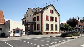 The town hall in Leutenheim | ||
 Coat of arms | ||
Location of Leutenheim  | ||
(2020–2026) Marc Antoni[1] | | |
| Area 1 | 10.39 km2 (4.01 sq mi) | |
| Population (2021)[2] | 830 | |
| • Density | 80/km2 (210/sq mi) | |
| Time zone | UTC+01:00 (CET) | |
| • Summer (DST) | UTC+02:00 (CEST) | |
| INSEE/Postal code | 67264 /67480 | |
| Elevation | 115–139 m (377–456 ft) | |
| 1 French Land Register data, which excludes lakes, ponds, glaciers > 1 km2 (0.386 sq mi or 247 acres) and river estuaries. | ||
Leutenheim is a commune in the Bas-Rhin department in Grand Est in north-eastern France.[3] It lies 20 kilometres (12 mi) east of Haguenau and a short distance west of the Rhine, which here defines the frontier between France and Germany.
History
In eighth- and ninth-century records the village appears as Lithaim.
In around 1140 Königsbrück Abbey was founded here, a Cistercian nunnery, dissolved during the French Revolution.
Before the Rhine was channeled, the landscape here was marshy and criss-crossed by branches of the river. Accordingly, the settlement is constructed on warfts.
See also
References
- ^ "Répertoire national des élus: les maires". data.gouv.fr, Plateforme ouverte des données publiques françaises (in French). 9 August 2021.
- ^ "Populations légales 2021". The National Institute of Statistics and Economic Studies. 28 December 2023.
- ^ INSEE commune file
Wikimedia Commons has media related to Leutenheim.
- v
- t
- e

- Achenheim
- Adamswiller
- Albé
- Alteckendorf
- Altenheim
- Altorf
- Altwiller
- Andlau
- Artolsheim
- Aschbach
- Asswiller
- Avolsheim
- Baerendorf
- Balbronn
- Baldenheim
- Barembach
- Barr
- Bassemberg
- Batzendorf
- Beinheim
- Bellefosse
- Belmont
- Benfeld
- Berg
- Bergbieten
- Bernardswiller
- Bernardvillé
- Bernolsheim
- Berstett
- Berstheim
- Betschdorf
- Bettwiller
- Biblisheim
- Bietlenheim
- Bilwisheim
- Bindernheim
- Bischheim
- Bischholtz
- Bischoffsheim
- Bischwiller
- Bissert
- Bitschhoffen
- Blaesheim
- Blancherupt
- Blienschwiller
- Bœrsch
- Bœsenbiesen
- Bolsenheim
- Boofzheim
- Bootzheim
- Bosselshausen
- Bossendorf
- Bourg-Bruche
- Bourgheim
- Bouxwiller
- Breitenau
- Breitenbach
- Breuschwickersheim
- La Broque
- Brumath
- Buhl
- Burbach
- Bust
- Buswiller
- Butten
- Châtenois
- Cleebourg
- Climbach
- Colroy-la-Roche
- Cosswiller
- Crastatt
- Crœttwiller
- Dachstein
- Dahlenheim
- Dalhunden
- Dambach
- Dambach-la-Ville
- Dangolsheim
- Daubensand
- Dauendorf
- Dehlingen
- Dettwiller
- Diebolsheim
- Diedendorf
- Dieffenbach-au-Val
- Dieffenbach-lès-Wœrth
- Dieffenthal
- Diemeringen
- Dimbsthal
- Dingsheim
- Dinsheim-sur-Bruche
- Domfessel
- Donnenheim
- Dorlisheim
- Dossenheim-Kochersberg
- Dossenheim-sur-Zinsel
- Drachenbronn-Birlenbach
- Drulingen
- Drusenheim
- Duntzenheim
- Duppigheim
- Durningen
- Durrenbach
- Durstel
- Duttlenheim
- Eberbach-Seltz
- Ebersheim
- Ebersmunster
- Eckartswiller
- Eckbolsheim
- Eckwersheim
- Eichhoffen
- Elsenheim
- Engwiller
- Entzheim
- Epfig
- Erckartswiller
- Ergersheim
- Ernolsheim-Bruche
- Ernolsheim-lès-Saverne
- Erstein
- Eschau
- Eschbach
- Eschbourg
- Eschwiller
- Ettendorf
- Eywiller
- Fegersheim
- Fessenheim-le-Bas
- Flexbourg
- Forstfeld
- Forstheim
- Fort-Louis
- Fouchy
- Fouday
- Friedolsheim
- Friesenheim
- Frœschwiller
- Frohmuhl
- Furchhausen
- Furdenheim
- Gambsheim
- Geispolsheim
- Geiswiller-Zœbersdorf
- Gerstheim
- Gertwiller
- Geudertheim
- Gœrlingen
- Gœrsdorf
- Gottenhouse
- Gottesheim
- Gougenheim
- Goxwiller
- Grandfontaine
- Grassendorf
- Grendelbruch
- Gresswiller
- Gries
- Griesheim-près-Molsheim
- Griesheim-sur-Souffel
- Gumbrechtshoffen
- Gundershoffen
- Gungwiller
- Gunstett
- Haegen
- Haguenausubpr
- Handschuheim
- Hangenbieten
- Harskirchen
- Hatten
- Hattmatt
- Hegeney
- Heidolsheim
- Heiligenberg
- Heiligenstein
- Hengwiller
- Herbitzheim
- Herbsheim
- Herrlisheim
- Hessenheim
- Hilsenheim
- Hindisheim
- Hinsbourg
- Hinsingen
- Hipsheim
- Hirschland
- Hochfelden
- Hochstett
- Hœnheim
- Hœrdt
- Hoffen
- Hohengœft
- Hohfrankenheim
- Le Hohwald
- Holtzheim
- Hunspach
- Hurtigheim
- Huttendorf
- Huttenheim
- Ichtratzheim
- Illkirch-Graffenstaden
- Ingenheim
- Ingolsheim
- Ingwiller
- Innenheim
- Issenhausen
- Ittenheim
- Itterswiller
- Jetterswiller
- Kaltenhouse
- Kauffenheim
- Keffenach
- Kertzfeld
- Keskastel
- Kesseldorf
- Kienheim
- Kilstett
- Kindwiller
- Kintzheim
- Kirchheim
- Kirrberg
- Kirrwiller
- Kleingœft
- Knœrsheim
- Kogenheim
- Kolbsheim
- Krautergersheim
- Krautwiller
- Kriegsheim
- Kurtzenhouse
- Kuttolsheim
- Kutzenhausen
- Lalaye
- Lampertheim
- Lampertsloch
- Landersheim
- Langensoultzbach
- Laubach
- Lauterbourg
- Lembach
- Leutenheim
- Lichtenberg
- Limersheim
- Lingolsheim
- Lipsheim
- Littenheim
- Lixhausen
- Lobsann
- Lochwiller
- Lohr
- Lorentzen
- Lupstein
- Lutzelhouse
- Mackenheim
- Mackwiller
- Maennolsheim
- Maisonsgoutte
- Marckolsheim
- Marlenheim
- Marmoutier
- Matzenheim
- Meistratzheim
- Melsheim
- Memmelshoffen
- Menchhoffen
- Merkwiller-Pechelbronn
- Mertzwiller
- Mietesheim
- Minversheim
- Mittelbergheim
- Mittelhausbergen
- Mittelschaeffolsheim
- Mollkirch
- Molsheimsubpr
- Mommenheim
- Monswiller
- Morsbronn-les-Bains
- Morschwiller
- Mothern
- Muhlbach-sur-Bruche
- Mulhausen
- Munchhausen
- Mundolsheim
- Mussig
- Muttersholtz
- Mutzenhouse
- Mutzig
- Natzwiller
- Neewiller-près-Lauterbourg
- Neubois
- Neugartheim-Ittlenheim
- Neuhaeusel
- Neuve-Église
- Neuviller-la-Roche
- Neuwiller-lès-Saverne
- Niederbronn-les-Bains
- Niederhaslach
- Niederhausbergen
- Niederlauterbach
- Niedermodern
- Niedernai
- Niederrœdern
- Niederschaeffolsheim
- Niedersoultzbach
- Niedersteinbach
- Nordheim
- Nordhouse
- Nothalten
- Obenheim
- Oberbronn
- Oberdorf-Spachbach
- Oberhaslach
- Oberhausbergen
- Oberhoffen-lès-Wissembourg
- Oberhoffen-sur-Moder
- Oberlauterbach
- Obermodern-Zutzendorf
- Obernai
- Oberrœdern
- Oberschaeffolsheim
- Obersoultzbach
- Obersteinbach
- Odratzheim
- Oermingen
- Offendorf
- Offwiller
- Ohlungen
- Ohnenheim
- Olwisheim
- Orschwiller
- Osthoffen
- Osthouse
- Ostwald
- Ottersthal
- Otterswiller
- Ottrott
- Ottwiller
- Petersbach
- La Petite-Pierre
- Pfalzweyer
- Pfulgriesheim
- Plaine
- Plobsheim
- Preuschdorf
- Printzheim
- Puberg
- Quatzenheim
- Rangen
- Ranrupt
- Ratzwiller
- Rauwiller
- Reichsfeld
- Reichshoffen
- Reichstett
- Reinhardsmunster
- Reipertswiller
- Retschwiller
- Reutenbourg
- Rexingen
- Rhinau
- Richtolsheim
- Riedseltz
- Rimsdorf
- Ringendorf
- Rittershoffen
- Rœschwoog
- Rohr
- Rohrwiller
- Romanswiller
- Roppenheim
- Rosenwiller
- Rosheim
- Rossfeld
- Rosteig
- Rothau
- Rothbach
- Rott
- Rottelsheim
- Rountzenheim-Auenheim
- Russ
- Saales
- Saasenheim
- Saessolsheim
- Saint-Blaise-la-Roche
- Saint-Jean-Saverne
- Saint-Martin
- Saint-Maurice
- Saint-Nabor
- Saint-Pierre
- Saint-Pierre-Bois
- Salmbach
- Sand
- Sarre-Union
- Sarrewerden
- Saulxures
- Savernesubpr
- Schaeffersheim
- Schaffhouse-près-Seltz
- Schalkendorf
- Scharrachbergheim-Irmstett
- Scheibenhard
- Scherlenheim
- Scherwiller
- Schillersdorf
- Schiltigheim
- Schirmeck
- Schirrhein
- Schirrhoffen
- Schleithal
- Schnersheim
- Schœnau
- Schœnbourg
- Schœnenbourg
- Schopperten
- Schweighouse-sur-Moder
- Schwenheim
- Schwindratzheim
- Schwobsheim
- Seebach
- Sélestatsubpr
- Seltz
- Sermersheim
- Sessenheim
- Siegen
- Siewiller
- Siltzheim
- Solbach
- Sommerau
- Souffelweyersheim
- Soufflenheim
- Soultz-les-Bains
- Soultz-sous-Forêts
- Sparsbach
- Stattmatten
- Steige
- Steinbourg
- Steinseltz
- Still
- Stotzheim
- Strasbourgpref
- Struth
- Stundwiller
- Stutzheim-Offenheim
- Sundhouse
- Surbourg
- Thal-Drulingen
- Thal-Marmoutier
- Thanvillé
- Tieffenbach
- Traenheim
- Triembach-au-Val
- Trimbach
- Truchtersheim
- Uhlwiller
- Uhrwiller
- Urbeis
- Urmatt
- Uttenheim
- Uttenhoffen
- Uttwiller
- Val-de-Moder
- Valff
- La Vancelle
- Vendenheim
- Villé
- Vœllerdingen
- Volksberg
- Wahlenheim
- Walbourg
- Waldersbach
- Waldhambach
- Waldolwisheim
- Waltenheim-sur-Zorn
- Wangen
- Wangenbourg-Engenthal
- La Wantzenau
- Wasselonne
- Weinbourg
- Weislingen
- Weitbruch
- Weiterswiller
- Westhoffen
- Westhouse
- Westhouse-Marmoutier
- Weyer
- Weyersheim
- Wickersheim-Wilshausen
- Wildersbach
- Willgottheim
- Wilwisheim
- Wimmenau
- Windstein
- Wingen
- Wingen-sur-Moder
- Wingersheim-les-Quatre-Bans
- Wintershouse
- Wintzenbach
- Wintzenheim-Kochersberg
- Wisches
- Wissembourg
- Witternheim
- Wittersheim
- Wittisheim
- Wiwersheim
- Wœrth
- Wolfisheim
- Wolfskirchen
- Wolschheim
- Wolxheim
- Zehnacker
- Zeinheim
- Zellwiller
- Zinswiller
- Zittersheim
- pref: prefecture
- subpr: subprefecture
Authority control databases | |
|---|---|
| International |
|
| National |
|
 | This Bas-Rhin geographical article is a stub. You can help Wikipedia by expanding it. |
- v
- t
- e


