Kitaa
Former administrative division of Greenland
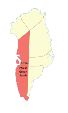
Kitaa, originally Vestgrønland ("West Greenland"), is a former administrative division of Greenland. It was by far the most populated of the divisions, being home to almost 90% of the total population. The divisions were de facto replaced by statistical regions after Greenland received home rule in 1979.
It is bordered in the west by the Baffin Bay, Davis Strait, Labrador Sea and the North Atlantic Ocean. To the east lies Tunu.
All but three of the island territory's municipalities were located in West Greenland. These were (in geographical order, from south to north):
- Nanortalik
- Qaqortoq
- Narsaq
- Ivittuut
- Paamiut
- Nuuk
- Maniitsoq
- Sisimiut
- Kangaatsiaq
- Aasiaat
- Qasigiannguit
- Ilulissat
- Qeqertarsuaq
- Uummannaq
- Upernavik
See also
- Subdivisions of Norden
- Administrative divisions of Greenland
- Isua greenstone belt (geology)
- v
- t
- e
Former administrative divisions of Greenland (until 31 December 2008)
- Eastern Settlement (Eystribygð) (c.985–c.1400)
- Western Settlement (Vestribygð) (c.985–c.1400)

- North Greenland (Nordgrønland) (1721–1950)
- South Greenland (Sydgrønland) (c.1728–1950)
- Colony of Greenland (1950–1953)
- County of Greenland (1950–1979)
- Avannaa (Nordgrønland) (1979–2008)
- Kitaa (Vestgrønland) (1979–2008)
- Tunu (Østgrønland) (1979–2008)
- Aasiaat
- Ammassalik
- Ilulissat
- Ittoqqortoormiit
- Ivittuut
- Kangaatsiaq
- Maniitsoq
- Nanortalik
- Narsaq
- Nuuk
- Paamiut
- Qaanaaq
- Qaqortoq
- Qasigiannguit
- Qeqertarsuaq
- Sisimiut
- Upernavik
- Uummannaq
- Vaigat (from 1972 part of Qeqertarsuaq Municipality)
- Kangerlussuaq (from 2002 part of Sisimiut Municipality)
- Pituffik
- Northeast Greenland National Park
68°00′N 52°00′W / 68.000°N 52.000°W / 68.000; -52.000
 | This Greenland location article is a stub. You can help Wikipedia by expanding it. |
- v
- t
- e


