Habitation de Québec
French colonial settlement
You can help expand this article with text translated from the corresponding article in French. (December 2012) Click [show] for important translation instructions.
- View a machine-translated version of the French article.
- Machine translation, like DeepL or Google Translate, is a useful starting point for translations, but translators must revise errors as necessary and confirm that the translation is accurate, rather than simply copy-pasting machine-translated text into the English Wikipedia.
- Do not translate text that appears unreliable or low-quality. If possible, verify the text with references provided in the foreign-language article.
- You must provide copyright attribution in the edit summary accompanying your translation by providing an interlanguage link to the source of your translation. A model attribution edit summary is
Content in this edit is translated from the existing French Wikipedia article at [[:fr:Habitation de Québec]]; see its history for attribution. - You may also add the template
{{Translated|fr|Habitation de Québec}}to the talk page. - For more guidance, see Wikipedia:Translation.

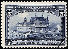
Habitation de Québec was an ensemble of buildings interconnected by Samuel de Champlain when he founded Québec during 1608. The site is located in what is now Vieux-Québec. It was located near the site of the abandoned First Nations village of Stadacona that Jacques Cartier had visited during 1535. It served as a fort and as dwellings for the new colony in New France.[1]
References
- ^ "Samuel de Champlain and the Founding of Quebec". The Canadian Encyclopedia. Retrieved 7 October 2019.
- v
- t
- e
New France
- French colonization of the Americas
- French colonial empire
- Timeline of New France history
- Beginnings–1533
- 1534–1607
- 1608–1662
- 1663–1759
- 1763 Treaty of Paris
- History of Quebec
- History of the Acadians
- History of the French-Americans
- Acadia (1604–1713)
- Canada (1608–1763)
- Terre-Neuve (1662–1713)
- Louisiana (1682–1763, 1801–1803)
- Île Royale (1713–1763)
- Illinois Country
- Ohio Country
- Pays d'en Haut
- Domaine du roy
villages
- Acadie
- Port Royal
- Canada
- Île Royale
- Louisiane
- Terre-Neuve
- Canada
- Acadie
- Terre-Neuve
- Louisiane
 Category

46°48′46″N 71°12′09″W / 46.8129°N 71.2025°W / 46.8129; -71.2025


