Golovnin


Golovnin
Golovnin in Russian Far East
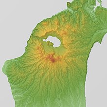
Golovnin (Japanese: 泊山, Tomari-yama; Russian: вулкан Головнина) is a caldera located in the southern part of Kunashir Island, Kuril Islands, Russia/Japan. It is the southernmost volcano of the Kuril Islands.
The russian name is given after the Russian explorer Vasily Golovnin.
An eruption was confirmed in 1948. It is not ranked as an active volcano by the Japan Meteorological Agency.Tomariyama Volcanic activity since recorded history
See also
References
- "Golovnin". Global Volcanism Program. Smithsonian Institution.
- v
- t
- e
- Alaid
- Atsonupuri
- Baransky
- Berutarube
- Bogatyr Ridge
- Chikurachki
- Chirinkotan
- Chirip
- Chirpoi
- Demon
- Ebeko
- Ekarma
- Fuss Peak
- Golets-Torny Group
- Golovnin
- Goryashchaya Sopka
- Grozny Group
- Ivao Group
- Karpinsky Group
- Ketoi
- Kharimkotan
- Kolokol Group
- Kuntomintar
- Lomonosov Group
- Lvinaya Past
- Medvezhya
- Mendeleyeva
- Milna (volcano)
- Nemo Peak
- Prevo Peak
- Raikoke
- Rasshua
- Rudakov
- Sarychev Peak
- Shirinki
- Sinarka
- Smirnov
- Srednii
- Tao-Rusyr Caldera
- Tyatya
- Tri Sestry
- Uratman
- Ushishur
- Vernadskii Ridge
- Zavaritski Caldera
| Authority control databases: Geographic |
|
|---|
 | This Sakhalin Oblast location article is a stub. You can help Wikipedia by expanding it. |
- v
- t
- e


