Fallstreak hole
Large gap in cirrocumulus or altocumulus clouds
| Fallstreak hole (Cavum) | |
|---|---|
 Fallstreak hole over Austria | |
| Abbreviation | cav |
| Genus | Cirrocumulus , Altocumulus , Stratocumulus |
| Variety | Supplementary feature |
| Altitude | 500-15,000 m (2,000-49,000 ft) |
| Appearance | Hole in the clouds |
| Precipitation | Virga |
A fallstreak hole (also known as a cavum,[1] hole punch cloud, punch hole cloud, skypunch, cloud canal or cloud hole) is a large gap, usually circular or elliptical, that can appear in cirrocumulus or altocumulus clouds. The holes are caused by supercooled water in the clouds suddenly evaporating or freezing, and may be triggered by passing aircraft.
Because of their rarity and unusual appearance, fallstreak holes have been mistaken for or attributed to unidentified flying objects.[2]
Origin
Such holes are formed when the water temperature in the clouds is below freezing, but the water, in a supercooled state, has not frozen yet due to the lack of ice nucleation. When ice crystals do form, a domino effect is set off due to the Wegener-Bergeron-Findeisen process, causing the water droplets around the crystals to evaporate; this leaves a large, often circular, hole in the cloud.[3] It is thought that the introduction of large numbers of tiny ice crystals into the cloud layer sets off this domino effect of fusion which creates the hole.
The ice crystals can be formed by passing aircraft, which often have a large reduction in pressure behind the wing-tip or propeller-tips. This cools the air very quickly, and can produce a ribbon of ice crystals trailing in the aircraft's wake. These ice crystals find themselves surrounded by droplets, and grow quickly by the Bergeron process, causing the droplets to evaporate and creating a hole with brush-like streaks of ice crystals below it. An early satellite documentation of elongated fallstreak holes over the Florida Panhandle that likely were induced by passing aircraft appeared in Corfidi and Brandli (1986).[4] Fallstreak holes are more routinely seen by the higher resolution satellites of today (e.g., see fourth example image in this article).
The articles by Westbrook and Davies (2010)[5] and Heymsfield et al. (2010)[6] explain the processes behind the formation of fallstreak holes in greater detail, and show some observations of their microphysics and dynamics. Such clouds are not unique to any one geographic area and have been photographed from many places.
Examples
-
 A fallstreak hole, Leeds, United Kingdom
 -
 Elongated fallstreak hole over Bixby
 -
 Fallstreak hole over Ann Arbor
 -
 A fallstreak hole over Borso del Grappa, Italy
 -
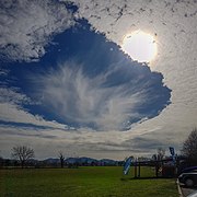
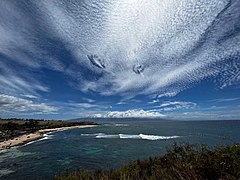 Fallstreak Holes over Ho'okipa beach on Maui, Hawai


See also
References
- ^ Sutherland, Scott (March 23, 2017). "Cloud Atlas leaps into 21st century with 12 new cloud types". The Weather Network. Pelmorex Media. Retrieved 24 March 2017.
- ^ "'UFO cloud formation' filmed in Romania (subscription required)". www.telegraph.co.uk. 26 October 2009. Retrieved 13 October 2021.
- ^ "Cloud Appreciation Society | Fallstreak Holes (February '06)". cloudappreciationsociety.org. 31 July 2006. Retrieved 2017-07-29.
- ^ Corfidi, Stephen; Brandli, Hank (May 1986). "GOES views aircraft distrails" (PDF). National Weather Digest. 11: 37–39.
- ^ Westbrook, Chris; Davies, Owain (July 2010). "Observations of a glaciating hole-punch cloud". Weather. 65 (7): 176–180. arXiv:0907.4302. Bibcode:2010Wthr...65..176W. doi:10.1002/wea.504. S2CID 37383288.
- ^ Heymsfield, Andrew J.; Kennedy, Patrick C.; Massie, Steve; Schmitt, Carl; Wang, Zhien; Haimov, Samuel; Rangno, Art (2010). "Aircraft-Induced Hole Punch and Canal Clouds: Inadvertent Cloud Seeding". Bulletin of the American Meteorological Society. 91 (6): 753–766. Bibcode:2010BAMS...91..753H. doi:10.1175/2009BAMs2905.1.
External links
Wikimedia Commons has media related to Cavum (meteorology).
- v
- t
- e
Cloud genera and selected species, supplementary features, and other airborne hydrometeors - WMO Latin terminology except where indicated
| Extreme-level 80–85 km |
|
|---|
| Very high-level 15–30 km |
|
|---|
| High-level 3–18 km |
| ||||||||||||||||||||||||||||
|---|---|---|---|---|---|---|---|---|---|---|---|---|---|---|---|---|---|---|---|---|---|---|---|---|---|---|---|---|---|
| Medium-level 2–8 km |
| ||||||||||||||||||||||||||||
| Low-level 0–2 km |
| ||||||||||||||||||||||||||||
| Non-height specific |
|


