Eygelshoven
Neighbourhood and former village in Kerkrade, Limburg, Netherlands
Eygelshoven Egelze | |
|---|---|
Neighbourhood and former village | |
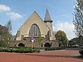
 The little church of Eygelshoven | |
 Coat of arms | |
50°54′N 6°3′E / 50.900°N 6.050°E / 50.900; 6.050 | |
| Country | Netherlands |
| Province | Limburg |
| Municipality | Kerkrade |
| Area | |
| • Total | 1.24 km2 (0.48 sq mi) |
| Elevation | 104 m (341 ft) |
| Population (2021)[1] | |
| • Total | 2,140 |
| • Density | 1,700/km2 (4,500/sq mi) |
| Time zone | UTC+1 (CET) |
| • Summer (DST) | UTC+2 (CEST) |
| Postal code | 6471[1] |
| Dialing code | 045 |
Eygelshoven (Dutch pronunciation: [ˈɛiɣəlsɦoːvə(n)], Limburgish: Egelze [ˈeːɣəlzə], Ripuarian: Ejelze [ˈeːjəlzə]) is a village, since 1982 part of the town of Kerkrade, in the southeast of the Netherlands, close to the German and Belgian borders.
It has two former coal mines, Laura and Julia, which were named after the wives of the two owners. Both pits closed in 1974. The local soccer club is also named after the former coal mines.
Eygelshoven has a small former church from the sixteenth century, which stands on top of a hill. In 1922, another church was built. Architect Alphons Boosten designed the new church. Plans to demolish the old church were abandoned in favour of a new use as a chapel and because of its historical worth.
A third Roman Catholic church was built in 1957, the Pastoor van Arskerk, which was torn down in 1994 when it became redundant.
The old mining village of Eygelshoven was a separate municipality until 1982, when after more than eight centuries it was merged with Kerkrade.[3]
The dialect spoken in Eygelshoven is not the Ripuarian Kerkrade dialect, but a local East Limburgish variety called Egelzer plat. One of the biggest differences between the two is the pronunciation of the letter ⟨g⟩; in Eygelshoven, it is pronounced as a voiced velar fricative, as in southern Standard Dutch, whereas in Kerkrade it is pronounced as a palatal approximant (as in Colognian), except after back vowels.
Transportation
Gallery
-
 Eygelshoven, church
 -
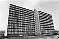 Apartment building which was later demolished (1976)
 -
 Houses in Eygelshoven
 -
 Former mine Julia


See also
References
- ^ a b c "Kerncijfers wijken en buurten 2021". Central Bureau of Statistics. Retrieved 24 April 2022.
- ^ "Postcodetool for 6471AA". Actueel Hoogtebestand Nederland (in Dutch). Het Waterschapshuis. Retrieved 24 April 2022.
- ^ Ad van der Meer and Onno Boonstra, Repertorium van Nederlandse gemeenten, KNAW, 2011.
External links
 Media related to Eygelshoven at Wikimedia Commons
Authority control databases | |
|---|---|
| International |
|
| National |
|
- v
- t
- e


