Escuinapa de Hidalgo
City in the Mexican state of Sinaloa
Place in Sinaloa, Mexico
Seal
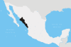
 Mexico
 (2010)
Escuinapa de Hidalgo is a city in Escuinapa Municipality of the same name, located at the extreme southern end of the Mexican state of Sinaloa. At the census of 2005 the city had a population of 28,789 inhabitants (the sixth-largest community in the state), while the municipality reported 49,655 inhabitants. The municipality has an area of 1633.22 km² (630.58 sq mi) and includes the towns of Isla del Bosque and Teacapan, in addition to many smaller localities.
References
- ^ "Principales resultados por localidad 2010 (ITER)". Instituto Nacional de Estadística y Geografía. 2010.
- Link to tables of population data from Census of 2005 INEGI: Instituto Nacional de Estadística, Geografía e Informática
- Sinaloa Enciclopedia de los Municipios de México
External links
![]() Media related to Escuinapa de Hidalgo at Wikimedia Commons
Media related to Escuinapa de Hidalgo at Wikimedia Commons
- Ayuntamiento de Escuinapa Official website
- v
- t
- e
 State of Sinaloa
Culiacán (capital)
and
(municipal seats)
- Ahome (Los Mochis)
- Angostura (Angostura)
- Badiraguato (Badiraguato)
- Choix (Choix)
- Concordia (Concordia)
- Cosalá (Cosalá)
- Culiacán (Culiacán)
- El Fuerte (El Fuerte)
- Eldorado (Eldorado)
- Elota (La Cruz)
- Escuinapa (Escuinapa de Hidalgo)
- Guasave (Guasave)
- Juan José Ríos (Juan José Ríos)
- Mazatlán (Mazatlán)
- Mocorito (Mocorito)
- Navolato (Navolato)
- Rosario (El Rosario)
- Salvador Alvarado (Guamúchil)
- San Ignacio (San Ignacio)
- Sinaloa (Sinaloa de Leyva)
Authority control databases | |
|---|---|
| International |
|
| National |
|
| Geographic |
|


