Dennis, North Carolina
Populated place in North Carolina, United States
36°13′30″N 80°10′12″W / 36.225°N 80.170°W / 36.225; -80.17027052
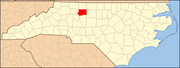
Dennis is a populated place in Forsyth County, North Carolina, United States.
History
Thomas Dennis Waddill built a depot in 1889 about halfway between Walkertown and Walnut Cove on the Roanoke & Southern Railroad. Waddill, who owned 1700 acres in the area, also built a mansion nearby which was demolished in the 1990s. Waddill became known as The Earl of Dennis. The depot burned in the 1930s. A post office and store were once located in the community.[1]
Geography
Dennis is located at latitude 36.2251371 and longitude -80.1700459.[2] The elevation is 846 feet.[3]
References
- ^ "Northwest Almanac: Dennis community named for resident who built railroad station, mansion in northeast Forsyth County". Winston-Salem Journal. August 13, 2018. Retrieved August 13, 2018.
- ^ "Dennis". Geographic Names Information System. United States Geological Survey, United States Department of the Interior. Retrieved April 16, 2021.
- ^ "Dennis (in Forsyth County, NC) Populated Place Profile". NC Hometown Locator. Retrieved August 13, 2018.
External links
- v
- t
- e
Municipalities and communities of Forsyth County, North Carolina, United States
County seat: Winston-Salem
communities
‡This populated place also has portions in an adjacent county or counties
- North Carolina portal
- United States portal
| Authority control databases: National |
|
|---|


