Dandenong Ranges
Mountain range in Victoria, Australia

Dandenong Ranges
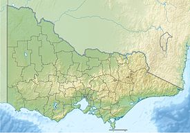
Location of the Dandenong Ranges in Victoria
The Dandenong Ranges (commonly just The Dandenongs) are a set of low mountain ranges in Victoria, Australia, approximately 35 km (22 mi) east of the state capital Melbourne. A minor branch of the Great Dividing Range, the Dandenongs consist mostly of rolling hills, rising to 633 m (2,077 ft) at Mount Dandenong, as well as steeply weathered valleys and gullies covered in thick temperate rainforest, predominantly of tall mountain ash trees and dense ferny undergrowth. The namesaked Dandenong Creek and most of its left-bank tributaries (particularly the Eumemmerring Creek) originate from headwaters in these mountain ranges. Two of Melbourne's most important storage reservoirs, the Cardinia and Silvan Reservoir, are also located within the Dandenongs.
After European settlement in the Port Phillip Bay region, the range was used as a major local source of timber for Melbourne. The ranges were popular with day-trippers from the 1870s onwards. Much of the Dandenongs were protected by parklands as early as 1882 and by 1987 these parklands were amalgamated to form the Dandenong Ranges National Park, which was subsequently expanded in 1997. The range receives light to moderate snowfalls a few times in most years, frequently between late winter and late spring.
Today, The Dandenongs are home to over 100,000 residents and are popular amongst visitors, many of whom stay for the weekend at the various bed & breakfasts throughout the region. The popular Puffing Billy Railway, a heritage steam railway, runs through the hills villages of the eastern Dandenong Ranges.
Geology and ecology


The range is the remains of an extinct volcano last active 373 million years ago.[1] It consists predominantly of Devonian dacite and rhyodacite.
The topography consists of a series of ridges dissected by deeply cut streams. Sheltered gullies in the south of the range are home to temperate rain forest, fern gullies and Mountain Ash forest Eucalyptus regnans, whereas the drier ridges and exposed northern slopes are covered by dry sclerophyll forest of stringybarks and box. The entire range is highly prone to bushfires, the most recent of which have been the 1983 Ash Wednesday bushfires, the 1997 Dandenong Ranges bushfires and small fires during the Black Saturday bushfires in 2009.
A number of watercourses originate in the Dandenongs, these include:
- Cardinia Creek
- Clematis Creek
- Dandenong Creek
- Eumemmerring Creek
- Emerald Creek
- Ferny Creek
- Mast Gully Creek
- Menzies Creek
- Monbulk Creek
- Muddy Creek
- Olinda Creek
- Sassafras Creek
- Sherbrooke Creek
- Stringy Bark Creek
- Wandin Yallock Creek
- Woori Yallock Creek
Waterfalls
- Olinda Falls
- Sherbrooke Falls
- Griffith Falls
Summits

| Summit Name | Height (m) | Comments | Location | Source[a] |
|---|---|---|---|---|
| Mount Dandenong | 630 | Tallest peak of the Dandenongs | Observatory Road, Mt Dandenong | DANDENONG ECC J survey mark |
| Mount Corhanwarrabul | 612 | Burkes lookout and location of transmission towers | Burkes Lookout Reserve, Eyre Road, Mt Dandenong | contour data |
| Olinda summit | 592 | No official name. Labelled Mt Olinda in older tourist maps. | Range Road, Olinda | contour data |
| Sassafras peak | 538 | No recorded name. | Cooloongatta Road, Sassafras | contour data |
| Dunns Hill | 562 | Location of a number of radio and telephone towers. | One Tree Hill Road, Ferny Creek | contour data |
| One Tree Hill | 500 | Lord Somers Road, Ferny Creek | contour data | |
| Tremont Hill | 395 | No official name. | Tremont Hill Track, Tremont | contour data |
| Chandlers Hill | 405 | Chandlers Track, Tremont | contour data | |
| Johns Hill | 419 | Johns Hill Reserve, Ridge Road, Kallista | JOHNS HILL ECC 1986 survey mark | |
| Black Hill | 374 | Black Hill Reserve, Two Bays Crescent, Selby | contour data | |
| Upwey Hill | 278 | Belmont Street, Upwey | contour data | |
| Lewis Hill | 298 | Queens Road, Silvan | contour data | |
| Nobelius Hill | 320 | Ambrose Street, Emerald | contour data | |
| Mount Morton | 275 | Chaundy Road, Belgrave South | MORTON ECC A survey mark |
Wildlife
The Dandenong Ranges are home to a variety of native Australian mammal, bird, reptile and invertebrate species. Well-represented bird species include the Sulfur-crested cockatoo, Superb lyrebird, Laughing kookaburra, and Crimson Rosella. Mammals include the Short-beaked echidna, Common wombat, Sugar glider, and Swamp wallaby. Invertebrates include two species of burrowing crayfish.
Climate
The Dandenong Ranges climate is generally mild and wet, with daily temperature variation generally low, often as low as 1 degree in the winter months. Rainfall is fairly uniform through the year, tending to peak between April and October with lower rainfall during January and February. The mean annual rainfall is between 1000 and 1500 mm, increasing with elevation and from west to east.[3] The elevation means that temperatures are typically 2 to 5 °C cooler than the lower suburbs of Melbourne to the west [1], with temperatures typically lowering by 1 °C for every 150 m of elevation. Due to the elevation, fog is common in the winter months.
As a result of its elevation, snow typically falls one or two times a year at higher elevations, mostly between June and October. A rare summer snow occurred on Christmas Day 2006 [2]. The local region has experienced substantial warming in recent decades [3] and heavy snowfalls which were once common have become rare. The last significant snowfall to affect the Dandenong Ranges was on August 10, 2008, when as much 15 cm (5.9 in) fell at the highest elevations.
A Bureau of Meteorology weather station sits at an elevation of 513 m in the Ferny Creek Reserve in the southern part of the Dandenong Ranges. This weather station replaced one that was previously located on the summit of Dunns Hill.

| Climate data for Mount Dandenong | |||||||||||||
|---|---|---|---|---|---|---|---|---|---|---|---|---|---|
| Month | Jan | Feb | Mar | Apr | May | Jun | Jul | Aug | Sep | Oct | Nov | Dec | Year |
| Record high °C (°F) | 37.3 (99.1) | 39.3 (102.7) | 33.6 (92.5) | 28.0 (82.4) | 20.3 (68.5) | 15.0 (59.0) | 16.0 (60.8) | 20.0 (68.0) | 22.7 (72.9) | 28.7 (83.7) | 33.2 (91.8) | 36.2 (97.2) | 39.3 (102.7) |
| Mean daily maximum °C (°F) | 22.1 (71.8) | 22.9 (73.2) | 19.7 (67.5) | 15.4 (59.7) | 11.7 (53.1) | 8.8 (47.8) | 8.2 (46.8) | 9.6 (49.3) | 11.6 (52.9) | 14.8 (58.6) | 17.3 (63.1) | 19.9 (67.8) | 15.2 (59.4) |
| Mean daily minimum °C (°F) | 11.5 (52.7) | 12.6 (54.7) | 11.3 (52.3) | 9.0 (48.2) | 6.0 (42.8) | 4.4 (39.9) | 3.6 (38.5) | 4.2 (39.6) | 5.0 (41.0) | 6.8 (44.2) | 8.3 (46.9) | 9.8 (49.6) | 7.8 (46.0) |
| Record low °C (°F) | 4.0 (39.2) | 4.7 (40.5) | 3.7 (38.7) | 0.7 (33.3) | −0.4 (31.3) | −1.0 (30.2) | −2.3 (27.9) | −2.0 (28.4) | −1.8 (28.8) | −0.6 (30.9) | 0.5 (32.9) | 2.3 (36.1) | −2.3 (27.9) |
| Average rainfall mm (inches) | 70.2 (2.76) | 61.2 (2.41) | 74.6 (2.94) | 102.0 (4.02) | 129.6 (5.10) | 98.4 (3.87) | 95.5 (3.76) | 116.8 (4.60) | 106.0 (4.17) | 104.8 (4.13) | 109.4 (4.31) | 95.7 (3.77) | 1,164.2 (45.84) |
| Average rainy days (≥ 0.2mm) | 12.1 | 8.4 | 12.4 | 13.7 | 18.2 | 17.8 | 20.0 | 19.7 | 17.5 | 16.5 | 15.2 | 12.9 | 184.4 |
| Source: Bureau of Meteorology[4] | |||||||||||||
Settlements in the Dandenong Ranges
Around 240,000 people live in and around the Dandenong Ranges, depending on the definition. The following settlements are located in the Dandenongs themselves (72,500~):
- Belgrave—3929[5]
- Belgrave Heights—1,500
- Belgrave South—1,500
- Clematis—350
- Emerald—6,000
- Ferny Creek—1,500
- Ferntree Gully - 10,000
- Kallista—1,000
- Kalorama—1,100
- Kilsyth—10,000
- Menzies Creek—1,300
- Monbulk—2,700
- Montrose—6, 500
- Mount Dandenong—1,300
- Olinda—1,500
- Sassafras—1,000
- Selby—1,400
- Tecoma—2,200
- The Patch—800
- Upper Ferntree Gully—4,000
- Upwey—6,800
Some settlements located on and around the plateau to the east of the ranges are sometimes included (14,200~):
- Cockatoo—4,500
- Gembrook—1,600
- Macclesfield—1,600
- Seville—2,000
- Seville East—600
- Silvan—1,900
- Wandin East—500
- Wandin North—1,600
Settlements in the southern and western foothills are also sometimes included (180,500~):
- Western Foothills
- The Basin—4,100
- Boronia—20,500
- Mount Evelyn—9,100
- Southern Foothills
- Endeavour Hills—24,000
- Narre Warren—26,000
- Berwick—47,000
- Narre Warren North—7,700
- Harkaway—849
- Beaconsfield Upper—2,861
History

The ranges are located near the boundary between the Wurundjeri and Bunurong people's territories. The two nations were part of the Kulin alliance and were most often on friendly terms. The mountain range, however, was not often frequented by either nations people as mountainous areas were often considered one of many resting places for various spirits.[citation needed]
In 1938, the aircraft Kyeema crashed on the western face of Mount Corhanwarrabul due to heavy fog and poor navigation. Eighteen people died.[6]
Utilities
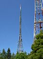
Transmission towers
There are several large television transmission towers on various summits that were initially constructed to broadcast TV to Central Victoria
- Channel 10/Channel 0, 204m high—Mount Corhanwarrabul (628m), (highest frequency)
- Channel 9, 131m high—Mount Corhanwarrabul (628m)
- Channel 7, 131m high—Mount Corhanwarrabul (628m), this tower is from interesting design, as it is a partially guyed tower, consisting of a free-standing lattice tower as basement and a guyed mast as pinnacle.
- Channel 2—Ferny Creek Summit (561m) (lowest frequency)
Channel 7, 9 and 10 all transmit from the 204M high ' Ornata Road ' TXA owned tower just to the South of Burke's Lookout. This tower also carries some of Melbourne, Victoria's commercial FM broadcast services. It also carries DAB+ digital radio services. Channel 2 services ( ABC, JJJ, emergency services, Govt owned ) transmit from the 130M high Broadcast Australia ' Eyre Road ' tower. This is an interesting tower in that the base is of four legged, freestanding design, while the upper portion is guyed by two sets of three guy cables. This tower is just to the North of Burke's Lookout. Adjacent to the Broadcast Australia tower, is the TXA ' Eyre Road ' standby tower, capable of transmitting 7, 9, and 10 signals in the event of an Ornata Road transmitter/antenna failure. This tower stands at 130M also and is a conventional four legged freestanding design. About 2 km to the North of this group of three towers, stands the original Channel 9 tower, built in 1956 to a height of 69M. This tower, on Observatory Road and adjacent to the Skyhigh lookout and restaurant now carries only some of Melbourne's commercial FM broadcast channels.
Tourism and attractions
- Scenic drives—popular for many years on the abundance of winding roads throughout the ranges
- Picnics—dedicated picnic areas can be found in Fern Tree Gully Picnic Ground or at One Tree Hill or in Sherbrooke Forest. Emerald Lake Park has a variety of pretty picnic spots with electric barbecues, sheltered areas and water activities. This park with landscaped gardens adjoins the historic Nobelius Heritage Park
- The various coffee shops and restaurants, bed and breakfasts, craft shops, antique shops and gardens
- Puffing Billy Railway—a narrow-gauge heritage steam railway, from Belgrave, through to Emerald, Cockatoo and ending at Gembrook
- Lookouts & views—There are several locations throughout the ranges that offer excellent views on both sides of the range. On a clear day, features as far as Mount Macedon, the You Yangs and Port Phillip can be seen simultaneously
- Walking & hiking—various tracks and trails are available at a variety of lengths and difficulties. For example; Four Brothers Rocks near Gembrook, Wright Forest near Cockatoo; The Eastern Dandenong Ranges Trail, which runs through Emerald, Cockatoo to Gembrook has a variety of open scenery and dappled woodland trails and at various stages follows the Puffing Billy railway line
Sherbrooke Falls, Sherbrooke
- Cycling—the Dandenong Ranges is one of Melbourne's most popular cycling areas. Popular road cycling climbs include the "1 in 20" on the Mountain Highway, "The Wall", a steeper route between Monbulk and Olinda, and the also-steep "Devil's Elbow", heading north from Upper Ferntree Gully along the Mount Dandenong Tourist Road to Ferny Creek . Also popular for picturesque and leisurely family bike rides is the Eastern Dandenong Ranges Trail, which runs through Emerald, Cockatoo to Gembrook
Regulations
Camping is not permitted within the National Park and fire restrictions may apply during the summer months. There are no rubbish bins in the national parks and visitors must leave with all items that they arrived with. Camping is permitted near Gembrook at Kurth Kiln Regional Park. Please stay informed and be prepared, so as to ensure you have a fun and safe experience. It is important to observe weather conditions and warnings during the bushfire season and follow official recommendations.
Bushfires
Due to the climate of the region, the type of vegetation and the topography, the Dandenong Ranges periodically experience bushfires. Some of the recent occurrences included:
- 1851—Black Thursday
- 1898
- 1905
- 1913
- 1926
- 1939
- 1962
- 1968
- 1983—Ash Wednesday, 27 deaths in the Dandenong ranges
- 1997—3 deaths in the ranges
- 2009—Black Saturday, no deaths in the ranges

Gallery
-
 The 1000 steps
 -
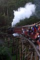 Puffing Billy on the Trestle Bridge
 -
 View of Melbourne from the summit of Mount Dandenong
 -
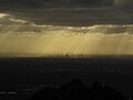 View of Melbourne from the summit of Mount Dandenong
 -
 Mount Dandenong as seen from Kilsyth
 -
 Transmission towers on the summit of Mount Corhanwarrabul
 -
 Transmission towers. Note that the upper parts of the tower in the background are guyed.
 -
 Channel 10 transmission tower
 -
 Channel 9 transmission tower
 -
 Channel 7 transmission tower
 -
 The Silvan Reservoir looking east from Kalorama


See also
References
- ^ Birch, William D. (1994). Volcanoes in Victoria. Royal Society of Victoria. ISBN 0730606279.
- ^ https://maps.land.vic.gov.au/lassi/ Land and Survey Spatial Information, State of Victoria (Department of Environment, Land, Water and Planning). Accessed 15 June 2020.
- ^ "Climate statistics for Australian locations - Dunns Hill". Australian Government Bureau of Meteorology. Retrieved 24 September 2017.
- ^ "MOUNT DANDENONG GTV9". Climate statistics for Australian locations. Bureau of Meteorology. May 2013. Retrieved 1 June 2013.
- ^ "2016 Census QuickStats: Belgrave". quickstats.censusdata.abs.gov.au. Retrieved 3 June 2020.
- ^ "The Crash of Kyeema" (PDF). Flight safety Australia. November 1998. Archived from the original (PDF) on 29 September 2007. Retrieved 24 September 2017.
External links
Wikimedia Commons has media related to Dandenong Ranges.
Wikivoyage has a travel guide for Dandenong Ranges.
- Accommodation - 1000 Reasons [4]
- Eastern Dandenong Ranges
- Blue Dandenongs
- Parks Victoria
- Info sourced from Knox Historical Society on place names in the area
- The dandenongs in colour
- v
- t
- e
- William (1,167 m or 3,829 ft)
- Difficult
- Wilson
- Zero (364 m or 1,194 ft)
| Bogong High Plains |
|
|---|---|
| Cathedral Range |
|
| Cobberas Range |
|
| Cobbler Plateau |
|
| Other |
|
mountain ranges
| Central Highlands |
|
|---|---|
| Dandenong Ranges |
|
| Pyrenees Ranges |
|
| Strzelecki Ranges |
|
| Other |
|
| Authority control databases |
|
|---|


