Protected wilderness area in California, United States
34°15′21″N 115°48′39″W / 34.25583°N 115.81083°W / 34.25583; -115.81083| Area | 39,167 acres (158.50 km2) |
|---|
| Established | 1994 |
|---|
| Governing body | Bureau of Land Management |
|---|
The Cleghorn Lakes Wilderness is a 39,167-acre (158.50 km2) wilderness area in the southern Mojave Desert. It is located 16 miles (26 km) northeast of Twentynine Palms, California, and 20 miles (32 km) north of Joshua Tree National Park. It is managed by the Bureau of Land Management.[2]
Named for the dry lakes found at the center of the wilderness area, this area has a variety of natural resources. The east portion is mountainous while the west portion is a vast alluvial fan and bajada. Elevations range from 1,400 feet (430 m) at the desert floor to the rugged Bullion Mountains, which rise more than 4,100 feet (1,200 m) across a 4-mile (6.4 km) stretch.[2]
Natural history
Wildlife includes Desert bighorn sheep on the slopes, and desert tortoise in the valley floor and bajada habitats.
Native plants include: Barrel cactus, and Smoke trees (Psorothamnus spinosus)" in some bajadas. The Cleghorn Lakes offer occasional spring wildflower displays. The Crucifixion Thorn (Castela emoryi) shrub has been found near the eastern edge of the wilderness boundary. It is native to California, Arizona, and Sonora state in Mexico. It listed by the California Native Plant Society as rare in California, but is more common elsewhere in the lower Sonoran Deserts.[3]
See also
- Flora of the California desert regions
- Natural history of the Mojave Desert
- Protected areas of the Mojave Desert
References
- ^ Protected Planet Website- Retrieved March 30, 2023
- ^ a b "BLM: Cleghorn Lakes Wilderness". Archived from the original on 2009-03-05. Retrieved 2009-03-26.
- ^ "Taxon Report". Retrieved 2009-03-26.
External links
- Bureau of Land Management−BLM: official Cleghorn Lakes Wilderness website
- U.S. Geological Survey Map at the U.S. Geological Survey Map Website. Retrieved March 30, 2023.
National Park System |
|---|
| Parks | |
|---|
| Preserves | |
|---|
| Monuments | |
|---|
| Seashores | |
|---|
| Historical Parks | |
|---|
| Historic Sites | |
|---|
| Memorials | |
|---|
| Recreation Areas | |
|---|
|
|
|
|---|
| Parks | |
|---|
| Natural Reserves | |
|---|
| Marine Reserves | |
|---|
| Historic Parks | |
|---|
| Beaches | |
|---|
| Recreation Areas | |
|---|
Vehicular
Recreation Areas | |
|---|
| Other | |
|---|
|
|
National Forests and Grasslands |
|---|
National Forests
and Grasslands | |
|---|
National Wilderness
Preservation System | |
|---|
National Monuments
and Recreation Areas | |
|---|
|
|
|
|
|
|---|
Wildlife
Areas | |
|---|
Ecological
Reserves | |
|---|
Marine
Protected
Areas | |
|---|
|
|
|
|---|
| National Monuments | |
|---|
National
Conservation Areas | - California Desert
- King Range
|
|---|
| Wilderness Areas | |
|---|
|
|
|
|
|
|
|
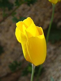 Native Parish's poppy (Eschscholzia parishii) flowering in the preserve
 Large rare Crucifixion Thorn (Castela emoryi) shrub


