Clearwater Wilderness
47°03′28″N 121°49′27″W / 47.05778°N 121.82417°W / 47.05778; -121.82417Area 14,647 acres (59.27 km²) Established 1984 Governing body United States Forest Service Federal State Other
Clearwater Wilderness is a 14,647-acre (5,927 ha) wilderness area in the North Cascades mountain range, in northern Washington state, of the Northwestern United States.[1][2] It is located in the Mount Baker-Snoqualmie National Forest, southeast of Tacoma in northeastern Pierce County.
It was created by Congress in 1984, under the 1964 Wilderness Act that established the National Wilderness Preservation System. Its southern border reaches Mount Rainier National Park, affording views of Mount Rainier from its trails.[1]
Description
Bearhead Mountain, the highest peak of the Clearwater Wilderness, is 6,089 feet (1,856 m) in elevation. Below are the headwaters of the north-flowing Clearwater River, and many streams. Eight small lakes, including Summit Lake, are within the wilderness area.
Old-growth forests of Douglas fir, western hemlock and western redcedar are protected, and are reachable by hiking trails.[3] The forest understory is made up mostly of ferns and mosses.[2]
The season between October and May receives 90 percent of the area's annual precipitation. Snow in amounts reaching 25 ft (7.6 m) can remain as late as July in high areas.[4][2]
Wildlife in the area includes bears, deer, marmots, elk, cougars and pikas, as well as birds like eagles, grouse and songbirds.[3]
Trails
- Summit Lake Trail is an easy 2.5-mile-long (4.0 km) hike up 1,500 feet (460 m) to Summit Lake. Mount Rainier can be seen from a high point near the lake.[5][6]
- Clearwater Trail is a difficult 8.1-mile (13.0 km) hike over the Clearwater River and a number of creeks, and through old growth and meadows.[7][8]
- Carbon Trail has the same trailhead as Clearwater Trail and meanders south for 9.4 miles (15.1 km) to join the Summit Lake Trail.[2]
Gallery
-
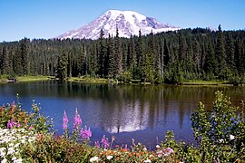 Mount Rainier, seen from the Clearwater Wilderness
 -
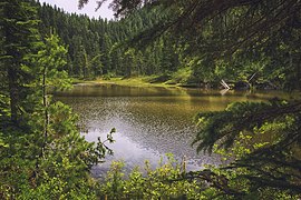 Twin Lake, on the Summit Lake Trail
 -
 Summit Lake trail


References
- ^ a b "Clearwater Wilderness". Nature of the Northwest. Archived from the original on 2006-09-30. Retrieved 2006-10-21.
- ^ a b c d "Clearwater Wilderness". fs.usda.gov. Retrieved 2022-08-01.
- ^ a b "Clearwater Wilderness". Wilderness Connect. Retrieved 2022-08-01.
- ^ "Clearwater Wilderness". National Wilderness Preservation System. Archived from the original on 2006-09-12. Retrieved 2006-10-21.
- ^ "Summit Lake". Hiker Bob Trail Guides. Archived from the original on 2004-01-29. Retrieved 2006-10-21.
- ^ "Summit Lake Trail 1177". fs.usda.gov. Retrieved 2022-08-01.
- ^ "Clearwater River". Hiker Bob Trail Guides. Archived from the original on 2005-03-01. Retrieved 2006-10-21.
- ^ "Clearwater Trail 1178". fs.usda.gov. Retrieved 2022-08-01.
External links
 Media related to Clearwater Wilderness at Wikimedia Commons
- Clearwater Wilderness on the United States Forest Service website
- Clearwater Wilderness on Wilderness.net
- Clearwater Wilderness Trail Guides - Map
- College of Forestry and Conservation - Clearwater Wilderness at archive.today (archived April 16, 2013)
- v
- t
- e
Protected areas of Washington
| Former state parks |
|---|
- Marine protected areas
- Blanchard Forest
- Cascadia Marine Trail
- The Enchantments
- Goose Island
- Les Hilde Trail & Trailheads
- Little Pend Oreille
- Maritime Washington National Heritage Area
- Mount Adams Recreation Area
- Sehome Hill Arboretum
- Walker Valley ORV Riding Area
- Withrow Moraine
- Yellow Island


