Carrara, Nevada
Ghost town in Nevada, United States
Carrara, Nevada | |
|---|---|
Ghost town | |
| Country | United States |
| State | Nevada |
| County | Nye County |
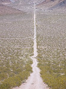
Carrara is a ghost town in Nye County, Nevada.[1] The townsite is located in the Amargosa Desert adjacent to US Route 95 about 8.5 miles southeast of Beatty. The old Tonopah and Tidewater Railroad line was about one half mile to the southwest. An old road, previously a railroad grade, runs straight for about 3 miles to the northeast up Carrara Canyon on the southeast flank of the Bare Mountains to an old marble quarry. The quarry is about 1400 feet higher in elevation than the townsite.[2]
A post office was established at Carrara in 1913, and remained in operation until 1924.[3] The community was named after the Carrara marble.[4]
References
- ^ U.S. Geological Survey Geographic Names Information System: Carrara (historical)
- ^ Bare Mountain, Nevada, 15 minute Topographic Quadrangle, USGS, 1954
- ^ U.S. Geological Survey Geographic Names Information System: Carrara Post Office (historical)
- ^ Federal Writers' Project (1941). Origin of Place Names: Nevada (PDF). W.P.A. p. 55.
External links
- Carrara on Ghosttowns.com, with photo gallery
36°48′03″N 116°42′44″W / 36.80083°N 116.71222°W / 36.80083; -116.71222
- v
- t
- e
Municipalities and communities of Nye County, Nevada, United States
County seat: Tonopah
- Amargosa Valley
- Beatty
- Gabbs
- Manhattan
- Pahrump
- Round Mountain
- Tonopah
unincorporated
communities
reservations
- Nevada portal
- United States portal
 | This Nye County, Nevada state location article is a stub. You can help Wikipedia by expanding it. |
- v
- t
- e
 | This United States ghost town-related article is a stub. You can help Wikipedia by expanding it. |
- v
- t
- e


