Bruinisse
Village in Zeeland, Netherlands

Coat of arms
51°39′37″N 4°5′36″E / 51.66028°N 4.09333°E / 51.66028; 4.09333
(2021)[1]
4311[1]
Bruinisse is a village in the south-west of the Netherlands. It is located in the municipality of Schouwen-Duiveland, Zeeland.
History
The village was first mentioned in 1480 or 1481 as "Brunesse ... noviter erecta", and is a combination of headland and mud.[3] Bruinisse was originally an island.[4] In 1452, Philip the Good gave permission to build dikes and polder the salt marshes. The polder was completed in 1468. Bruinisse is a front street village with half a ring road around the church. The economy was mainly based on mussel fishing. The harbour was extended in 1872 and 1912.[5]
The Reformed Church is a neoclassic aisleless church built in 1904 as a replacement of the 1868 church. In 1962, it was restored and the entrance was moved to the side.[5] Bruinisse was home to 1,430 people in 1840.[4]
Bruinisse was severely damaged during World War II. On 12 February 1944, the land around Bruinisse was inundated by the Germans and bombed by the Allies on 5 January 1945 causing the destroying of many houses including the church from 1467.[4] The village was flooded during the North Sea flood of 1953.[5] In 1964, the Grevelingendam was built connecting Schouwen-Duiveland with Goeree-Overflakkee.[4] A recreational centre with marina was constructed to the north-west of the village.[5]
Bruinisse was a separate municipality until 1997, when it was merged into Schouwen-Duiveland.[6]
Gallery
-
 Dutch Reformed Church
 -
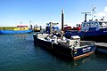 Harbour of Bruinisse
 -
 Street view


References
- ^ a b c "Kerncijfers wijken en buurten 2021". Central Bureau of Statistics. Retrieved 20 April 2022.
- ^ "Postcodetool for 4311AA". Actueel Hoogtebestand Nederland (in Dutch). Het Waterschapshuis. Retrieved 20 April 2022.
- ^ "Bruinisse - (geografische naam)". Etymologiebank (in Dutch). Retrieved 20 April 2022.
- ^ a b c d "Bruinisse". Plaatsengids (in Dutch). Retrieved 20 April 2022.
- ^ a b c d Piet van Cruyningen & Ronald Stenvert (2003). Bruinisse (in Dutch). Zwolle: Waanders. ISBN 90 400 8830 6. Retrieved 20 April 2022.
- ^ Ad van der Meer and Onno Boonstra, Repertorium van Nederlandse gemeenten, KNAW, 2011.
External links
- www.bru.nu
| Authority control databases |
|
|---|


