Boleboř
Municipality in Ústí nad Labem, Czech Republic

Flag

Coat of arms
 Czech Republic
 (2023-01-01)[1]
431 21
Boleboř (German: Göttersdorf) is a municipality and village in Chomutov District in the Ústí nad Labem Region of the Czech Republic. It has about 300 inhabitants.
Boleboř lies approximately 8 kilometres (5 mi) north of Chomutov, 47 km (29 mi) west of Ústí nad Labem, and 88 km (55 mi) north-west of Prague.
Administrative parts
The villages of Orasín and Svahová are administrative parts of Blatno.
Demographics
| Year | Pop. | ±% |
|---|---|---|
| 1869 | 941 | — |
| 1880 | 885 | −6.0% |
| 1890 | 847 | −4.3% |
| 1900 | 826 | −2.5% |
| 1910 | 788 | −4.6% |
| 1921 | 785 | −0.4% |
| 1930 | 788 | +0.4% |
| 1950 | 239 | −69.7% |
| 1961 | 233 | −2.5% |
| 1970 | 277 | +18.9% |
| 1980 | 222 | −19.9% |
| 1991 | 171 | −23.0% |
| 2001 | 194 | +13.5% |
| 2011 | 224 | +15.5% |
| 2021 | 310 | +38.4% |
| Source: Censuses[2][3] | ||
Gallery
-
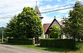 Church of Saint Nicholas
 -
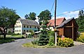 The village of Orasín


References
- ^ "Population of Municipalities – 1 January 2023". Czech Statistical Office. 2023-05-23.
- ^ "Historický lexikon obcí České republiky 1869–2011 – Okres Chomutov" (in Czech). Czech Statistical Office. 2015-12-21. pp. 1–2.
- ^ "Population Census 2021: Population by sex". Public Database. Czech Statistical Office. 2021-03-27.
External links
Wikimedia Commons has media related to Boleboř.
- Official website
- v
- t
- e
- Bílence
- Blatno
- Boleboř
- Březno
- Černovice
- Chbany
- Chomutov
- Domašín
- Droužkovice
- Hora Svatého Šebestiána
- Hrušovany
- Jirkov
- Kadaň
- Kalek
- Klášterec nad Ohří
- Kovářská
- Křimov
- Kryštofovy Hamry
- Libědice
- Loučná pod Klínovcem
- Málkov
- Mašťov
- Měděnec
- Místo
- Nezabylice
- Okounov
- Otvice
- Perštejn
- Pesvice
- Pětipsy
- Račetice
- Radonice
- Rokle
- Spořice
- Strupčice
- Údlice
- Vejprty
- Veliká Ves
- Vilémov
- Vrskmaň
- Všehrdy
- Všestudy
- Výsluní
- Vysoká Pec
| Authority control databases: National |
|
|---|
 | This Ústí nad Labem Region location article is a stub. You can help Wikipedia by expanding it. |
- v
- t
- e


