Bohdaneč
Municipality in Central Bohemian, Czech Republic

Flag

Coat of arms
 Czech Republic
 (2023-01-01)[1]
285 25
Bohdaneč is a municipality and village in Kutná Hora District in the Central Bohemian Region of the Czech Republic. It has about 400 inhabitants.
Administrative parts
The villages and hamlets of Dvorecko, Kotoučov, Prostřední Ves, Řeplice and Šlechtín are administrative parts of Bohdaneč.
Geography
Bohdaneč is located about 19 kilometres (12 mi) south of Kutná Hora and 58 km (36 mi) southeast of Prague. It lies in the Upper Sázava Hills. The highest point is at 546 m (1,791 ft) above sea level. The stream of Ostrovský potok originates here, flows across the municipal territory and supplies two notable fishponds in the area: Pilský and Karbanův.
History
The first written mention of Bohdaneč is from 1233. In 1514, Bohdaneč was promoted to a market town by Vladislaus II of Hungary, but lost the title after World War II. Dvorecko was first mentioned in 1487 under name Víceměřič. Kotoučov was first mentioned in 1525 and Prostřední Ves and Řeplice in 1381.[2]
Šlechtín was a part of Prostřední Ves. In 1960, the municipalities of Dvorecko, Kotoučov, Prostřední Ves and Řeplice were merged with Bohdaneč.[2]
Demographics
|
|
| ||||||||||||||||||||||||||||||||||||||||||||||||||||||
| Source: Censuses[3][4] | ||||||||||||||||||||||||||||||||||||||||||||||||||||||||
Sights
The most important monument is the Church of the Annunciation. It was originally built in the Gothic style in the mid-14th century. Baroque modifications were made in the 1760s and in 1868.[5]
Gallery
-
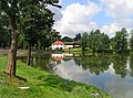 Pilský Pond
 -
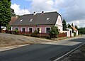 Old farm
 -
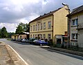 Municipal office


References
- ^ "Population of Municipalities – 1 January 2023". Czech Statistical Office. 2023-05-23.
- ^ a b "Historie" (in Czech). Obec Bohdaneč. Retrieved 2022-04-20.
- ^ "Historický lexikon obcí České republiky 1869–2011 – Okres Kutná Hora" (in Czech). Czech Statistical Office. 2015-12-21. pp. 1–2.
- ^ "Population Census 2021: Population by sex". Public Database. Czech Statistical Office. 2021-03-27.
- ^ "Kostel Zvěstování Panny Marie" (in Czech). National Heritage Institute. Retrieved 2023-06-30.
External links
Wikimedia Commons has media related to Bohdaneč.
- Official website
- v
- t
- e
Towns, market towns and villages of Kutná Hora District
- Adamov
- Bernardov
- Bílé Podolí
- Bludov
- Bohdaneč
- Brambory
- Bratčice
- Čáslav
- Čejkovice
- Černíny
- Červené Janovice
- Čestín
- Chabeřice
- Chlístovice
- Chotusice
- Církvice
- Dobrovítov
- Dolní Pohleď
- Drobovice
- Hlízov
- Horka I
- Horka II
- Horky
- Horušice
- Hostovlice
- Hraběšín
- Kácov
- Kluky
- Kobylnice
- Košice
- Krchleby
- Křesetice
- Kutná Hora
- Ledečko
- Malešov
- Miskovice
- Močovice
- Nepoměřice
- Nové Dvory
- Okřesaneč
- Onomyšl
- Opatovice I
- Paběnice
- Pertoltice
- Petrovice I
- Petrovice II
- Podveky
- Potěhy
- Rašovice
- Rataje nad Sázavou
- Řendějov
- Rohozec
- Samopše
- Schořov
- Šebestěnice
- Semtěš
- Slavošov
- Soběšín
- Souňov
- Staňkovice
- Starkoč
- Štipoklasy
- Sudějov
- Suchdol
- Svatý Mikuláš
- Třebešice
- Třebětín
- Třebonín
- Tupadly
- Uhlířské Janovice
- Úmonín
- Úžice
- Vavřinec
- Vidice
- Vinaře
- Vlačice
- Vlastějovice
- Vlkaneč
- Vodranty
- Vrdy
- Záboří nad Labem
- Žáky
- Zbizuby
- Zbraslavice
- Zbýšov
- Žehušice
- Žleby
- Zruč nad Sázavou
| Authority control databases: National |
|
|---|


