Beuel
Municipal district Stadtbezirk of Bonn.jpg
You can help expand this article with text translated from the corresponding article in German. (August 2019) Click [show] for important translation instructions.
- View a machine-translated version of the German article.
- Machine translation, like DeepL or Google Translate, is a useful starting point for translations, but translators must revise errors as necessary and confirm that the translation is accurate, rather than simply copy-pasting machine-translated text into the English Wikipedia.
- Do not translate text that appears unreliable or low-quality. If possible, verify the text with references provided in the foreign-language article.
- You must provide copyright attribution in the edit summary accompanying your translation by providing an interlanguage link to the source of your translation. A model attribution edit summary is
Content in this edit is translated from the existing German Wikipedia article at [[:de:Beuel]]; see its history for attribution. - You may also add the template
{{Translated|de|Beuel}}to the talk page. - For more guidance, see Wikipedia:Translation.
Borough of Bonn in North Rhine-Westphalia, Germany

Coat of arms
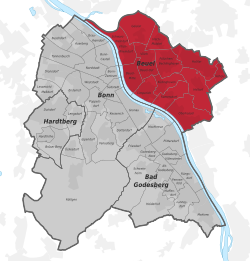
Beuel within Bonn
50°44′0″N 07°7′20″E / 50.73333°N 7.12222°E / 50.73333; 7.12222
(2020-12-31)[1]
Beuel (Ripuarian: Büel) is a city borough (Stadtbezirk) of Bonn, Germany. It has a population of 67,827 (2020).
Subdivisions
Beuel is composed of the sub-districts Beuel-Mitte, Beuel-Ost, Geislar, Hoholz, Holtorf, Holzlar, Küdinghoven, Limperich, Oberkassel, Pützchen/Bechlinghoven, Ramersdorf, Schwarzrheindorf/Vilich-Rheindorf, Vilich and Vilich-Müldorf.
Twin towns – sister cities
Beuel is twinned with:[2]
 Mirecourt, France (1969)

References
- v
- t
- e
Districts of Bonn
- Bonn
- Bad Godesberg
- Beuel
- Hardtberg
- Alt-Godesberg
- Auerberg
- Beuel-Mitte
- Beuel-Ost
- Bonn-Castell
- Bonn-Zentrum
- Brüser Berg
- Buschdorf
- Dottendorf
- Dransdorf
- Duisdorf
- Endenich
- Friesdorf
- Geislar
- Godesberg-Nord
- Godesberg-Villenviertel
- Graurheindorf
- Gronau
- Hardthöhe
- Heiderhof
- Hochkreuz
- Hoholz
- Holtorf
- Holzlar
- Ippendorf
- Kessenich
- Küdinghoven
- Lannesdorf
- Lengsdorf
- Lessenich/Meßdorf
- Limperich
- Mehlem
- Muffendorf
- Nordstadt
- Oberkassel
- Pennenfeld
- Plittersdorf
- Poppelsdorf
- Pützchen/Bechlinghoven
- Ramersdorf
- Röttgen
- Rüngsdorf
- Schwarzrheindorf/Vilich-Rheindorf
- Schweinheim
- Südstadt
- Tannenbusch
- Ückesdorf
- Venusberg
- Vilich
- Vilich-Müldorf
- Weststadt
Authority control databases | |
|---|---|
| International |
|
| National |
|
 | This Bonn location article is a stub. You can help Wikipedia by expanding it. |
- v
- t
- e


