Baadarâne
Town in Mount Lebanon Governorate
Baadarâne بعدران | |
|---|---|
Town | |
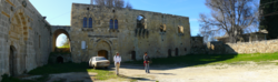 Remains of a palace in Baadarâne, Shouf, Lebanon | |
| 33°38′10.3″N 35°37′08.9″E / 33.636194°N 35.619139°E / 33.636194; 35.619139 | |
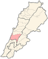
| Country |  Lebanon Lebanon |
| Governorate | Mount Lebanon Governorate |
| District | Chouf District |
| Lowest elevation | 1,050 m (3,440 ft) |
| Time zone | UTC+2 (EET) |
| • Summer (DST) | UTC+3 (EEST) |
| Dialing code | +961 |
Baadarâne (Arabic: بعدران Baʿdarān), is an area in Chouf, Mont Liban, Lebanon.[1] Baadarane is 60 kilometres (37 mi) away from Beirut at an elevation of 1,050 meters .[2][3]
Baadarane is a town with an elevation of 1050m. It is known for the remains in al (Meydan) which is an old building and is located on a mountain so the weather is cold and especially in winter, snow covers the town.
Airport
The area is home to an abandoned airfield built during the Lebanese Civil War but never operated as active aerodrome.[4] The concrete runway is the only visible infrastructure.
References
- v
- t
- e

Capital: Beitedine
- Ain Qani
- Ain W Zain
- Ain Zhalta
- Ainbal
- Ammatour
- Baadarâne
- Baakleen
- Bakaata
- Barja
- Barouk
- Batloun
- Beitedine
- Beykoun
- El Bireh
- Bourjein et Marjiyat
- Boutmeh
- Brih
- Bsaba
- Dahr El Maghara
- Damour
- Daraya
- Deir el Qamar
- Dibbiyeh
- El Foûâra
- Haret Jandal
- Gharife
- Jahlieh
- Jdaideh
- Jieh
- Joun
- Kahlouniye
- Kfarfakoud
- Kfar Nabrakh
- Mazraat el-Chouf
- Mazraat el Daher
- Maasser
- Moukhtara
- Mtolleh
- Na'ameh
- Niha
- Rmeileh
- Serjbel
- Shheem
- Symkanieh
- Zaarourieh
 | This Lebanon location article is a stub. You can help Wikipedia by expanding it. |
- v
- t
- e


