Únehle
Municipality in Plzeň, Czech Republic

Flag

Coat of arms
 Czech Republic
 (2023-01-01)[1]
349 01
Únehle is a municipality and village in Tachov District in the Plzeň Region of the Czech Republic. It has about 100 inhabitants.
Únehle lies approximately 30 kilometres (19 mi) east of Tachov, 26 km (16 mi) west of Plzeň, and 106 km (66 mi) west of Prague.
Demographics
| Year | Pop. | ±% |
|---|---|---|
| 1869 | 326 | — |
| 1880 | 343 | +5.2% |
| 1890 | 316 | −7.9% |
| 1900 | 312 | −1.3% |
| 1910 | 327 | +4.8% |
| 1921 | 299 | −8.6% |
| 1930 | 299 | +0.0% |
| 1950 | 156 | −47.8% |
| 1961 | 146 | −6.4% |
| 1970 | 136 | −6.8% |
| 1980 | 102 | −25.0% |
| 1991 | 103 | +1.0% |
| 2001 | 109 | +5.8% |
| 2011 | 119 | +9.2% |
| 2021 | 138 | +16.0% |
| Source: Censuses[2][3] | ||
Gallery
-
 Bus stop
 -
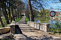 Stone bridge
 -
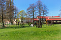 Playground


References
- ^ "Population of Municipalities – 1 January 2023". Czech Statistical Office. 2023-05-23.
- ^ "Historický lexikon obcí České republiky 1869–2011 – Okres Tachov" (in Czech). Czech Statistical Office. 2015-12-21. pp. 19–20.
- ^ "Population Census 2021: Population by sex". Public Database. Czech Statistical Office. 2021-03-27.
External links
Wikimedia Commons has media related to Únehle.
- Official website
- v
- t
- e
Towns, market towns and villages of Tachov District
- Benešovice
- Bezdružice
- Bor
- Brod nad Tichou
- Broumov
- Částkov
- Cebiv
- Černošín
- Chodová Planá
- Chodský Újezd
- Ctiboř
- Dlouhý Újezd
- Erpužice
- Halže
- Horní Kozolupy
- Hošťka
- Kladruby
- Kočov
- Kokašice
- Konstantinovy Lázně
- Kostelec
- Kšice
- Lesná
- Lestkov
- Lom u Tachova
- Milíře
- Obora
- Olbramov
- Ošelín
- Planá
- Přimda
- Prostiboř
- Rozvadov
- Skapce
- Staré Sedliště
- Staré Sedlo
- Stráž
- Stříbro
- Studánka
- Sulislav
- Svojšín
- Sytno
- Tachov
- Tisová
- Třemešné
- Trpísty
- Únehle
- Vranov
- Záchlumí
- Zadní Chodov
- Zhoř
| Authority control databases: National |
|
|---|
 | This Plzeň Region location article is a stub. You can help Wikipedia by expanding it. |
- v
- t
- e


