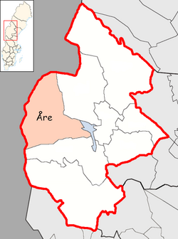
Åre Municipality
Municipality in Jämtland County, Sweden
Åre Municipality Åre kommun | |
|---|---|
Municipality | |
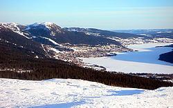 Åresjön and Åre seen from the Mullfell in nearby Duved | |
 Coat of arms | |
 | |
| Coordinates: 63°21′N 13°28′E / 63.350°N 13.467°E / 63.350; 13.467 | |
| Country | Sweden |
| County | Jämtland County |
| Seat | Järpen |
| Area | |
| • Total | 8,236.54 km2 (3,180.15 sq mi) |
| • Land | 7,199.45 km2 (2,779.72 sq mi) |
| • Water | 1,037.09 km2 (400.42 sq mi) |
| Area as of 1 January 2014. | |
| Population (31 December 2023)[2] | |
| • Total | 12,464 |
| • Density | 1.5/km2 (3.9/sq mi) |
| Time zone | UTC+1 (CET) |
| • Summer (DST) | UTC+2 (CEST) |
| ISO 3166 code | SE |
| Province | Jämtland |
| Municipal code | 2321 |
| Website | www.are.se |
Åre Municipality (Swedish: Åre kommun, Southern Sami: Ååren tjïelte) is a municipality in Jämtland County in northern Sweden. Its seat is located in Järpen.
The present municipality was formed in 1974 through the amalgamation of "old" Åre Municipality with the surrounding municipalities Hallen, Kall, Mörsil and Undersåker. The largest village, Järpen, situated in Undersåker, was chosen as the seat of the new entity.
Localities
There are six localities (or urban areas) in Åre Municipality:[3]
| # | Locality | Population |
|---|---|---|
| 1 | Järpen | 1,439 |
| 2 | Åre | 1,260 |
| 3 | Mörsil | 674 |
| 4 | Duved | 637 |
| 5 | Undersåker | 384 |
| 6 | Hallen | 223 |
The municipal seat in bold
Demographics
This is a demographic table based on Åre Municipality's electoral districts in the 2022 Swedish general election sourced from SVT's election platform, in turn taken from SCB official statistics.[4]
In total there were 12,246 residents, including 9,076 Swedish citizens of voting age.[4] 57.9% voted for the left coalition and 40.9% for the right coalition. Indicators are in percentage points except population totals and income.
| Location | Residents | Citizen adults | Left vote | Right vote | Employed | Swedish parents | Foreign heritage | Income SEK | Degree |
|---|---|---|---|---|---|---|---|---|---|
| % | % | ||||||||
| Duved-Storlien | 2,396 | 1,741 | 62.3 | 37.2 | 80 | 85 | 15 | 26,023 | 48 |
| Hallen-Marby | 1,150 | 931 | 46.2 | 52.3 | 87 | 94 | 6 | 23,991 | 35 |
| Järpen | 1,876 | 1,357 | 57.2 | 41.5 | 79 | 76 | 24 | 21,625 | 26 |
| Kall | 543 | 440 | 52.6 | 44.1 | 87 | 90 | 10 | 22,750 | 28 |
| Mattmar | 545 | 425 | 51.1 | 48.0 | 86 | 93 | 7 | 24,523 | 40 |
| Mörsil | 1,191 | 805 | 48.5 | 50.4 | 80 | 74 | 26 | 23,103 | 30 |
| Undersåker | 2,162 | 1,572 | 65.3 | 33.8 | 84 | 91 | 9 | 26,561 | 55 |
| Åre | 2,383 | 1,805 | 60.4 | 38.5 | 80 | 90 | 10 | 26,744 | 51 |
| Source: SVT[4] | |||||||||
Notable people
- Henrik Lundqvist – Former goalkeeper for the New York Rangers of the National Hockey League, and the Frölunda Indians of the Swedish Hockey League, gold medalist in the Winter Olympics in 2006. Born in Åre, though he moved to Båstad to support his sister's tennis career. He is twins with Joel Lundqvist.
- Joel Lundqvist – center for the Frölunda Indians (SHL), former center for the Dallas Stars (NHL), 2 time world champion. Born in Åre, though he moved to Båstad to support his sister's tennis career. He is twins with Henrik Lundqvist.
Gallery
-
 View of Åre, postcard sent on September 27, 1904 (postal rate 0:05)
 -
 Sunrise over Åresjön
 -
 Lake and ski slope on Björnen side of Åreskutan
 -
 The cable car in Åre
 -
 The gondola lift to the top of the Åre Ski Area
 -
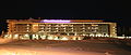 Copperhill Mountain Lodge hotel in Åre
 -
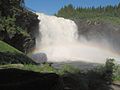 Tännforsen
 -
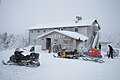 Vita Renen hostel and café on Renfjället


See also
References
- ^ "Statistiska centralbyrån, Kommunarealer den 1 januari 2014" (in Swedish). Statistics Sweden. 2014-01-01. Archived from the original (Microsoft Excel) on 2016-09-27. Retrieved 2014-04-18.
- ^ "Folkmängd och befolkningsförändringar - Kvartal 4, 2023" (in Swedish). Statistics Sweden. February 22, 2024. Retrieved February 22, 2024.
- ^ Statistics Sweden as of December 31, 2005
- ^ a b c "Valresultat 2022 för Åre i riksdagsvalet" (in Swedish). SVT. 11 September 2022. Retrieved 21 January 2024.
External links
Wikimedia Commons has media related to Åre Municipality.
Wikivoyage has a travel guide for Åre.
- Åre Municipality - Official site
- VisitAre.com - Tourism site
- Åre Bike Park - Official site
- Åre Bike Festival - Official site
- www.are-sweden.com - Information on Are Ski resort
Places adjacent to Åre Municipality | |
|---|---|


Authority control databases | |
|---|---|
| International |
|
| National |
|
| Geographic |
|


